First, here are the weather stats for January from the NWS:

I suspect this will probably be the nicest day of the week before we turn towards a more active weather pattern when the snow and perhaps the coldest air we have seen in a couple of years move into SW Michigan. We could see another six inches of the white stuff by Saturday morning from the synoptic system and lake effect on the backside. It is still early and this is bond to change higher or lower. When the really cold air drops in next week the snow totals should start piling up depending on which way the winds blow. Stay tuned…
Weather History
January 31
1914: A snowstorm drops from 6 to 14 inches of snow across southern Lower Michigan.
1977: One of the coldest months on record comes to a close with yet more arctic air and lake effect snow. High temperatures are only in the teens during the last week of the month with 2 to 4 feet of snow piled up along the Lake Michigan snow belts.
February 1
1918: February opens on a frigid note during one of the most severe winters in history across the central and eastern United States. Muskegon tumbles to a record cold 22 degrees below zero and Lansing also sets a record with 16 below.
February 2
1868: It is a chilly Groundhog Day as Lansing sets their all-time record low with a reading of 37 below zero.
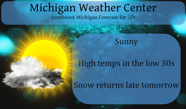
February 3
2007: Blizzard conditions prevail across southwest Lower Michigan as an arctic blast of frigid air moving over Lake Michigan produces thundersnow and whiteout conditions. Grand Rapids sets a record for snowfall for any February day with 11.3 inches of snow.
February 4
1838: An ice jam on the Grand River causes flooding of much of Grand Rapids during early February. Several people had to be rescued from flooded neighborhoods and at the fur trading post.
1996: One of the coldest arctic outbreaks of the 20th century sends the thermometer down to 17 below zero at Grand Rapids and 19 below at Muskegon, both records for the date.
February 5
1890: Temperatures more like April than February prevail during one of the mildest winters on record in Lower Michigan. Lansing sets a record high of 61 degrees for the second day in a row.
1918: Frigid weather holds on across Lower Michigan with the temperature falling to record lows of 16 below zero at Muskegon and 21 below at Lansing.
February 6
1895: Lower Michigan is in the midst of a week long siege of arctic air. High temperatures struggle through the single numbers while morning lows fall well below zero. Lansing falls to 14 below zero on this date after lows of 24 below on the 4th and 20 below on the 5th. Grand Rapids hits 9 below after falling to 16 below on the 5th.
1938: The weight of ice and water carried away the west side of the Rogue river dam at Childsdale.The Souffrow bridge near North Belmont was closed to traffic as its footing had been swept away by the river. Several houses along the east bank of the Grand River were flooded.
2008: Near blizzard conditions occur across part of Lower Michigan with snowfall rates of one to two inches per hour. More than a foot of snow fell north of Interstate 96 to Route 10. Further south, a wintry mix of snow, sleet and freezing rain occurred from Kalamazoo to Jackson. The storm drops more than 8 inches of snow at Grand Rapids, contributing to the snowiest February on record with 41.6 inches.
2019: An ice jam on the Grand River in Portland caused flooding along Water Street in downtown Portland, where about 50 people were evacuated from their homes. The ice jam shifted and thickened a couple days later, causing additional flooding. Many businesses along Kent Street were flooded, and people along Canal and Market streets were evacuated. The ice jam held for more than three weeks before finally melting and shifting downstream. Some homes on Water Street experienced continuous flooding for most of this three week period.
Indy, you will like the latest 16 day GFS.
https://www.instantweathermaps.com/GFS-php/conussfc.php?run=2021020318&time=PER&var=ASNOWI&hour=384
I just spit out my Sprite great Scotty!! INDY
>>>>>>BREAKING WEATHER ALERT>>>>>>> Kent county should be placed in a WINTER STORM WARNING! GGR May see 8 to 12 inches of snow by Sunday along with high winds, drifting and low visibilities! Stay tuned for later updates and the RDB model snowfall outlook! Incredible!
Check out the latest NAM through Saturday!
http://wxcaster.com/gis-snow-overlays2.php?STATIONID=GRR
Wow just wow ….GET TO THE STORE NOW AND GRAB MORE!! INDY ..
I agree Rocky nothing like the old days of getting a foot of snow and having a winter storm watches and then warnings the NWS has stepped back on there watches and warnings to advisorys now but don’t be surprised if this goes to a warning overnight or tomorrow good chance of it .. … Facts prepare now folks it’s going to be bad Friday lots of closings coming and slippery roads ….INDY
The latest GFS.
http://wxcaster.com/gis-gfs-snow-overlays2.php?STATIONID=GRR
I am surprised the NWS went with a WWA, because with the wind, low visibilities, bad roads and possible +6 inches of snow it may end up as a WSWarning! I think it should be a WS watch right now and then upgraded tomorrow!
You don’t see GR in the shades of orange on this map very often! I love it!
https://www.pivotalweather.com/model.php?m=gfs&p=snku_acc&rh=2021020312&fh=384&r=conus&dpdt=&mc=
Wow just wow….INDY
Nice sunny day outside we can call this the calm before old man Winter hits us hard in the face with plenty more Winter fun days ahead let’s hit month and half with snow pack on the ground straight when was the last time that happened?? I really can’t remember woo woo! DDDDDD!! INDY
I love back loaded winters and the Polar Vortex! Feb is going to wild!!!!!!
Crazy totals on the January stats! 9 inches of snow for GR? I’d take that every year. Even better is a Winter that does absolutely nothing until a few weeks in February. Way different than it used to be.
Crazzy the GFS model shows lake effect snow showers through Saturday February 13th that could mean lots of accumulation building up wow just wow ….Back loaded Winter fun! INDY ..
Two warm days in February so far and two more on the way. I can handle a week or two of true winter. I love short winters!
Lol…..So basically see you in two weeks hu?? ..Good ridence….Get ready for Winter storm watches coming this afternoon!!! INDY
More like good riddance till at least next month! It is going to be a winter rock n roll party for weeks on end!
We got down to a sultry 6.6 degrees this morning – our coldest low temp for the season thus far…
It got down to +8.4 here for the coldest low here. But that was much colder then the official low at Grand Rapids and that has happened now two days in a row.
Slim
Check out Terri D wood tv 8 video forcast this morning could be looking at 2 feet of snow or more near the lake shore and over a foot of snow inland counties by next week several rounds of heavy lake effects snows coming wow just wow ..Can’t make this up ….INDY
Gale watch for Thursday night into Friday for wind guest over 40mph out of the west that will fire the lake effect snow machine up look out west Michigan here comes the watches …..Stay tuned ..INDY
Indy, it is a misconception That high winds are good for lake effect. We do much better with lake effect with less wind as there needs to be time over the lake to pick up the moisture. So look for less lake effect with the high wind but more later if the deep cold gets here. More so if there can be some short waves as well. As for winter storm watches or warning I would expect that.
Slim
Here is the formula for lake effect snow: Lake Snow Parameter (LSP) =
WF(850 mb Temp) x WF(850-700 mb RH) x WF (1000-850 mb WS (Wind Speed))
of the three factors included, wind speed has the least overall impact on the LSP
More on this tomorrow.
Great set up for west Michigan to get blasted this weekend coming ….INDY
Also strong winds carry the bands inland. So for inland areas, strong winds sometimes mean more lake effect
Winter storm watches coming this afternoon and possibly blizzard warnings to follow could it be ?? West Michigan is going to get hammered Friday Saturday and Sunday get to the store now and grab more I can see lots of school closings Friday as roads become impassable this winter storm means business followed by the coldest air in two years and tons of lake effect snows …. Prepare now models show over 20 inches of snow for west Michigan by next week!! GREAT SCOTTY!! Stay tuned ….INDY
Check this out! Let real winter begin! I love it!
https://www.pivotalweather.com/model.php?m=gfs&p=snku_acc&rh=2021020306&fh=384&r=conus&dpdt=&mc=