
Thanks to our weather historian Slim for his post yesterday on the data for September and Autumn, if you haven’t checked it out do so as his posts are always an interesting read.
Today we begin an extended period of hot weather. Today will be at or near 90° with dewpoints rising into the mid-60s. Wind will be out of the south/southwest at 20 to 25 mph. If you are going to Lake Michigan to seek relief take note of the beach hazards statement below.

Be aware of high wave action especially north of St Joseph today. Waves will build into the 3 to 5-foot range by afternoon. Strong currents and locally higher waves will exist on the south sides of piers. Stay dry when the waves are high.
Grand Rapids Forecast
9 3 grrU.S.A and Global Events for September 3rd:
1821: Known as the 1821 Norfolk Long Island Hurricane, this storm ripped up the Mid-Atlantic and Northeast coast on September 3 and 4 – coinciding with Labor Day (before the holiday was established). Click HERE for more information from AMS.
On this day in 1821, the “famous” Norfolk-Long Island hurricane occurred – “the only major hurricane to pass over New York City.” It was probably a strong major hurricane when making landfall in North Carolina, but I have serious doubts it was a major when passing over New York. pic.twitter.com/roV8kKanp6
1834: A strong hurricane made landfall near Georgetown, South Carolina.
On this date in 1834, a strong hurricane made landfall near Georgetown, SC. Maybe a major hurricane, but I never found enough good proof. pic.twitter.com/hjBGYytfFY
1930: A Category 4 hurricane devastates the Dominican Republic on this day. This storm killed more than 8,000 individuals, which is the fifth deadliest Atlantic hurricane on record.
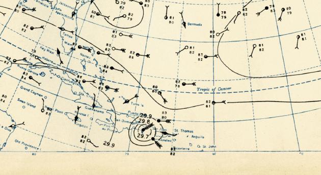
Cropped Version of September 3, 1930, Weather Map, Courtesy of NOAA.

1970: During the early evening hours, amid a severe hailstorm at Coffeyville, Kansas, a stone 17.5 inches in circumference and nearly two pounds in weight was recovered. The average stone size from the storm was five inches in diameter, with another stone reportedly eight inches in diameter. This hailstone is currently the third-largest hailstone in the U.S.

NCAR scientist Nancy Knight holds a hailstone that fell in Coffeyville, Kansas, in 1970. The largest hailstone ever documented, it weighs 0.75 kilograms (1.67 pounds) and spans 14.4 centimeters (5.67 inches).
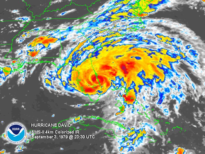
1979: Hurricane David made landfall in South Florida as a Category 2 storm. It caused 15 deaths in the US. Hurricane David was a Category 5 over the Dominican Republic where over 2,000 people died.
Forecast Discussion
The short term is looking quite uneventful at this time, with only
the building heat being of interest through Monday (and beyond in
the long term).

The wave that passed by to our north on Saturday, and generated a
few light showers and storms across Central Lower is long gone to
our east. This is allowing the ridge to build back up a bit over the
area. Plenty of dry air remains in the column, except for the
boundary layer, and above 12-15k ft agl. This dry air, combined with
temperatures aloft warming a bit (850 mb warming from 20C to 22-24C)
will keep any rain from forming today and through Monday.

These 850 mb temperatures, with plenty of sunshine will support max
temps around 90 F today away from Lake Michigan, and the lower 90s
on Monday. Lows tonight will drop in the 60s with dew points not
expected to increase significantly through Monday.

...Hot and humid for Tuesday...

Deep and persistent warm air advection will continue to build the
heat here in MI through Tuesday.  The moisture will also be on the
increase, especially Tuesday, ahead of an approaching cold front.
With surface dewpoints staying above 70, that will keep overnight
lows way above normal, possibly near record warm overnight lows for
at least Tuesday.  Ensemble max temperatures for Tuesday show the
models coming into better agreement with values mostly in the upper
80`s to lower 90`s.  Combining those values with the higher
dewpoints yields max heat index values in the upper 90`s, which is a
little under advisory criteria.

- Storms possible with the cold front Wednesday

Ensemble surface based CAPE values show mean values are likely to
top 1000 J/kg during the day on Wednesday. This is ahead of the cold
front that is forecast to arrive in the afternoon.  The 0-6km Bulk
Shear Values are relatively low, generally under 30 knots.  This
suggests the storms will be pulse in nature, but given the CAPE an
isolated strong/svr storm appears possible.

- Cooling off for Thursday

A mid level low deepens as it crosses the state on Thursday. This
feature will act to cool off the temperatures.  At this point there
is good agreement in the ensemble forecasts showing max temperatures
in the 70`s which is what we will forecast for Thursday and beyond.
If we end up with more sun than forecast, the models may be a few
degrees off with the max temperatures.
After a couple warm days we go right back to out ever persistent cool pattern by Thursday! Wow, just wow, WOW! Incredible pattern!
There is a mention of record warm minimums for Monday and Tuesday nights here are the record warm lows for those two days. For September 5th the record warm low is 71 set in 1985 and 1912 a low of 70 was set in 1969. For September 6th the record warmest low is 73 set in 1922 and 1893, a low of 72 was recorded in 1985 and 1912. and a warm low of 71 was set in 2016. For a record low for the 4th to be set it would have to stay above 73 tonight.
Slim
Yesterday was a great early September day with the official H/L of 81/56 at Grand Rapids. There were 0 HDD’s and 4 CDD’s there was no rain fall and the sun was out 43% of the time. The highest wind speed was 29 MPH out of the SW. For today the average H/L is 78/58 the record high of 95 was set in 1898 and 1953 the record low of 32 was set in 1946 this is the earliest fall reading of 32 or below at Grand Rapids. The most rain fall of 1.42” fell in 1988. Last year the… Read more »