I am putting on hold our weekly weather history post because of the storm bulletins we have in place.
It is better to be prepared than not when the NWS prognosticators tell us the weather will be frightful in the coming days. I have been through the blizzard of 1978 and multiple snow events in Michigan that paused life as we know it. In the early 70s, I saw snow storms from noreasters in the foot-per-hour range fall in northern Maine and Quebec, making our storms look tame by comparison. They had huge trucks with snow blowers which took care of it so nothing would be closed, plus their road system was not like we have here in Michigan.
All of Michigan is under a winter storm watch. This is the Grand Rapids office’s take on the timeline of the storm:
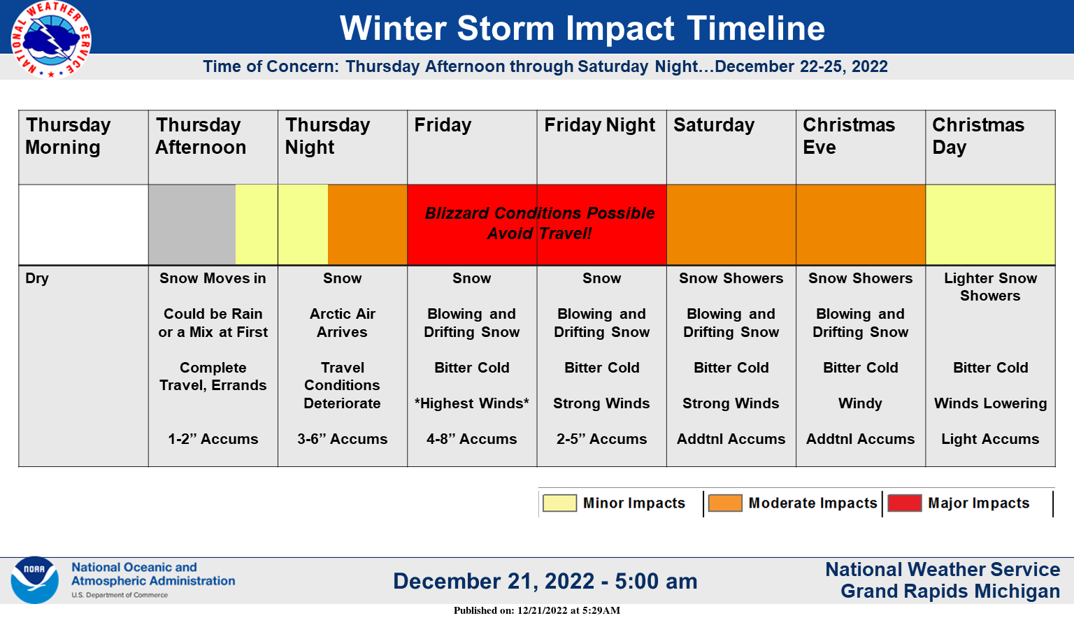
Try to complete travel, errands, and Christmas shopping by Thursday evening as conditions will deteriorate rapidly with the arrival of a major winter storm. Be prepared for the possibility of blizzard conditions Friday and Friday night with travel becoming very difficult if not impossible.
This is from the Gaylord office:
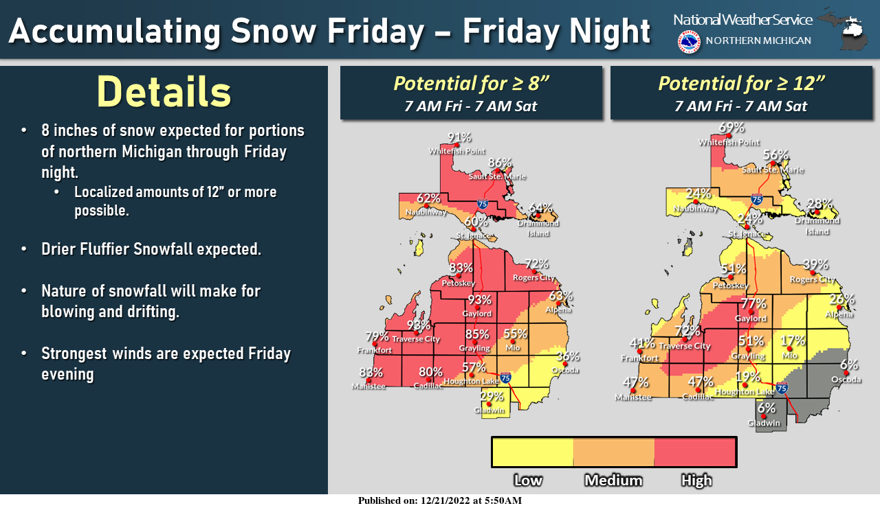
The snow will become more fluffy and drier as we head into Friday and Friday night. The winds will begin to gust past 40-50 mph during Friday evening. The nature of this snowfall will make for major blowing and drifting, as well as whiteouts. Be sure to use caution if traveling!
This is from the Detroit Office:
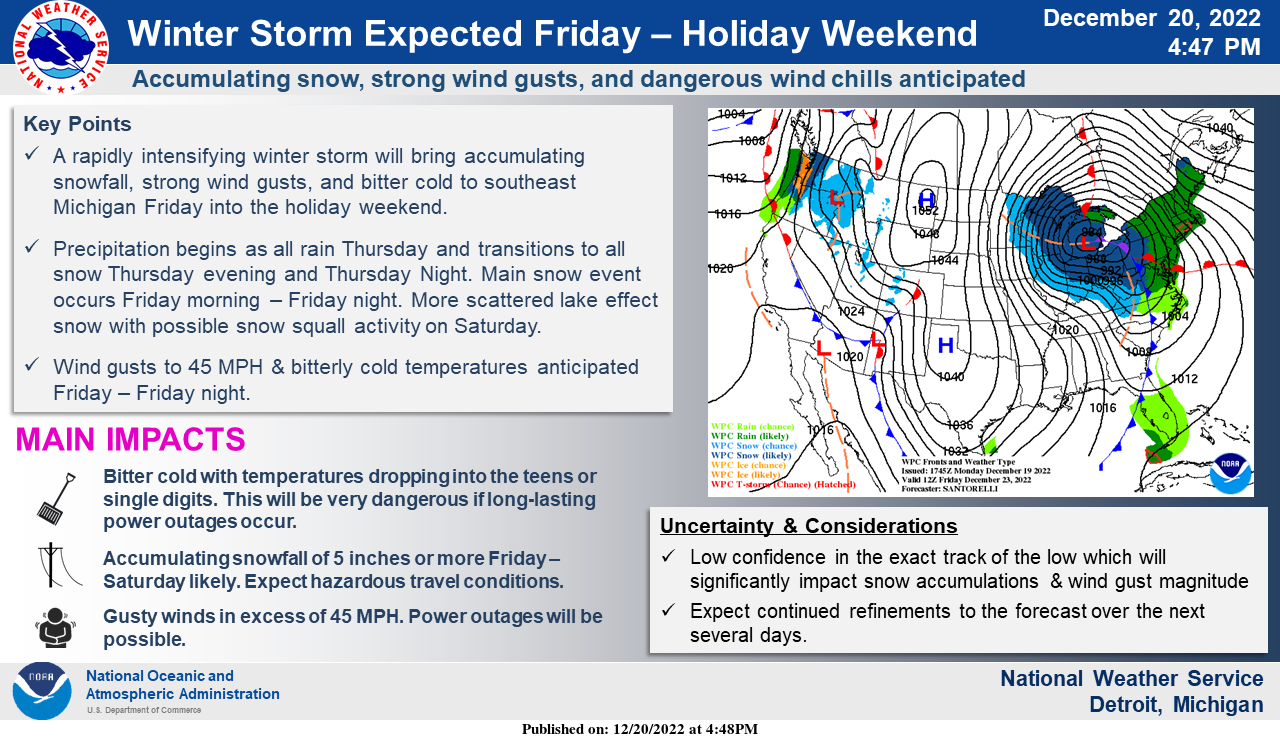
A rapidly intensifying winter storm will bring accumulating snowfall, strong wind gusts, and bitter cold to southeast Michigan Friday into the holiday weekend.
The Marquette NWS office:
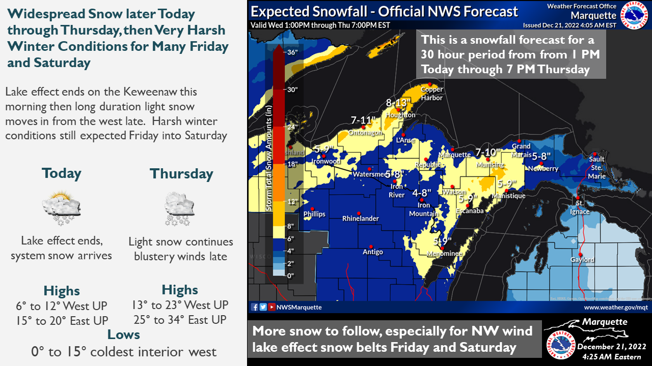
Lingering lake effect snow off western Lake Superior will end early this morning with widespread system snow arriving shortly after. Moderate accumulations are expected through Thursday afternoon. Expect very harsh winter conditions for most of Friday and Saturday with strong winds, blowing snow, and additional snowfall mainly confined to the northwest wind snow belts
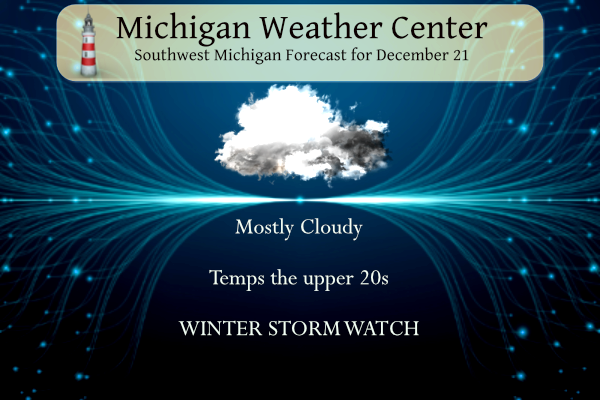
Winter Storm Watch for SW Michigan
...WINTER STORM WATCH REMAINS IN EFFECT FROM THURSDAY AFTERNOON
THROUGH SATURDAY EVENING...

* WHAT...Blizzard conditions possible Friday. Winds could gust as
  high as 55 mph and will cause significant blowing and drifting
  snow. Storm total snowfall through Saturday in excess of a foot
  along and west of US 131 from Kalamazoo northward to Grand
  Rapids and Big Rapids.

* WHERE...Portions of central, south central, southwest and west
  central Michigan.

* WHEN...From Thursday afternoon through Saturday evening.

* IMPACTS...Travel could be very difficult to impossible. Areas
  of blowing snow could significantly reduce visibility. The
  hazardous conditions will impact the commutes and holiday
  travel. Strong winds could cause tree damage leading to power
  outages. Subzero wind chills are expected Friday into Saturday.

* ADDITIONAL DETAILS...Snow will develop Thursday afternoon and
  evening. It will become heavy at times Thursday night. The risk
  for heavy snow will persist through Friday. The widespread snow
  will become more lake effect Friday night into Saturday. The
  strongest winds are expected Friday into Friday evening.
  Snowfall rates of an inch per hour are expected. The temperature
  will be falling from around freezing Thursday afternoon...into
  the 20s Thursday night with increasing impacts expected on the
  roadways then.
7-Day Forecast 42.27°N 85.64°W 12 21
Forecast Discussion
- Major winter storm late Thursday through Saturday -

Bottom line up front... a winter storm watch remains in effect
for our entire fcst area from Thursday afternoon through Saturday
evening (no headline or major fcst changes with this early morning
fcst issuance). An overall short to medium range guidance
consensus continues to show potential for significant snow
accumulations from late Thursday afternoon through Friday with
blizzard conditions Friday.

It is noticed though that overall medium range guidance trends
the past 12-24 hours suggest that the low will track a bit
further east than it looked yesterday at this time. This is
particularly noticeable in the 00Z deterministic ecmwf and 00Z eps
which has a 982 mb low just nw of Toronto by 12Z Fri (yesterday
the ecmwf ensemble mean suggested a 980 mb sfc low would be
located further nw over Lake Huron by 12Z Fri).

This shift further east is significant in that it causes cold air
to move into our area sooner (no pcpn type issues Thur eve). It
also no longer supports a trowal this far southwest and has less
qpf and less snowfall for our area while now showing potential
for heavier snow over eastern lower MI in closer proximity to the
sfc low. My gut feeling is that all the cold dense arctic air
already pouring into the upper midwest across MN/WI/IA could force
the low on a bit further east track as suggested by latest
model trends which would mean potentially less synoptic snow
accumulations in our area.

All things considered though a consensus blend of latest short to
medium range guidance still supports significant snow late
Thur/Thur night through Friday. Some of our guidance is likely
underdone with snowfall amounts since falling temps through the
day Friday will lead to increasingly favorable snow ratios. Snow
combined with very strong winds will cause blizzard conditions
regardless of how much snow ultimately falls across our area.

So at this time our forecast and messaging will remain very
consistent with previous forecasts and we still expect a major
winter storm with significant snow and blizzard conditions and
scattered to potentially numerous power outages Friday into
Saturday.

Future shifts will need to continue to monitor guidance trends
very closely in terms of low strength and track. It will make all
the difference in terms of total snow accumulations and therefore
just how impactful this storm becomes in our area (the difference
between blizzard conditions at times Friday versus a crippling
snowstorm that makes travel very difficult if not impossible for
days on end if we end up with one to two feet of snow and drifts
much higher than that). The furthest west 00z deterministic
gfs/00z gefs ensemble low position over Saginaw Bay at 12Z Fri
with trowal in our area are the solutions most conducive to
highest end synoptic snow accumulations.

By Saturday we expect significant impacts from cold temps and
windy conditions and blowing and drifting snow. Several additional
inches of lake effect snow are likely in our favored nw flow snow
belt regions. However the magnitude of wind speeds Saturday will
limit airmass residency time over Lake MI and carry les far inland
such that all of our area will get lake effect snow showers.
However the greatly dispersed nature of lake effect snow showers
across our area will tend to limit accumulations in any particular
location given the strong winds. Very cold thermal profiles
Saturday will also result in a very fine powdery snow which will
also limit potential accumulations somewhat.

In the nearer term... tranquil wx will continue today with partly
cloudy skies and seasonably cold temps.
New post is in process for a blizzard warning…
…BLIZZARD WARNING IN EFFECT FROM 4 PM THURSDAY TO 7 PM EST SATURDAY… * WHAT…Blizzard conditions expected Friday. Total snow accumulations of 10 to 20 inches. Winds gusting as high as 45 mph. * WHERE…Portions of southwest and west central Michigan. * WHEN…From 4 PM Thursday to 7 PM EST Saturday. * IMPACTS…Travel will be very difficult to impossible. Widespread blowing snow will significantly reduce visibility. The hazardous conditions will mainly impact Friday and Saturday travel. * ADDITIONAL DETAILS…While the snow will start by mid afternoon on Thursday, the strong winds will not start until Friday morning. It is then… Read more »
I will be interested to see the snowfall reports tomorrow and Saturday. It will be virtually impossible to measure with any sort of accuracy.
NWS GR says a total of 6-10 for us, which is what our local mets have been saying.
This morning you said your local Mets said only 4 to 6 inches and I told you they were wrong!
You are mistaken. They said 4-6 synoptic snow, and then several more inches from LE.
Nice!
They issued the blizzard warning! This is getting exciting now
Well there it is. Blizzard warnings for all the counties along and west of 131. First blizzard warning for GR since 2011!!
The battle of the major weather models is now on. The 12Z GFS at 48hrs has a 978 low over Detroit while the ECMWF at that time has a 982 low over Buffalo, NY. For Grand Rapids at 48 Hrs the GFS has a temperature of 21 and the ECMWF has it at +8. As for wind the GFS at 48 hrs has a NW wind at GR (not good for lake effect) and the ECMWF has a west wind. So that’s how things stand at this time at around noon on Friday. Pick the one you want to believe… Read more »
Northern Indiana NWS just put out Blizzard warnings we will be next probably the first two rollls of countys in west Michigan im thinking at the 4pm discussion get the big Daddy hats out folks here comes a Blizzard… Bill Steffens predicted one this year hes amazing…INDY
Poo.. just one more county over please 🙂 I need that fulfillment of being under a Blizzard Warning !!
After coordinating with nearby offices, we are planning to issue a Winter Storm Warning for our eastern counties from Thursday evening until Saturday morning (likely 7 am). For our western CWA very likely we will issue a blizzard warning from Thursday evening through Saturday afternoon. The latest model trends over the past 3 runs of those model have stopped backing off on QPF and continue to support the idea of sustained winds in the 25 mph range with gusts to 40 mph on Friday. So the reason to have a blizzard warning over the western counties is that there would… Read more »
The only concern I have is it seems the synoptic snow does not last that long, ending Friday morning. And the wind direction for lake effect favors areas SW of Grand Rapids. But clearly I am missing something, otherwise they would not be forecasting 8-17 for Kalamazoo to Grand Rapids to Big Rapids
The system snow will not be done on Friday morning and lake effect snow will be effecting Grand Rapids!
Wood tv 8 hasn’t changed there snow amounts looks like 12 to 18 inches for GR dont take this storm lightly….INDY
Who would have thought?
Torregrossa is chiming in:
https://www.mlive.com/weather/2022/12/up-to-2-feet-of-snow-in-first-detailed-snowfall-forecast-for-pre-christmas-blizzard.html
That looks about right, however GR will be picking up more than a foot of snow! Get ready!
With the current data that looks about right. Of note is that even at this range things can still change. For some reason Mother Nature dose not read the weather models and seems to do her own thing. Todays GFS 12Z has not changed too much, The 12Z ECMWF is now just loading.
Slim
Get ready to Rock people! What a storm! The Latest RDB still shows 12 to 18 inches with 5 foot drifts! This is serious stuff and people need to get prepared now and stay inside if possible!
They “updated” the WSW, but everything remains the same. Probably confirms their confidence
Here is the latest from MLive:
https://www.mlive.com/news/2022/12/day-by-day-storm-guide-possible-blizzard-50-mph-wind-gusts-below-zero-wind-chills.html
4pm discussions by the NWS should be mighty interesting pay attention the B word is making a appearance im thinking stay tuned 🤔… INDY
There should be a mid-morning update at some point… will be interesting to see what they have to say
The B word has been included in the past several discussions.
I just found out something. The NWS discontinued the use of Blizzard Watch. I guess since they are so rare, I just hadn’t noticed.
My guess is the 4pm discussion Blizzard warnings for west Michigan they want to get this out ahead of the Christmas rush…INDY
Amazing we will be over 75% of our average snowfall by the new year has that ever happened ?? Stay tuned let it snow let it snow let it snow …INDY
NWS lowered snow totals again.
Also, looks like another nice warm up starting mid next week.
40s by next weekend – which will be nice after the brutal cold we’re about to get this weekend.
Pathetic and not accurate comment!
5 day snow map!
https://www.pivotalweather.com/model.php?p=snku_acc&rh=2022122106&fh=120
30″ for GR? That would be something.
GREAT SNOW!! INDY
What Is a Blizzard? The National Weather Service defines a blizzard as a storm with large amounts of snow or blowing snow, winds greater than 35 mph (56 kph), and visibility of less than ¼ mile (0.4 km) for at least three hours
Slim
Remember we can have 1 to 3 inches of snow and still be under a blizzard warning … There is very high confidence with the winds thst are coming in with this storm we definitely will be under a blizzard warning across lower Michigan probably by the 4pm update if not tomorrow only changes I been seeing in the storm track the storm is speeding up a little looks like tomorrow drive home will be a snowy one .. you have a about 30 hours to prepare west Michigan INDY..
This afternoon/evening will be 24 hours before the start of the storm. So it seems like they will issue the warning then. We will find out
With clear skies the temperature has now fallen down to 10 here in MBY for the coldest low of this season so far.
Slim
Im glad conference is finally growing on here! Fact is get ready for a all out Blizzard on Friday across west Michigan.. As stores are running on empty all ready! Very serious situation is unfolding to our west and its on a B line for west Michigan… Could we be close to our average snowfall for the season by January 1st already great Scott….INDY
I’ll definitely be curious to see the afternoon update. Part of the “fun” of a snowstorm is all the hype before it. There is still enough time for models to jog back west again… Still looks like a big storm even with the current track though
Im thinking some our forgetting about the lake effect snow that is coming with this storm that definitely will up the totals in west Michigan some places along and west of 131 will have over 30 inches of snow come Sunday … Get the plows ready…INDY
Local TV met said the storm itself is only supposed to give us 4-6″. The rest of the accumulation will be LE.
They are wrong. Based on the track Lansing could see 6 to 10 inches +. Mark it down!
We shall see. The “storm” snowfall will likely end Friday am and at that point, the LE will commence.
I would not count on the system snow to end on Friday morning!
I like MV title for todays post. As there is still a good chance that things could change. Now as to our potential major snowstorm there are now hints that the SL may track a little further east and that would put the east side of the state in the heaver snow fall totals so we shall see. At this time, it still looks like we will have a major storm bad but maybe not as bad as what looked like yesterday. Now maybe a snow total of maybe 8 to 12” There also looks to be a shorter period… Read more »
While we have been in meteorological winter for 21 days now today is the first day of Calendar winter that starts at 4:48 PM today. Looking back at yesterday the official H/L was 32/21 there was no rain or snow but there was 9% of possible sunshine. There was a reported 4” of snow on the ground at GRR I have 6” on the ground here in MBY. The current temperature in MBY is the low for today so far at 13. For today the average H/L is 34/24 the record high of 60 was recorded in 1967 and the… Read more »
Happy Winter Solstice! Longer days are ahead.
I think the reason why this event is so significant is two-fold:
1. The massive area impacted by this storm. This thing will be enormous.
2. The length of time of impacts. This could be a 36 to 48-hour event.
I would agree and the timing….major holiday travel days it will be impacting.
If the storm played out it looked yesterday there would not be much if any pre holiday travel in our area as most roads would have been shut. Even today guess for the storm will make travel very difficult on Friday and Friday night note that is still subject to change.
Slim
Good point. I am thankful that we have nowhere to travel until after Christmas Day.