
This is the day we are to reflect on all the blessings we have in our lives. There are far too many who are in worse circumstances when we are apt to whine about those things we do not have which are generally the trinkets and baubles and needless things we want but don’t actually need. We have our faith in God, shelter, family, and food which are the main ingredients to which our blessings are built upon all else is an increase to which we rejoice.
Yesterday we had a high of 52° and a low of 35°.
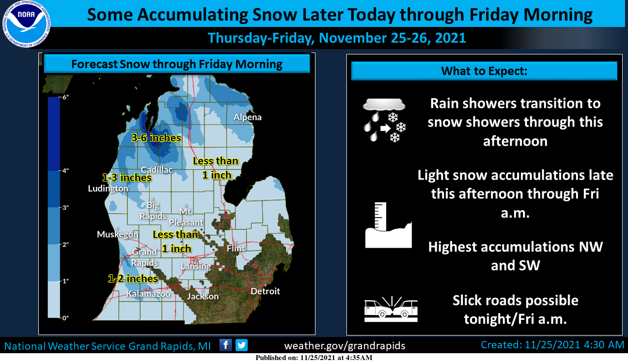
With the exception of northern New England, all is quiet weather-wise in the U.S. We have a few light showers passing through the area this morning which will transition over to snow showers this afternoon as temperatures fall through the day. Some light accumulations of an inch or two of snow are likely tonight toward Ludington and SW of Grand Rapids. Another round of light snow could bring some snow accumulations to much of the area late Saturday and Saturday Night.
Forecast Discussion
- Light rain showers to light snow showers later today -

KGRR/rgnl radar trends early this morning corroborated with a
consensus of latest higher res short range guidance all suggest
that light rain showers will continue to develop across our
southern fcst area through the early to mid morning hours until
fropa occurs.

Brisk nw flow caa after fropa will cause temps to fall through the
30s this afternoon. NW flow light lake effect snow showers will
develop as h8 temps plummet to around -9 to -11 C by 00Z Fri.
However low inversion heights and shallow moisture will
significantly limit les potential. Therefore we only expect light
snow accumulations of around an inch or less in our favored nw
flow snow belt regions from this aftn through early Fri.

Lingering light lake effect snow showers early Friday will taper
off as h8 temps moderate Friday and ridging moves in from the
west. Dry/fair wx is expected with the ridge in place Friday night
into Saturday morning.

- Light snow late Saturday into Sunday -

A clipper system will move in from the nw and bring synoptic light
snow late Saturday through Saturday night into Sunday. It is noted
that the 00Z ECMWF deterministic run brings the clipper in a
little faster and further north. Given latest trends it now seems
that light snow may already begin to develop Saturday afternoon
(rather than holding off until Saturday night).

It is also noted that overall guidance trends are just a bit more
aggressive with the snow potential with this clipper system. The
most likely outcome is for our area to get anywhere from a few
tenths of an inch to around two inches of snow from Saturday
afternoon through Sunday. We wouldn`t rule out localized higher
amounts to near three inches given some moisture enhancement from
Lake MI.

A consensus of latest medium range guidance suggests that
seasonably cold wx will continue from early to mid next week.
Ecmwf/gefs ensembles suggest that temps will moderate a bit for
late next week.
The snow just keeps coming!
Happy Thanksgiving MV’s best enjoy this wintery Thanksgiving day….InDY….
The cold and snow just keeps coming! Snow this afternoon, snow Saturday afternoon, snow Saturday night and then below normal temps most of next week! Great start to winter this year! Let’s keep it rocking!
+100….InDY
HAPPY THANKSGIVING EVERYONE!!
Happy Thanksgiving and my advise is avoid any unvaccinated guests! My rule is: I will not allow anyone into my home that is unvaccinated, other than children under the age of 5 years old!
Happy Thanksgiving. Just 0.01″ of rain fall here so far today. The overnight low was 44 and the current temperature with cloudy skies is 45. Last year Thanksgiving’s H/L was 45/40.
Slim
Get ready for the clipper on Saturday night! The cold and snow just keeps coming!