First off, I will take a look at the weather history for Halloween. At Grand Rapids the average high/low for Halloween is 54/38. The record high of 79 was set in 1950, it has reached 70 or better in 10 years, the last time was in 1981. The coldest maximum of 32 was set in 1917. There have been 5 years when the high did not reach 40 the last time was in 1996. There have been 7 years with a high of 40 the last time was 1995. 1917 was the year that seen the most snow fall at Grand Rapids when 1.5” fell, 0.4” fell 100 years later in 2017 that was the last time it snowed on the 31st The record low of 20 was set in 1988. As that would be the morning low The low on November 1st was 36 so it may not have been that bad for trick or treating. A low of 21 was recorded in 1976 on November 1st so that was a cold night of trick or treating. The wettest was 1.27” of rain in 1994 and there was 1.21” of rain in 2013. Last year it was 59/49 with 0.09” of rain. While it is several days away there still looks to be at least a chance of some snow in the air this year for Halloween we shall see.
November is the last of the “Fall” months and it can at times be close to a winter month. The average H/L starts out at 53.6/37.8 and falls to 41.0/28.6 by the 30th. The warmest mean for November is 47.6 in 1931 and the coldest mean is 31.0 in 1951. The record high for the month is 81 on November 1st, 1950, and just 25 days later the low fell all the way down to -10° November 1950 for the record low. November 1950 had a spread of 90° that is the biggest temperature spread of any month at Grand Rapids. On average 7.4” of snow falls in November. The most snow fall is the 31.0” that fell in November 2014. There was no snow fall in 1906 and 1907 for the least amount of snow fall. The average rain/melted snow fall is 2.48” the most for the month is 7.90” fell the least was just 0.06” in 1904. Last year November was a wild month. The mean for November was 40.9° that was a departure of +0.9. There was 2.33” of rain/melted snow. But the month had a record daily high set on the 10th of 75. The low for the month was 18 set on the 19th, 20th, and 22nd. For the month there was 28.0” of snow fall, that is the 2nd most for any November. Daily record snow falls were recorded on the 19th (8.7”) and the 17th (7.6”) and a 2nd place total of 7.0” on the 17th. Now we can sit back and see how Halloween and November 2023 will play out. ‘
The official H/L at Grand Rapids yesterday was a warm 68/50. There were 6 HDD’s there was 0.08” of rain fall and just 1% of possible sunshine. October has been a rather wet month as there now has been 5.27” for the year Grand Rapids is now up to 32.94” and that is still -0.37” below average as of this date. There was no snowfall yesterday. For today the average H/L is now 55/38 the record high for today is 74 set in 1989 and the record low of 23 was set in 1965 and 1969. The record rain fall of 0.84” fell in 1899. The record snowfall of 3.5” fell in 1925. Last year the H/L was 59/34.
AREA FORECAST DISCUSSION
NATIONAL WEATHER SERVICE GRAND RAPIDS MI
415 AM EDT SAT OCT 28 2023
LATEST UPDATE…
SHORT TERM/LONG TERM/MARINE
SHORT TERM
(TODAY THROUGH SUNDAY)
ISSUED AT 414 AM EDT SAT OCT 28 2023
– THE COLD FRONT ARRIVES
GUSTY NORTHWESTERLY WINDS HAVE ARRIVED AND WILL USHER IN COOLER
TEMPERATURES INTO THE REGION TODAY. 850MB TEMPS ARE AROUND 04C SO
EXPECT HIGHS IN THE UPPER 40S TO LOW 50S. THE GUSTY WINDS HOWEVER
WILL MAKE IT FEEL QUITE CHILLY WITH WIND CHILLS IN THE LOW 40S.
LOWS TONIGHT INTO SUNDAY WILL BE NEAR FREEZING ALONG THE US 10
CORRIDOR AND IN THE UPPER 30S TO LOW 40S ELSEWHERE.
A DEEPENING TROUGH WILL EXTEND ACROSS THE UPPER MIDWEST SOUTHWARD
ACROSS THE INTERMOUNTAIN WEST. THAT TROUGH WILL MOVE EASTWARD
TONIGHT INTO TOMORROW. THIS WILL BRING THE CHANCE FOR ANOTHER
CHANCE FOR SHOWERS WITH THE BEST CHANCE ALONG AND SOUTH OF THE I
94 CORRIDOR. THE PRECIPITATION CHANCES WILL CONTINUE INTO SUNDAY
NIGHT WHICH WILL BE DISCUSSED BELOW.
LONG TERM
(SUNDAY NIGHT THROUGH FRIDAY)
ISSUED AT 414 AM EDT SAT OCT 28 2023
– LINGERING RAIN SUNDAY NIGHT, FIRST SNOW FOR HALLOWEEN
CHANCES FOR SHOWERS (40 TO 60 PERCENT) CONTINUE SUNDAY NIGHT INTO
MONDAY MORNING AS UPPER LEVEL DIVERGENCE AND 500MB POSITIVE VORTICITY
ADVECTION MOVE THROUGH THE AREA. DRIER CONDITIONS MOVE IN DURING THE
DAY MONDAY BUT THIS WILL BE SHORT LIVED AS AN UPPER LEVEL TROUGH AND
SURFACE FRONT MOVE THROUGH TUESDAY. MOTHER NATURE WILL SURE BE
PLAYING SOME TRICKS ON US FOR HALLOWEEN WITH THIS SYSTEM AS
TEMPERATURE PROFILES WILL BE COLD ENOUGH FOR SNOW. AT THIS TIME NBM
PROBABILITIES AND ENSEMBLE GUIDANCE SHOW LIGHT SNOW AMOUNTS AND ANY
ACCUMULATIONS WOULD BY MORE LIKELY ON GRASSY SURFACES. THE TROUGH
CLEARS TUESDAY NIGHT WITH A BRIEF RIDGE FILLING IN FOR WEDNESDAY
INTO THURSDAY. ANOTHER SHORTWAVE TROUGH MOVES IN THURSDAY NIGHT, BUT
COULD JUST BRING SOME INCREASED CLOUD COVER. HEADING INTO NEXT
WEEKEND THERE IS MORE UNCERTAINTY WITH THE TIMING OF ANOTHER
SHORTWAVE SO JUST HAVE SOME LOWER END POPS FOR NOW (MAINLY 20 TO 30
PERCENT).
TEMPERATURES DURING THIS TIME WILL BE A BIT COOLER WITH HIGHS IN THE
30S TO LOW 40S AND LOWS IN THE 20S. TOWARD NEXT WEEKEND TEMPERATURES
INCREASE A LITTLE AS WARM AIR ADVECTION SETS UP OVER THE AREA.
Detailed Forecast For Grand Rapids
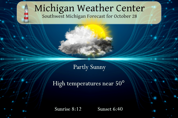
Today
Partly sunny, with a high near 50. North wind around 9 mph.
Tonight
Showers likely, mainly after 2am. Mostly cloudy, with a low around 41. North northeast wind around 7 mph. Chance of precipitation is 60%. New precipitation amounts of less than a tenth of an inch possible.
Sunday
Showers likely, mainly after 2pm. Cloudy, with a high near 46. Northeast wind around 7 mph. Chance of precipitation is 60%. New precipitation amounts of less than a tenth of an inch possible.
Sunday Night
Showers likely, mainly before 2am. Mostly cloudy, with a low around 33. Northwest wind around 7 mph. Chance of precipitation is 60%. New precipitation amounts of less than a tenth of an inch possible.
Monday
A 30 percent chance of showers before 8am. Partly sunny, with a high near 39. West northwest wind 5 to 15 mph, with gusts as high as 23 mph.
Monday Night
Mostly cloudy, with a low around 32.
Tuesday
Snow showers likely after 8am. Mostly cloudy, with a high near 38. Chance of precipitation is 70%.
Tuesday Night
A chance of snow showers before 2am. Partly cloudy, with a low around 25.
Wednesday
Mostly sunny, with a high near 41.
Wednesday Night
Partly cloudy, with a low around 30.
Thursday
Partly sunny, with a high near 45.
Thursday Night
Mostly cloudy, with a low around 35.
Friday
Mostly cloudy, with a high near 49.
SNOW!
https://weatherstreet.com/models/gfs-acc-snow-forecast.php
Great weather this week. We sat out back last night and enjoyed a couple of adult beverages. It began to sprinkle so we went inside. We then had a couple of flashes of lightning — and it’s nearly November. That’s crazy.
Can you say, lows in the mid 20’s? Wow, just wow, wow!
Halloween this year = COLD with SNOW showers! Incredible cold is coming to a neighborhood near you! Get ready!