In 1976 I still worked and lived in the Bay City area. I was at work on the night of the start of the biggest ice storm to hit much of Michigan.
The great ice storm struck Lower Michigan on March 2nd and 3rd 1976. The ice storm is still the worst widespread ice storm in Michigan’s weather records.
It was actually a very strange weather situation. In looking back, part of Lower Michigan had heavy ice accumulation on March 2-3, 1976, while other parts of Lower Michigan had thick ice build up on March 4, 1976.
There were reports of three inches of ice accumulation in part of Lower Michigan.
The heaviest area of ice looks like it stretched from west to east across all of central Lower Michigan. The hardest hit stretch was Muskegon and Grand Rapids east to Saginaw, Bay City and the Thumb.
I left for work on March 2nd with very heavy snow falling and a strong NE wind coming off of the Bay. At Bay City we had around 6” of snow before the snow changed to freezing rain. Between 6Pm and 10PM there were several thunderstorms of freezing rain and high winds. The power went out at around 8MP but we stayed at work because it was just too bad to leave. Saginaw had 4″ of wet snow on March 2, 1976 and then 1.8″ of freezing rain accumulation. March 3, 1976 Saginaw had .45″ of freezing rain. Even March 4, 1976 may have had up to .50″ of additional freezing rain. Caro, in the Thumb, had 3.3″ of liquid fall between March 2-3, 1976. About .50″ of that moisture was snow, so 2.8″ of ice probably accumulated.
Grand Rapids had over 2.8″ of liquid fall between March 1, 1976 and March 4, 1976. Most of that rain fell with temperatures below freezing, meaning ice accumulation.
Muskegon’s weather was pretty crazy. 2″ of ice fell on March 2, 1976 and another 1″ of freezing rain fell on March 4, 1976.
Even far southern Lower Michigan had some ice accumulation. It looks like between .50″ and 1″ of ice was common.
It’s just rare that Michigan’s temperatures can remain in a range that produces freezing rain for a long period. Usually, it warms up and changes to rain fairly quickly, or changes to snow.
I hope we do not have to deal with another ice storm of the magnitude, but I also know that we are way overdue.
With the mild temperatures expected today lest put things into proscriptive. This weekend looks to be very mild and windy. There will be a cool down to near average early next week and then a chance of a very big cool down around next weekend. That cool down could be rather cold but that should be the coldest we see until next winter season. The reason for that is even when it is well below average after mid-March the averages are then higher, so days of extreme cold are somewhat rarer. But it still can get very cold. At Grand Rapids it has gotten below zero as late as March 25 and it has gotten as low a +8 as late as April 8th. On the flip side the fist day of 70+ was 72 on March 3rd and as warm as 80+ on March 12th and as warm as 85+ on March 21st the earliest 90 day was on April 29th.
Slim
The 10 day storm track is coming right at us! Incredible!
https://www.pivotalweather.com/model.php?m=gfs&p=sn10_acc&rh=2022030600&fh=240&r=conus&dpdt=&mc=
I must be dreaming, March 6th and a WWA is imminent and then colder than normal temps the rest of the month! Wow, just wow!
Mid 60’s at 1130pm? I must be dreaming!
It was warmer than expected here today when it reached 63. Can’t ask for much nicer weather for early March.
Enjoy your one warm day, because that is it for awhile!
It feels incredible outside this evening. I’m looking foreword to when this is here to stay.
The next week looks to be average to above average temps.
Get ready by the end of next week, cold, cold, cold!!!!!
Tornado approaching the Des Moines, IA suburbs. Not good.
…A TORNADO WARNING REMAINS IN EFFECT UNTIL 515 PM CST FOR
SOUTHWESTERN POLK…NORTHEASTERN MADISON…SOUTHEASTERN DALLAS AND
NORTHERN WARREN COUNTIES…
At 451 PM CST, a confirmed large and extremely dangerous tornado was
located 7 miles northwest of Avenue Of The Saints Event Center, or 8
miles east of Winterset, moving northeast at 45 mph.
This is a PARTICULARLY DANGEROUS SITUATION. TAKE COVER NOW!
And it was warmer here than Des Moines today. Go figure.
I see 32 degrees currently in MI! Wow!
I loving the long range snow maps!
https://www.pivotalweather.com/model.php?p=snku_acc&fh=384
I see cold and accumulating snow in the forecast! Incredible!
I see 70 degrees in SW Michigan. Wow!
I see golfers out!
Ice storms are the worst. The ice storm you describe didn’t touch us down here in the Kazoo area as I recall. However, the ice storm that hit us in Jan. of 1985 was just about as awful as your’s. I copied this description from your weather history post on Jan. 1, 2020: “1985: A severe ice storm struck southern Lower Michigan as a layer of ice up to one inch thick downed tree limbs and power lines. There were three deaths and eight injuries directly related to the ice storm. Over 430,000 electrical customers were without power, some for… Read more »
That’s the one I remember. It was very icy!!!
Enjoy this warm winter day, because after today we will transition to a cold wet and snowy month! It is going to brutal for the warm weather nuts! Get prepared now!
I’m seeing upper 60’s in Michigan! Can we hit 70 degrees?
Thanks Slim! I vaguely remember that storm. I would have been only 6, but I do remember trying to traverse our yard without much success because of the solid ice (our property has a lot of hills). Another bright sunny day today and just a touch above average at 65 degrees (+25!?).
The latest EURO model is getting bullish for accumulating snow the beginning of next week! How is that possible because mookie says all rain and the snow is hundreds of miles away?
https://www.pivotalweather.com/model.php?m=ecmwf_full&p=sn10_acc&rh=2022030512&fh=108
NWS GRR says 0.5-1.5” of snow on the backside. A regular “snowstorm” for Rocky LOL
The great news just keeps coming! Snow county is looking GREAT for skiing for many more weeks! Who would have thought? Absolutely INCREDIBLE!
https://www.pivotalweather.com/model.php?p=snku_acc&rh=2022030512&fh=330
All the snow is hundreds of miles north. That is great news!
Wow 50’s before noon! And the big “snowstorm” looks to be mainly rain now. I love it!
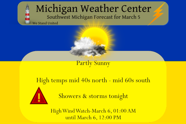
High Wind Warning for all of us: 1133 AM EST Sat Mar 5 2022 …HIGH WIND WARNING IN EFFECT FROM MIDNIGHT TONIGHT TO 1 PM EST SUNDAY… * WHAT…Southwest winds 25 to 35 mph with gusts to around 60 mph expected. * WHERE…Portions of central, south central, southwest and west central Michigan. * WHEN…From midnight tonight to 1 PM EST Sunday. * IMPACTS…Damaging winds will blow down trees and power lines. Widespread power outages are expected. Travel will be difficult, especially for high profile vehicles. * ADDITIONAL DETAILS…Two separate bursts of wind are expected across the area. The first sweeping… Read more »
Great info Slim. The most damaging ice storm I can remember in my lifetime was 2013. Ice accumulations were very significant. I remember walking out on the porch in the morning hearing trees popping and crashing in the woods. No power for I believe 5 days. Lots of people southeast of GR had no power Christmas Day 2013 (Us included) as the storm hit the 21st into the 22nd.
Same here. We lived at my sister-in-law’s for Christmas. It was one of our most memorable Christmases. Our kids had a ball with their cousins.
Forecast Discussion: Warm front lifts through lower MI mid to late morning setting up strong WAA across west MI. While this strong WAA leads to a breezy afternoon/evening, warm nose in the 850-900mb layer greatly limits any potential mixing down of 40+kt winds at/above 800mb, with afternoon wind gusts only topping out around 20-25mph. Some degree of clearing is expected this afternoon once the front fully clears the area, with best potential mostly sunny skies being along the I- 94 corridor. As a result, these areas have a good shot of seeing highs in the low 60s today. Will be… Read more »
Hazardous Weather Outlook For Michigan:
.DAY ONE…Today and Tonight
Showers and thunderstorms could bring strong wind gusts (up to
50-60mph) late tonight. A High Wind Watch remains in effect
tonight into Sunday as a result. Scattered power outages are
possible.
.DAYS TWO THROUGH SEVEN…Sunday through Friday
A strong cold front sweeps across the area Sunday morning bringing
the best potential for strong wind gusts of 50-60mph. A High Wind
Watch remains in effect through noon Sunday. Scattered power
outages are possible.
SPC Convective Outlook :

Severe thunderstorms are possible this afternoon through tonight
across the lower Missouri Valley into southern portions of the Great
Lakes region. This may include the risk for large hail and a few
tornadoes across parts of western into central Iowa and northern
Missouri, with damaging winds also possible elsewhere across the
region.
Our first Marginal risk of 2022
Breaking news>>>>>the latest CPC is a thing of beauty! Colder than normal temps and above normal precip! How could it be after all the warm weather nuts said above normal temps and warm Springs temps are right around the corner? Happens every year like clockwork! I love it!