We definitely have more than a breezy morning. The wind is howling with a few sprinkles and a temp of 52° at 6 am. We don’t get good wind readings down here in the valley but our highest gust was 20 mph so far. If I went up to the city I am sure gusts would be around 50 mph or better. Yesterday we had a high temp of 67°! Our low was 34°.
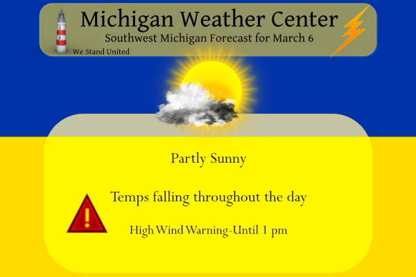
We can expect partly sunny skies today, with temperatures falling to around 41 by 9 am. Windy, with a west southwest wind of 18 to 23 mph increasing to 25 to 30 mph in the morning. Winds could gust as high as 55 mph. Rain chances increase once again after midnight, rain will change to snow as temps fall into the 30s. I don’t expect to see more than an inch or two tonight and tomorrow.
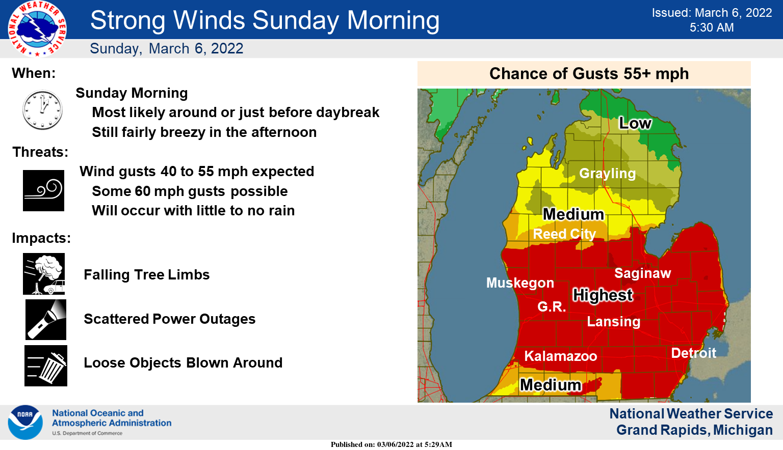
A few hours of strong wind gusts of 40-55 mph and some spots of 60 mph will likely occur in a wide section of the central-southern Lower Peninsula around or after daybreak. It will gradually become less windy going into the afternoon, but it will still be fairly breezy until sunset. Temperatures will fall into the 40s and 30s during the day.
Forecast Discussion
- Gusty winds still expected today

We will be keeping the High Wind Warning up as it is with the
forecast package this morning.

The first round of wind has worked its way through most of the area
as of 08z this morning, with it only having the SE corner of the
CWFA to move through yet. Wind gusts were on the order of 45 to 65
mph. The High wind warning covered this well, as it was a bit more
prolonged as compared to a pure Severe Thunderstorm. The line of
showers and embedded thunder helped mix it to the ground some, but
the strong winds just off of the surface were the main factor.

We will see a brief break in the wind for the next couple of hours,
before the next round moves over the area. This is evident on the
sfc map with areas across SW Wisconsin seeing wind gusts approaching
50 knots with the surge of the colder air supporting that, and 50-55
knots around 2-3k ft. It appears that the second surge of wind will
start to show up at the lakeshore by 10z, and then spread ENE
quickly after that. The winds aloft will then gradually taper off
starting mid-morning.

- Wintry weather expected early Monday

We will only see a brief break in impactful weather Sunday evening,
before some wintry precipitation moves in over most of the area by
daybreak on Monday.

The upper low that is over Srn NV early this morning will be opening
up and lifting to the NE toward the area. The associated sfc low is
expected to move just north of the Ohio River. We will see most of
our pcpn be the product of some initial upper jet coupling, and then
shifting to the deformation zone of the upper wave.

Pcpn should be mainly snow for most of the area, for most of the
event. The exception to this will be some potential light rain, or
even freezing rain on the front side of the event down toward
Jackson. The thermal profile will have a thin layer of some above
freezing air thick enough for some liquid. The question then is the
sfc temps which will dictate rain or freezing rain. Not a lot of
margin for error with that, so we will go with a mix for now, and
fine tune it more later today.

The highest amounts from this system will be up north, where sfc
temps will be cooler, the forcing is better, and where SLRs will be
a bit higher. We think that there is a good chance much of, if not
the entire CWFA may need an advisory with impacts expected around
the Mon morning commute. This will come to an end on Monday
afternoon. There may be just a little lingering lake effect later
Monday and Monday night, but it should not add up to much and will
end Monday night as the upper trough passes through.

- Another round of wintry weather late in the week followed by cold

We will actually see a fairly tranquil period after the Monday
event, with moderating temperatures through Thursday. We get into a
fairly zonal upper flow pattern, with the stronger waves and the
upper jet staying north of the area. A weak front does look to drop
down around the Wednesday time frame, but this will not have any
moisture to work with.

We will see the upper pattern reload to our west by Friday as a long
wave upper trough digs over most of the Plains. Eventually, we will
see energy round the base of the trough and lift NE toward the area.

The details of the timing of precipitation are a bit uncertain as is
typical with short waves ejecting from a long wave trough. It does
appear that multiple waves could impact the area for Friday and
beyond. This all taking place will be part of the transition to the
trough moving overhead, and bringing colder than average weather
back to the area next weekend.
What more snow?? No way ….InDY..
Did someone say winter is not over yet?
https://www.pivotalweather.com/model.php?m=ecmwf_full&p=sn10_acc&rh=2022030612&fh=240
Winter Weather advisory in March??? No way …InDY
What you mean winter is not over? What you mean we won’t see warm Spring temps all month! Who would have thought?
A WWA had been issued for 2 to 4 inches of snow! Who knew? Certainly not mookie who said all rain! The RDB model ROCKS! Incredible!
If this storm actually pans out, then we would have had a good snow in mid-November and mid-March, a good 4 month period. I’m definitely ready for spring though! (Also power is back on 😀)
Glad your power is back and yes this has been a cold and snowy winter and winter is surely not done yet!
>>>>BREAKING WEATHER-ALERT>>>>the 12z RDB model gives GR 2-4 inches of snow by tomorrow night! Get prepared now!
Another wind event, 2 more trees down. One right across our driveway. At least the power stayed on this time. Seems the past 6-9 months we’ve had way more than our share of high wind events? Top wind gust on my PWS was 57mph but I think that was a bit low.
I lost my power a couple of times for short periods. One longer time when we went to bed. The wind was very strong when it came thru. I think it was above 60 mph. The noise from it was loud.
The latest EURO is looking good for snow tonight/tomorrow! Rock n roll will never die! Bring it!
https://www.pivotalweather.com/model.php?m=ecmwf_full&p=sn10_acc&rh=2022030612&fh=48
Winter Weather advisory no way….InDY
Get ready to rock! Happens every year Indy! The warm weather nuts have one day with nice temps and they think winter is over! Too funny!
Especially when it snows more ..lol..InDY
Out of power here…
Oh boy, hopefully not for long!
The cold front has gone thu here and the temperatures has dropped down to 39 here. The highest gust at Grand Rapids was 56 MPH. There was a total of 0.14″ of rain fall here and there were a few flashes of lightning last night. The high here was 64 yesterday that is the 2nd warmest it has ever been on March 5 here in Grand Rapids. At Muskegon they set a new record high of 68.
Slim
As of 8am, the Kalamazoo/Battle Creek International Airport has recorded wind gusts up to around 40 mph. So, only winds around the bottom of those forecast. Glad we didn’t see 50+ mph winds.
Wow, the updated CPC gives us below normal temps the rest of this
Month! It has definitely been a cold winter! Incredible!
It appears that the NWS does not agree with the CPC for the next week, at least.
Next week is the transition week, some below, some normal and maybe a couple slightly above!
LOL You’ve been saying that for weeks. 6 out of the last 7 days were 40-64 degrees, and this week will be average to slightly above average temps.
Lol, you are clueless!
Felt like a summer night last night! Back to back 60+ degree days in early March. Wow!
Wow!! windy, temps dropping like a rock, accumulating snow developing, slippery roads, below normal temps for the at least the next 2 weeks! Can you say it is still winter people! Forget warm Spring weather and embrace the last few weeks of winter! Rock n roll will never die! Who loves winter?