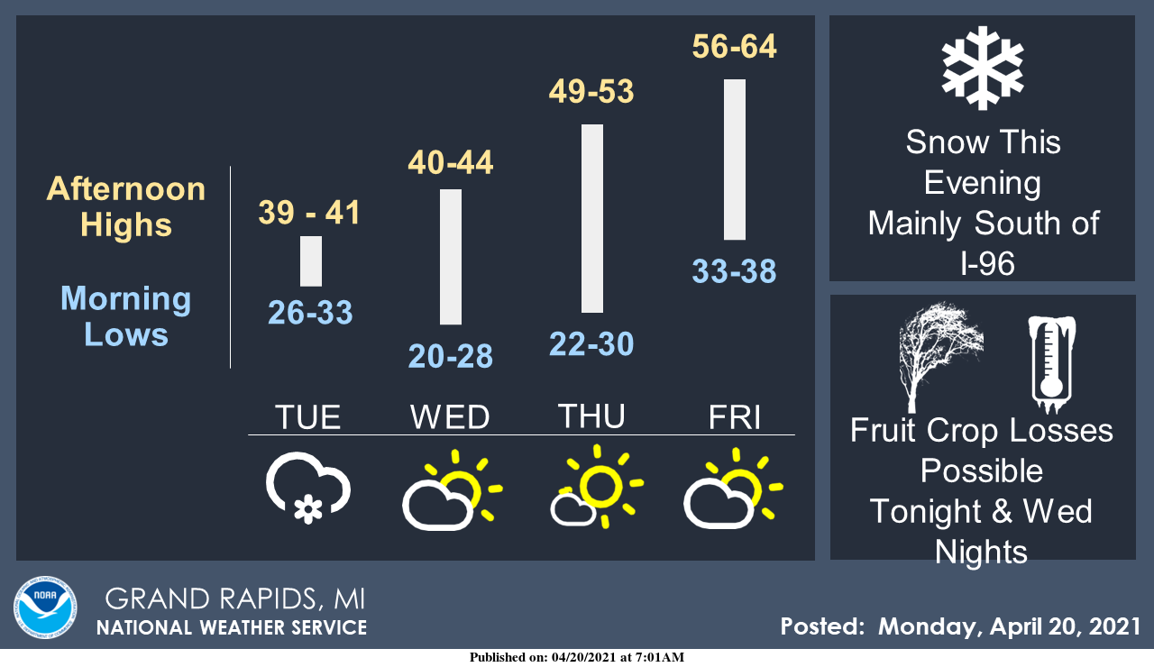
The main story for this week is the freeze warnings covering all of Michigan. Snow is expected to accumulate to 1 to 3 inches in the I-69 area later this afternoon into early tonight. The heavier snow amounts will be near I-80 in Indiana and Ohio. The more significant story will be the freezing temperatures tonight and Wednesday night. Fruit tree blossoms are ahead of schedule after the warm weather several weeks ago and will be damaged by temperatures dropping into the 20s. We will have to see how this affects the leaves which have begun to come out on the trees.
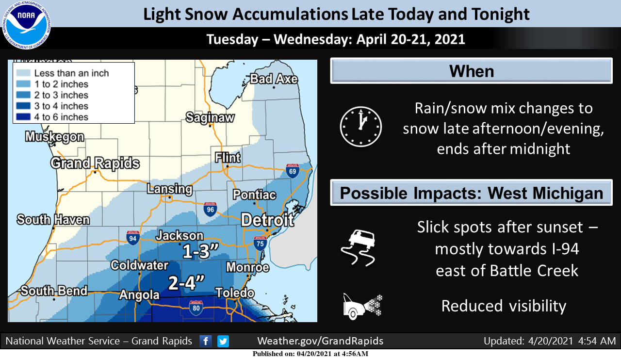
This is the current snowfall forecast:
Forecast Discussion:
-Widespread hard freeze expected Tuesday and Wednesday nights

More cold air will get pulled down into Michigan by Tuesday night
as low pressure passes to our Southeast. Latest guidance
continues to strongly support a widespread hard freeze across the
entire area Tuesday night as temperatures fall into the low and
mid 20s. Temperatures look to recover only a few degrees by
Wednesday night, making another hard freeze likely for most of
the area under light winds and mostly clear skies. The exception
Wednesday night could be near Lake Michigan, where light west
winds off the Lake look to hold temperatures in the low 30s for
minimums. Warmer temperatures above freezing are expected Thursday
night through the weekend.

Cold low temperatures forecast for Tuesday night/Wednesday morning
are well below normal (about 40 degrees), but at this time look
o be several degrees shy of records (22 in Grand Rapids, 15 for
Lansing, 23 for Muskegon, and 20 at Kalamazoo). Thursday morning
looks similar with forecast low temperatures above records (24 in
Grand Rapids, 21 for Lansing, 22 for Muskegon and Kalamazoo).

-Chance for accumulating snow shifts mostly southeast of the area

Taken as a whole, models over the past 24 hours have continued to
trend slightly more to the southeast with the track of a low
pressure system and the swath of accumulating snow in the
deformation zone on the north side of the low track. Latest
consensus takes it up through the far southern Ohio Valley, and
keeps the heaviest snow accumulations over Ohio, with perhaps
several inches of accumulation leaking into extreme Southeast
Michigan. Models now keep almost all of the precipitation south of
a line from South Haven to the Lansing area, but cant rule out a
few light snow showers or flurries north of there (including Grand
Rapids).

Precipitation will spread into the area during the afternoon
and may initially start out as rain with temperatures in the low
40s, but wet-bulb effects due to dew points only in the 20s and
falling temperatures will force a changeover to snow during the
late afternoon and evening. Snow will be more effective at
accumulating on elevated surfaces due to the warm ground
temperatures. We are a little uncertain on how much impact we will
see on roads prior to sunset around 830 PM, as pavement
temperatures will be at their diurnal peak as snow gets underway,
air temperatures will only fall to near freezing while it is
snowing, and the higher snowfall rates we will need to overcome
these limitations may stay to our southeast. Accumulations on
roads will be more likely after the sun sets, but if the roads
remain wet from afternoon/evening snow or are treated (easy to do
with air temperatures near freezing), it may be hard to get snow
to stick even then. Snow should slide east of the area after
midnight Wednesday morning. Although precipitation will be
finished as the morning commute gets underway, drivers should
still watch for slick spots.

For our forecast area, best chance to see an inch or two of slushy
snow accumulation (mostly on light-colored or elevated surfaces)
and slick spots on roads will be over Jackson County and perhaps
into Calhoun County. No advisories will be issued with the morning
forecast package given potential limitations to travel impacts
and for swath of accumulating snow to shift still further
southeast. We will continue to watch model trends today, and could
still issue a quick advisory if things start to look different or
if we start to see more support for snowfall rates high enough to
accumulate on pavement.

-Temperatures recover for the end of the week

Upper trough will move east of the area and be replaced by ridging
by Thursday night. Although we will see a few quick waves pass
through the area late this week, they should not have a dramatic
impact on temperatures. Following high temperatures today and
Wednesday only in the low 40s, we expect to see readings rebound
to the 50s to low 60s for Friday and the weekend.
36* degrees already outside in my area how low will we go January cold ?? Stay tuned! INDY
34 here right now. I hope not too cold tonight and tomorrow night. I am concerned for the farmers.
I don’t think we hit 40 here today. This has been a crazy month. We’ve seen days at +20 and -20.
Snowflakes are falling from the sky right now.
Freeze warning for the next 2 days! Wow what a cold stretch!
The Tigers baseball game has been cancelled due to accumulating SNOW! Incredible considering we are approaching late April!
Get ready for the extreme cold!
The overnight low here was 29. It looks like the official overnight low at the airport was 32. At this time it is cloudy and 35 here.
Slim
Hoping for a bumper fruit crop this year. 😋