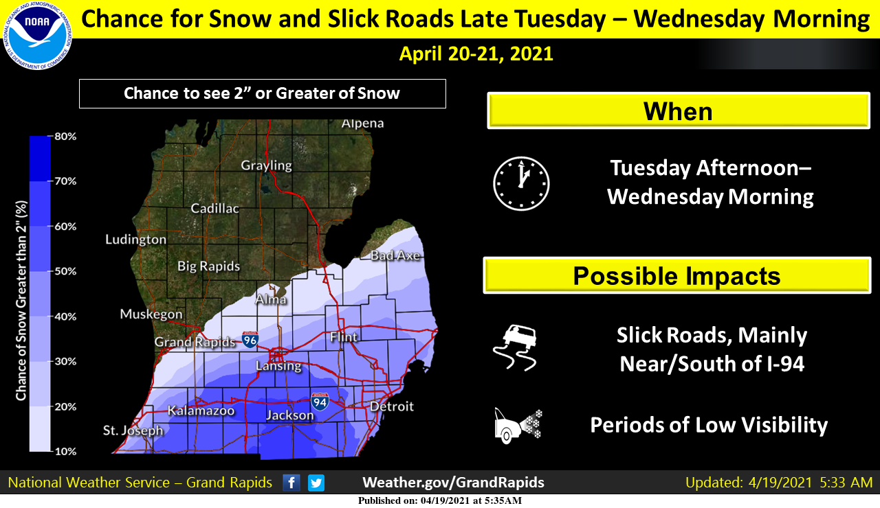
At this time the projected path of our Tuesday storm system bringing snow to the area has moved further south. Grand Rapids won’t see much more than an inch (or less) while Kalamazoo is forecast to get around three inches of the white stuff. Point forecasts are showing a couple of inches for Lansing and an inch for Flint. Keep in mind these are only guesses assuming the current storm track stays on course.
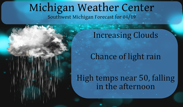
We will see a downward trend in temperatures beginning this afternoon as a cold front passes through bringing with it a chance of light rain or sprinkles – not much moisture attached to this front, a few hundredths at best.
There is a freeze watch for most of the area for tomorrow night through Thursday morning as temps drop into the 20s which doesn’t bode well for fruit trees that have begun budding.
Forecast Discussion
- Cold front will bring rain showers and cooler temperatures today

Water vapor imagery this morning shows an impressive shortwave
dropping through Wisconsin. This wave will push an area of low
pressure across Northern Michigan and drive a strong cold front
through the area this morning and afternoon. A band of showers has
been aligned along and behind the front this morning as it
approaches, in part supported by a weak low-level jet. Expect to see
the coverage and intensity of the rain showers diminish a little by
late morning as we lose lower jet support. This would place the best
coverage of showers for our area from the Grand Rapids area north
and west. Overall, we will see plenty of clouds today, modestly
gusty winds to around 25 mph, and temperatures falling behind the
front in the afternoon. Highs will vary widely across the area and
depend on timing of the frontal passage, with the warmest readings
near Jackson/Lansing/Battle Creek in the mid and upper 50s to only
the mid 40s near the US 10 corridor.

We may see another flare-up of showers along the front just before
it departs the area late this afternoon and evening as more
favorable upper jet forcing arrives. This would mainly affect areas
from I-94 southward. A few showers will remain possible overnight,
mainly south of I-94, closer to the frontal boundary as it settles
into the Ohio Valley.

- Forecast for accumulating snow continues to shift Southeast

Upper energy digging into the Central Plains and Midwest will send
an area of low pressure up through the Ohio Valley Tuesday and
Tuesday night. By this time, the strong cold front that will pass
through Michigan today will have settled into Indiana and Ohio,
placing us solidly within a much colder/drier airmass and setting
the stage for any precipitation to fall as snow, possibly as early
as Tuesday afternoon given low dewpoints and good potential for wet-
bulbing. The eventual placement of the cold front is vital to
determining where snow will fall and travel impacts will be felt.
While models are still not in the best agreement with where the
front settles, the overall trend with the 00Z models coming in has
been to shift the front and axis of precipitation southward. 19.00Z
GFS is currently the furthest south (as of 3 AM) and shows only a
little bit of snow now south of I-94. Other operational runs like
the Euro and the Canadian are still holding onto light snow
accumulations near the I-94 corridor and into Southeast Michigan,
while other models like the NAM and higher-res runs like the HRRR
and ARW hint at at least light accumulations as far north as I-96.
Snow forecast still hangs onto some lighter accumulations as far
north as I-96, but confidence in this occurring is not high at this
time given model trends. Will continue to watch this play out over
the next couple of cycles, but still watching for potential for
several inches of slushy accumulation and slick conditions
developing, particularly along the I-94 corridor.

- Threat for frost and freezing conditions multiple nights this week

The return of cold weather may end up being the biggest weather
story of the week, as we may see significant damage to fruit crops
as temperatures fall into the 20s several nights in a row. As a
reminder, Frost Advisories will not be issued until May 1 and Freeze
Warnings are still not being issued for Osceola, Clare, Mecosta, and
Isabella Counties where crops have not progressed as far as in other
parts of Western and Central Michigan. Frost and Freeze headlines
are mainly aimed at commercial growers, and any home gardeners in
West Michigan who have started their gardens or have flowers outside
will need to take measures to protect them most nights this week.

Concern for damage begins tonight over Central Michigan as we see
temperatures fall to the mid 20s to low 30s. The first Freeze
Warning of the week will be issued with the morning forecast
package, covering Mason, Lake, Oceana and Newaygo Counties. Of
bigger concern will be temperatures falling solidly into low/mid 20s
Tuesday night. This looks to be followed by low temperatures in the
20s Wednesday night as well, although counties adjacent to Lake
Michigan may squeak by as flow turns off warmer Lake Michigan and
lows only drop to near freezing. To cover the potential for a hard
freeze two nights in a row, a single Freeze Watch will be issued for
the morning package to cover all of the area where the growing
season has gotten underway for both Tuesday and Wednesday nights.
Overnight temperatures should be warmer on Thursday, but we may
still see areas of frost for areas well inland of Lake Michigan.
Incredible cold is coming! Get prepared now!
What an absolutely incredible late April 10 day snow map across the country! This month is turning out to be cold and snowy! Who would have thought?
https://www.pivotalweather.com/model.php?m=gfs&p=sn10_acc&rh=2021041918&fh=288&r=conus&dpdt=&mc=
And even more incredible that most of Michigan, including all of us, is painted white which equals ZERO snow! Tremendous pattern!
Frost and Frezzee watchs warnings out for overnight prey for the farmers of Michigan this maybe devastating to there crop ….I feel for my beautiful lilac bush out back ….INDY
Hey INDY, you should cover your bush with an old bed sheet these next few nights. That would protect it.
During late winter or early spring, if a harsh freeze comes along, you may need to cover your shrub to protect the new buds. You can use a blanket, plastic tent, or burlap.
All ready did I have 3 sheets around it …I’m hoping that will help I even put hay around the bottom of it cross my fingers …Thanks for the info Stay tuned I wll be paying attention to the temperature all night ..INDY
Sounds good! The hardy plants should be good tonight, it’s tomorrow night and Wednesday night that could be bad with the freeze around here.
There was a total of 0.17″ of rain here with the cold front that came thru. The official rain fall was 0.12″ at the airport. The high here for the day was 51 and at GRR the high looks to have been 53. At this time it is mostly cloudy and 45 here and 43 at the airport.
Slim
Maybe we won’t see any snow? From the NWS GR 11:30 update:
The southward shifting trend of the accumulating snow swath continues with the latest available 12Z guidance. Seems the only concern for any potential impacts from snow in the GRR CWFA is I-94, especially east of AZO/BTL around JXN. And if this trend continues it`s possible the whole CWFA misses the snow.
Well, seems the commonly overused phrase would be “who knew?”. Fits the several year pattern we’ve been in where just about everything misses us.
Another wishcast goes down in flames!!
The overnight low here at my house was 43 that looks to be the warmest low for a while. With highs in the upper 30’s forecasted for tomorrow and the low 40’s on Wednesday if that plays out we would be looking at some of the coldest maximums for both days. The record coldest maximum for April 22nd is 37 in 1914 and again in 1943 it was 38 in 2013. The record low for Wednesday morning is 22 set in 1953 all then 24 set in 2013 all other years were 25 or better. So April 20 and 21,… Read more »
Another Morning with the heat cranking is it Fall or Spring asking a friend lol…..Nice day on tap rain showers and highs in the 40’s ….INDY