February
On Monday we will flip the calendar to February. During February at Grand Rapids Daily high temperatures increase by 7°F, from 31°F to 38°F, the average lows increase from 18 to 22. The record high is 69 set on February 11, 1999, in 2nd place is 67 in 1930 and 1976 and in 3rd place is 66 in 2017. The record low is -24 set on February 14 and 15 1899. In more recent times the 2nd -19 in 1973 and in 3rd place is -17 in 1996. The average mean is 28.6° During February Grand Rapids gains 1 hour and 13 minutes of daylight. Here is a list of the warmest and coldest Februarys at Grand Rapids.
Warmest. 1. 34.7 in 2017. 2. 34.1 in 1998. 3. 34.0 in 1984. 4. 32.6 in 1936. 5. 32.9 in 1954
Coldest 1. 13.3 in 2015. 2. 14.3 in 1978. 3 14.6 in 1904. 4. 14.9 in 1936. 5 14.9 in 1899 tie.
The average snow fall for February is 14.8” Last year Grand Rapids had 15.9”
The most snow fall. 1. 41.6″ in 2008. 2. 38.2 in 2010. 3. 35.1 in 1900. 3. 33.6 in 2007. 5. 31.1 in 2013
The biggest one day snow fall at Grand Rapids in February is 16” that fell on Ground Hog days 2011.
Least snow fall.
- 0.5 in 1998
- 0.9 in 1987
- 1.6 in 1984
- 2.4 in 2017
- 2.4 in 1907
The wettest
- 5.77” in 1998– 29.5” snow
- 5.30 in 1938—6.9” snow
- 4.93” in 2018—20.7” snow
- 4.80” in 1997—14.0” snow
- 4.60” in 1900—35.5” snow
It is a mixed bag when it come to wet February’s and total snow fall.
The driest
- 0.21” in 1907
- 0.33” in 1969
- 0.36” In 1982
- 0.37” in 1987
- 0.46 in 1963
All dry February’s had low snow fall totals.
The sunniest February is reported as 61.7% in 1978 and the cloudiest is a reported 18.1% in 1929.
Here is some fun weather facts for the two famous days in February.
Ground Hogs day. The warmest 51 in 1989 and 1968. The coldest maximum +5 in 1971 the coldest low -20 in 1899 it was a cold -11 in 1971.
Valentine’s day The warmest 53 in 1918 in more recent times it was 52 in 1954. The coldest maximum 11 in 1943 The coldest low is the all-time record low at Grand Rapids of -24 in 1899. The coldest more recent low is -5 in 1970.
Now its time to see how February 2021 plays out.
Slim
Lol!! Rocky keeps posting those instantweather maps all winter and according to those we should be sitting at about 360 inches of snow in our area! But back to reality, we are sitting at 13 inches. Keep posting though, it’s hilarious!
Late Breaking Weather Bulletin…… The 6Z RDB model gives GGR area 2 to 4 inches of snow! Get prepared now!
The AW model gives us 1 to 35 inches of snow tonight and tomorrow! 100 percent accuracy, I’m never wrong!!
The snow maps are looking incredible! I love back loaded winters!
https://www.instantweathermaps.com/GFS-php/conussfc.php?run=2021013018&time=PER&var=ASNOWI&hour=384
Divide that by 4 like you are supposed to do with those maps and I will take the 3 inches of snow over the next 16 days!
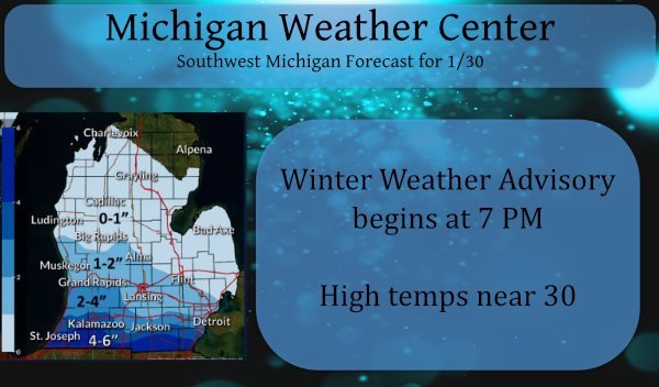
Great winter conditions and now a WWA with more snow! It just keeps coming! Let it SNOW!
Lol!!! WWA for an inch of snow! Too funny!!
More dry air, storm staying south… sounds like a whopping inch or two.
Yup, were running almost 4 feet below normal for season snowfall. Can you say dry winter.. Days keep getting longer also. I love short winters !!
The NWS shortened the WWA timeframe. It is now only until noon tomorrow. They are now only calling for 1.5” of snow here. It may not even be worth shoveling.
Let it snow let it snow let it snow!! INDY
Just another of many great winter days for outdoor sports! It has been awesome and more to come! I am heading to slopes today! Incredible winter weather! I love it!
Sounds awful! I’m staying home and staying safe. Following the guidelines. If only you could stay home, the numbers would come down and we could fully open up the state.
1-3” of snow is now a WWA? This is getting pretty comical. How many advisories has GR seen for our whole 13” of snow this winter?
The NWS issues these WWAs for hazardous driving events – many tend to forget how to drive in slippery conditions
They should bring back the old “Travelers Advisory.”
I tend to agree with you, Mark. When they post a winter weather advisory, it doesn’t really tell commuters that the road conditions are going to be potentially dangerous to travel on… The travelers advisory is a term(in my mind) that better conveys this message.
Exactly! Technically everyday in the winter with precipitation could cause trouble on the roads. I don’t think many people are taking their driving cues from the NWS.
The issue is that a lot of people do not follow the weather closely or understand advisory/warning conditions. The WWA could cover anything from 1-3 inches of snow, to 6-8 inches of snow, to less than .25 inch of ice, to lake effect snow, etc. I think they should bring back more specific advisories, like Ice Advisory, Snow Advisory, and Lake Effect Snow Advisory. Also an advisory and warning are the only two status’ we have. Maybe add level 1, 2, 3 to the warnings to we distinguish from a slightly poor driving day, to a bad driving day, to… Read more »
Winter weather advisory (WSW) – Hazardous winter weather conditions are occurring, imminent, or likely. Conditions will cause a significant inconvenience and if caution is not exercised, may result in a potential threat to life and/or property. The generic term, Winter Weather Advisory (which replaced the previously used “Travelers Advisory”), is used for a combination of two or more of the following events; snow, freezing rain or freezing drizzle, sleet, and blowing snow. The forecast accumulation criteria—defined below locally designated warning criteria or based on NWS impact-driven advisory criteria—for at least one of the frozen precipitation elements within a defined 12… Read more »
22 degrees this morning with clouds moving in. Houghton is reporting -1 and Gaylord -2.
Hard to believe February is already upon us.
I think this is the 2nd WWA issued for 1-3”. Either the public has become wimps or that we are so far below normal for snowfall that the NWS wants to alert us each time we get more than a dusting.
Fun fact: it has been nearly two years since Washington DC has had a snowfall greater than one inch.
Agreed! I feel like they are trying to stay relevant in a snow less winter.
Here is some February information! All signs point towards a cold and snowy February. The Cpc, the teleconnectors and the models! Get ready for wild ride as we head for a back loaded winter! Rock n roll will never die!
https://www.instantweathermaps.com/GFS-php/conussfc.php?run=2021013006&time=PER&var=ASNOWI&hour=240
What a joke! You said the same thing for December and January!