Congrats to Ellen Bacca who is named as the first female chief meteorologist for West Michigan. Bill is going into semi-retirement and has been named Chief Meteorologist Emeritus for WOODV. There is some question as to why Matt Kirkwood or Terri DeBoer didn’t move into the ‘chief’ role – I am thinking it is a matter of extended weather education and the others comfortable in the roles they are in now. I am sure this was discussed amongst the team and management before a decision was made. Bill and Ellen are a lot alike in many ways, both are active in their churches and communities and both are weather geeks. You can see the whole article here. https://www.woodtv.com/about-us/ellen-bacca-named-first-female-chief-meteorologist-in-west-michigan/
There is a storm complex in northern Wisconsin this morning that is moving into northern Michigan below is the 4 am update from the Gaylord NWS office:
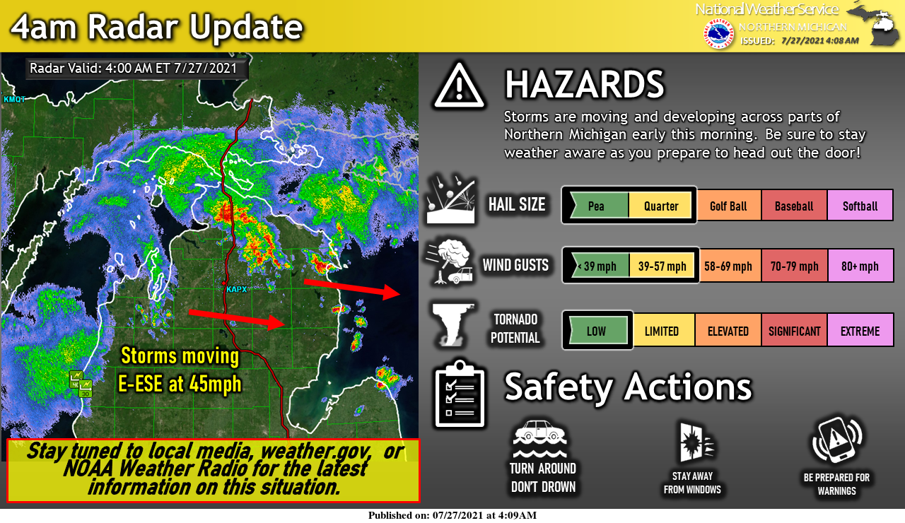
Storms have developed ahead of the earlier line of storms. Be prepared for thunder, gusty winds and perhaps small hail with any of these storms. Stay weather aware as you prepare to head out the door this morning! There will be multiple chances for thunderstorms through early this week. Isolated severe storms are possible again this afternoon, with another round of storms possible Wednesday afternoon into Thursday morning.
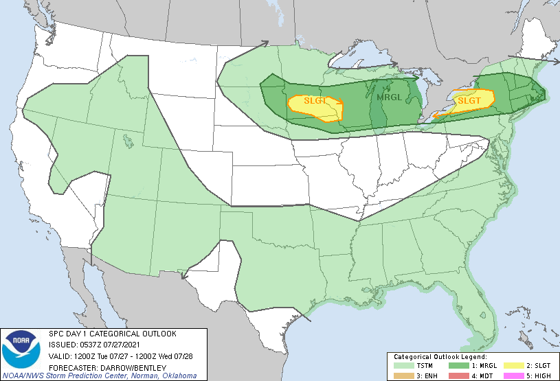
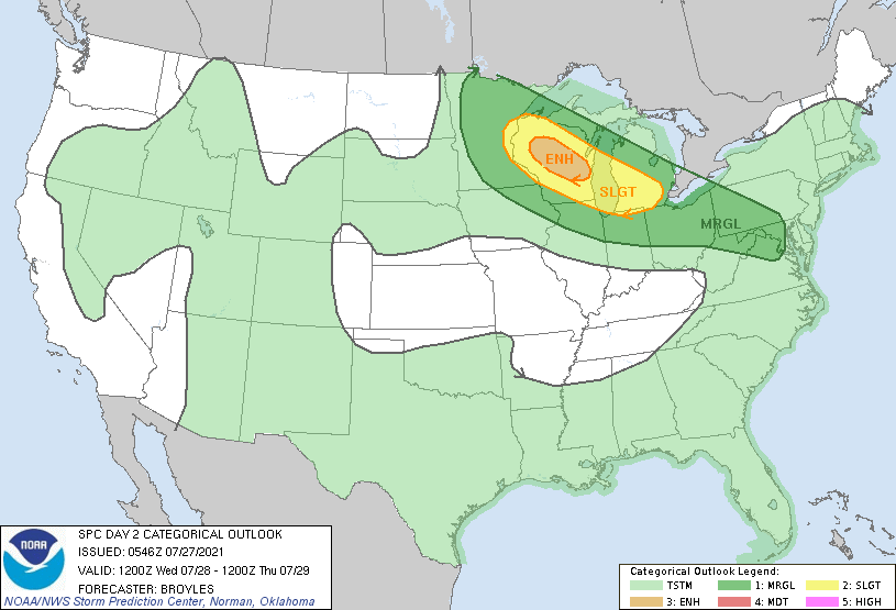
This may affect West Michigan late tonight into Tuesday though chances are in the 20 percentile range from Grand Rapids to the south. I am thinking they could be higher chances due to the SPC outlooks we shall see how this plays out. Our best chance of rain and storms will come tomorrow night into Thursday.
[columns] [span6]
Day One
[/span6][span6]
Day Two
[/span6][/columns]
Forecast Discussion:
- Some thunderstorms into mid morning today

The short story is I expect the thunderstorms crossing Lake
Michigan now to dissipate to rain showers before sunrise. The
trailing area of storms will also try to make a run at the I-96
area during the mid to late morning but it too will weaken to rain
showers and dissipate.

As for the details... There area two area of thunderstorms
heading this way early this morning. The lead area of convection
is currently crossing Lake Michigan. There seems to be an MCV over
NE WI with this area of storms. The second area that I believe
will be more significant to us is the convection that was near
Duluth and is moving south south east currently. That is where the
cloud tops are cooling the most and were the RAP model shows the
stronger upper wave. Looking at the surface, the area of storms,
now south of Duluth is in an area of good surface convergence. The
RAP model 1000/850 moisture transport shows that second area has
stronger support longer. So I believe that area will become the
area that will try to make it into the I-96 area by mid morning.
The area now moving over the lake should dissipate as it runs into
more stable air and less support. Even the area that trails it
will run out of support by mid morning since the upper wave will
be moving east of our area by then.

So, the result of all this is that the shortwave causing all this
convection will drive a cold front south today into tonight. Due
to surface heating a low may develop (shown by HRRR and RAP ) west
of Saginaw by mid afternoon. That will focus any new convection
over the thumb area. Subsidence behind the upper wave and southwest
winds off Lake Michigan all work to keep most of our CWA dry once
the remnant showers dissipate by midday.

With the front being pushed south of here tonight we will be in an
area of surface divergence and upper convergence. That will remain
so through most of the day Wednesday. So it should largely be dry
over our CWA tonight and through the daylight hours of Wednesday.

- Excessive rainfall and strong storms Wednesday night

We have collectively been writing about the system Wednesday night
into Thursday morning for more than a week now. The timing has
sped up some since we started writing about this system but it
remains a potent system for this area, even through it is coming
through the area during the middle of the night.

WPC has put this area in an slight risk for excessive rainfall.
SPC has us in a slight risk for severe storms. We have a frontal
wave that tracks southeast across southwest Michigan during the
early morning hours of Thursday. There is decent dynamics for this
wave as we have a 95 knot 300 mb jet driving this event. The NAM
has a 65 knot low level jet feeding the frontal wave. The SPC SREF
has 2000 to 2500 j/kg of MU cape into Southwest Michigan even at 2
am in the morning Thursday. The equilibrium level at 2 am over
GRR is over 45,000 ft (or over 200 mb). The precipitable water
values on the NAM rise above 2.5". The SPC SREF mean is more like
1.7 to 2.0". Model sounding show deep saturation as this wave
moves through. All of this points to heavy rainfall, localized
flooding, and at least isolated severe storms (wind damage). The
timing of this would be late evening into the early morning hours
of Thursday.

- Unsusual chilly early next week proceeded by storms Saturday

Once the frontal wave is through the area we get a large surface
high to move into the area. We will be on the anticyclonic side of
the polar jet Friday. So we should be cooler but with no
precipitation.

By Saturday a 120kt jet streak from north central Canada dives
southward to help split the polar vortex into two centers. One
over southern Hudson Bay and the other over eastern Russia. The
shortwave driving this will bring showers and thunderstorms to
the area Saturday. Then it will be unusably chilly into at least
Tuesday due to the polar jet actually being south of this area
Congrats to my personal friend Bill Steffen on going partime at wood tv 8 the guy is and always will be a legend In west Michigan I will still check in once and while on the weekends that being said I’m not a real big Ellen fan but im glad Bill tought her alot he’s that kind of guy the list is long under him Good luck friend!! As for the weather more below average temperatures on the way that’s been the trend since May around here nothing hot have a super Tuesday!! INDY
As for Ellen, she’s awesome. Congrats! Glad to see WOOD will finally embrace climate change and global warming with their meteorologists.
4 tornadoes now confirmed in Michigan over the weekend. I believe that puts us at 10 tornadoes or more for 2021 already. Way above average. Crazy!
Phew! 89 degrees again yesterday! All these 89’s this year are reminding us why the arbitrary 90 degree mark is kind of silly.
Our last 90* degree day was June 12th I believe thats week for almost Augusta in the heat dept. and there still is no sighn of any big heat coming and that saying is getting old lol…INDY
We are now up to six 89 degree days. I love it!
Bring on the late JULY cool down! It is going to be AWESOME baby!
Shhhh ..INDY
It is about time Steffens is retiring! Time for him to enjoy retirement and pass the on the reins!
Yep, the guy loves weather though. Like he was saying last night, it’s not really a job, if you absolutely love doing it everyday!
At one time the Grand Rapids metro area had in my opinion 3 of the best TV meteorologist in the country. In my lifetime the top TV meteorologist would be John McMurray, Craig James. Bill Steffens George Lessens with honorable mention going to Sonny Eliot. I have to say I do not get much of my weather information from the TV stations anymore. With that said I will say congratulations to Ellen Bacca.
Slim
That is exciting news. Congrats to both both Bill and Ellen.
We got home late last night. We spent the past week in Missouri at the Lake of the Ozarks for a family reunion. Only a little rain and thunder Sunday. Other than that, lots of sun. The water temp was 87, which felt great because the temps were in the 90s and the heat indices reached triple digits. Back to work tomorrow so laundry today and maybe a nap too.
I wonder how this affects their usual cold and snowy forecasts! LOL