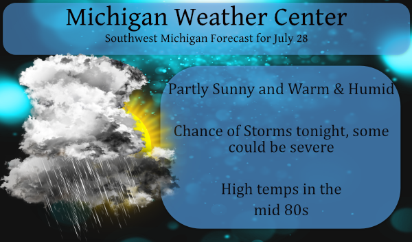
With the possibility of severe weather tonight I am holding back on weather history today.
Being downstream from moderate and enhanced storm risks makes me apprehensive when these storms can come in the overnight hours when everyone is sleeping. Below is the SPC outlook for today and tonight:
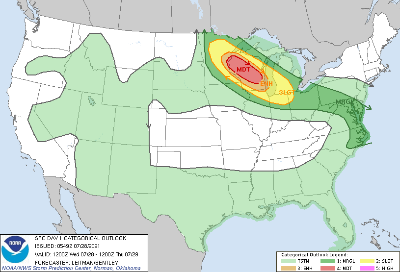
Convective Outlook
 A favorable pattern will exist over MN/WI toward Lake Michigan
   today, supporting intense severe thunderstorms and possible derecho
   development later this afternoon/evening. As a result, a Moderate
   risk has been included from extreme east-central MN into southeast
   WI with the initial Day 1 Outlook.

   An upper shortwave impulse is forecast to migrate atop the Plains
   upper ridge and amplify as it traverses the Upper Midwest/Great
   Lakes region this afternoon into tonight. In response to midlevel
   height falls, and low level cyclogenesis, 850-700 mb flow is
   forecast to increase to 45-70 kt. At the surface, a reservoir of
   substantial moisture is in place, with dewpoints from the mid 60s to
   mid 70s F. While cloudiness and some early morning elevated
   convection are possible across parts of MN/WI in a strong warm
   advection regime, steepening midlevel lapse rates and at least
   pockets of strong heating will result in strong to extreme
   instability by afternoon. A surface low is forecast to shift
   east/southeast from eastern ND into southeast MI by early Thursday
   morning, sweeping a cold front southeast across the region. The cold
   front is forecast to extend from northeast MN into northern SD late
   this afternoon, while a warm front extends southeastward from
   northeast MN into central Lower MI. Capping will limit convection
   initially, however increasing large scale ascent associated with the
   upper shortwave impulse as well as frontal forcing/low level
   convergence should overcome inhibition.

   Any initial semi-discrete convection is likely to be short-lived,
   with rather fast upscale development anticipated. Nevertheless,
   strong vertical shear and enlarged low-level hodographs within an
   extremely unstable airmass will support supercell structures (both
   initially and embedded within developing bow echo/derecho). Very
   large hail (greater than 2 inches in diameter) will be possible
   early in convective evolution. As upscale development occurs, a
   transition toward intense, damaging wind gusts is expected, with a
   corridor of 65+ kt wind gusts possible. Tornadoes also are possible
   both early on near the triple point/warm front and once an organized
   bow develops via mesovortex processes.
There is the possibility of derecho development in Wisconsin which could come across the lake into SW Michigan. There is potential for severe thunderstorms tonight that could bring damaging wind gusts, large hail and also bring the potential for localized flooding. The statement isn’t if we will have conditions favorable for storms it is when and how severe.
Forecast Discussion
- Strong to Severe storms Possible Early Thursday

It continues to look like Southwest Michigan will have a
significant threat of a cluster of thunderstorms, possibly even a
derecho moving through this area during the early morning hours of
Thursday. The setup for this is better than we typically see for
Southwest Michigan. We have tandem jet cores, one on the northern
stream and the other on the primary polar jet that come in phase
and will significantly deepen the eastern trough. As the shortwave
tops the western upper ridge and coming down the into the eastern
trough it will strengthen. That of course cause a mid and low
level response. Which comes together over northern MN and WI by
late this afternoon. The mix layer and most unstable cape in that
area will be over 3000 j/kg. The low level jet becomes unusually
strong for this time of year and will increase from around 30
knots when the storms develop over WI/MN but will increase to
around 45 knots, aimed at central Lake Michigan by around 2 am
Thursday. There is strong deep layer shear due the jet cores
coming close to this area at that time. Also the cape is deep,
model sounding show the EQ near 45,000 ft over our area during the
early morning hours of Thursday. The storms will ride the cape
gradient southeast into Southwest Lower Michigan by midnight.

The storms may be individual cells when they first develop in
MN/WI but by the time the get to Michigan they should have merged
in some sort of linear feature, meaning gusty winds will be the
most likely mode of hazard risk in our area. There is also the
threat of an area with 2 to 4 inches of rain along the track of
the MCS, which means localized flooding is also possible. These
storms will be moving quickly but with the precipitable water near
2 inches, we could see rainfall rates more than high enough to
result in areas with more then 2 inches of rain. An isolated
tornado would not be out of the question, but that depends on
where the surface wave actually tracks. Seems the risk for that
would be south and west of Grand Rapids.

So the real question is not, will there be these strong to severe
storms early Thursday morning, but where will they actually be?
As typical of our numerous models that forecast these things the
track is anywhere from NE- WI toward N IL to TVC to DTW. It seems
to me the real question is where does the surface low track? Just
about all the models have the strong storm just east of the track
of the surface low. The ECMWF is way north compared to the other
models with this feature. Most of the other models have the
surface low tracking from southern WI to near Kalamazoo. If that
is the track of the surface low, we would have the risk of
isolated tornadoes. There would be just enough low level shear
and with a low LCL and decent low level cape, that is a real
possibly.

At this point my best guess is the greatest risk of strong to
severe storms will be south and west of Grand Rapids. I do think
locally heavy rain is likely west of US-131 (more or less).

Once the storms roll through I would expect some clearing by
midday Friday. While the cold front comes through Thursday morning
the actual cold air does not get in here until Friday morning.

- Stronger cold front brings showers Saturday

As I have been writing about all this week, we are seeing a major
change to our overall weather pattern take place. This is actually
are response of the northern hemisphere wave pattern to MJO
tropical convection, which is now in phase 6. That supports cooler
than normal temperatures over nearly all of the eastern United
States. This will take several shortwaves to get done. The first
one will cause the thunderstorms early Thursday. The next one
comes through our area in Saturday. Likely we will see more
showers and maybe a thunderstorm. The GFS brings the upper level
low over Michigan Sunday (fastest run). That would mean enough
instability in the afternoon for inland showers and thunderstorms
on Sunday into Monday.

- Prolonged period of cooler weather

We have more shortwaves diving into this eastern trough, so the
cool weather and periodic showers will continue most of next
week. This is supported by all of our medium range models and
there ensembles a well as the MJO teleconnections.
PDS Severe Thunderstorm Watch for Wisconsin
https://www.spc.noaa.gov/products/watch/ww0399.html
At this time the radar to our west at this time is not all that impressive yet. There is some activity in north central Wisconsin with more so in the arrowhead of Minnesota. We will see how this plays out in the next several hours.
Slim
–Damaging winds and heavy rainfall possible late tonight– Latest CAMs seem to have locked in on the farther north/northeast track of the most severe convection later tonight, still hinting at the possibility of a significant bow echo/potential derecho impacting much or parts of wrn Lwr MI. This may be a high impact severe weather event occurring while many folks will be sleeping, so messaging the possibility of damaging/destructive winds well beforehand is critical. Timing still looks to be after 11 pm, with potential for a large bow echo sweeping across Lk MI overnight. Also some potential for the warm advection… Read more »
I am getting my plants in pots put safely out of the storms. I won’t be sleeping thru this. I remember the one in 1998 when it came around 6 AM and tree limbs fell on our house.
Moderate risk for west Michigan now!! This could be a crazy night stay tuned …INDY
Awaiting the 3:30PM update… I think at this point it is not a question of “if” a strong wind complex will develop, but “where” the strongest winds will end up (and how strong).
Potentially widespread severe thunderstorms are expected late this
afternoon through tonight along a corridor from northeastern
Minnesota across Wisconsin into southwest Lower Michigan. A few
severe storms are also expected this afternoon over parts of
Virginia and North Carolina.
We are now in the Enhanced area here is West Michigan with the moderate area up to the Lake Michigan shore on the other side of the lake.
Slim
Our cable lines just got put back up today after Saturday’s storms blew trees down on them. Hope we don’t need to call them back again tomorrow already.
Derecho. There’s a term rarely used. I’m a weather nerd, so my wife and kids razz me (with love, of course) whenever I mention the word derecho. 🙂
West Michigan is now in the ENHANCED outlook
Slim
My thoughts on tonights storms timmin is off and lake Michigan end of story light rain showers possible lol….INDY
However this month ultimately turns out, it will go down as being near average temps. That means we are still on track for a warm meteorological summer with one month to go.
However nothing hot that’s the best part of all!! Since May we have had no heat in sight woo wooo let’s keep it going through August!! INDY
It’s surprising that we’ve had no real cold shots this summer. We’ve had a greater number of double digit warm days than double digit cold days this summer.
So far this meteorological summer there have been 3 days mean temperatures of double digit below average and 4 days of double digit above average. So far this summer there have been 31 days above average 26 below average and one at average.
Slim
Actually, I count 5 double digit above per NWS. Your post also says “double digit below average” twice. I think you meant above average for one of those.
First off I changed the comment to 4 above and 3 below. All double digit departures daily mean departures from average this summer so far have happened in June. On the above side they were June 6th +12.7°, June 9th +11.8°, June 11th +11.2° and June 5th +11.8° (your 5th day June 4th ended up at +9.8° and that was rounded up to 10) and for the below days June 22nd -15.7° June 21st -11.5° and June 23rd – 10.9° and the month of June ended up at +2.0 at Grand Rapids.
Slim
Yep
It looks like starting this weekend we should see a patter change and that change looks to bring much cooler and drier conditions to much of the eastern US. So far this summer has been a kind of typical summer for our area. There have been both warm periods and cool and conformable periods. So bottom like is get out and enjoy the summer and early fall seasons as soon enough it will be back to the cloudy and cold days we have here from late October to mid March. Most of our “don’t have to” that is days we… Read more »
We will have to see how tonight’s potential thunderstorm complex plays out. At this time Grand Rapids is just about average temperature wise for the month of July. The current departure is now at -0.2. The overnight low both here at my house and at GRR was 67 at the current time it is clear here with a temperature of 68 and a DP of 63.
Slim