Throughout the history of the world, we have variations of our climate from warm to cold and wet to dry. We can blame some of the variations due to human impacts especially when coal was the main fuel for industry. Some can be blamed on our own planet when volcanoes erupt spewing ash into the atmosphere. It has always been my opinion we have to look at the big picture when looking at the great ocean of our changing atmosphere.
Putting all of this aside, climate does vary without human influence, and this natural variation is a backdrop for the human-caused climate change occurring now. These patterns hold important lessons for understanding the magnitude and scope of current and future climate changes.
Cyclical variations in the Earth’s climate occur at multiple time scales, from years to decades, centuries, and millennia. Cycles at each scale are caused by a variety of physical mechanisms. Climate over any given period is an expression of all of these nested mechanisms and cycles operating together.
Millennial Climate Cycles
Major glacial (cold) and interglacial (warm) periods are initiated by changes in the Earth’s orbit around the Sun, called Milankovitch cycles. These cycles have occurred at different intensities on multi-millennial time scales (10,000 – 100,000 year periods). The orbital changes occur slowly over time, influencing where solar radiation is received on the Earth’s surface during different seasons (NASA 2000).
By themselves, these changes in the distribution of solar radiation are not strong enough to cause large temperature changes. However they can initiate powerful feedback mechanisms that amplify the slight warming or cooling effect caused by the Milankovitch cycle. One of these feedbacks is caused through changes in global surface reflectivity (also called albedo). Even a slight increase in solar radiation at northern latitudes can increase ice melt. As a result of ice loss, less sunlight is reflected from the bright white surface of the ice, and more is absorbed by the Earth, increasing overall warming. A second feedback mechanism involves atmospheric greenhouse gas concentrations, such as carbon dioxide. The slight warming initiated by changes to Earth’s orbit warms oceans, which allows them to release carbon dioxide. As we’ve seen, more carbon dioxide in the atmosphere causes more warming, creating an amplifying effect (Hansen 2003). Distinct feedbacks in atmospheric CO2 concentrations may lag warming or cooling caused by orbital changes by as much as 1000 years.
In this way, what begins as fairly minor changes in orbit can produce the glacial and interglacial cycles of the last 800,000 years. A major concern with current climate change is that similar feedback mechanisms will cause a ‘runaway’ warming effect in modern times that will be extremely difficult to halt or reverse.
Century-scale Climate Cycles
In addition to multi-millennial glacial and interglacial cycles, there are shorter cold-warm cycles that occur on approximately 200 to 1,500 year time scales. The mechanisms that cause these cycles are not completely understood, but are thought to be driven by changes in the sun, along with several corresponding changes such as ocean circulation patterns (Bond et al. 2001, Wanner et al. 2008). The Medieval Warm Period (900-1300 AD) and the Little Ice Age (1450 to 1900 AD) are examples of warm and cold phases in one of these cycles. Some of these cycles, such as the Medieval Warm Period, may be regional, not necessarily reflecting large changes in global averages. Understanding and reconstructing the regional patterns of climate change during each of these periods is considered very important in accurately analyzing future regional impacts such as drought patterns (Mann et al. 2009).
Interannual to Decadal Climate Cycles
Ocean-atmosphere interactions regularly cause climate cycles on the order of years to decades. One of the most well-known cycles is the El Niño-Southern Oscillation (ENSO), an interaction between ocean temperatures and atmospheric patterns (commonly known as El Niño or its opposite effect, La Niña). ENSO events occur every 3 to 7 years, and bring different weather conditions to different parts of the world (NASA 2009). For example, in the U.S., El Niño events can result in a flow of warm dry air into the Northwest, but above average rainfall in the southeast (NASA 2009).
Many other cyclical changes due to oceanic and/or atmospheric processes have been described, such as the Pacific Decadal Oscillation (PDO) which occurs in cycles of 25-45 years (Mantua et al. 1997), and the Atlantic Multi-decadal Oscillation (AMO), occurring on approximately 65-85 year cycles (Deser et al. 2010). Scientists are studying how each of these reoccurring cycles might interact with the enhanced greenhouse effect. There is some evidence that global warming may be intensifying ENSO events
Now we look at our chances of snow for Tuesday night. There are still a lot of variables in the track of the storm system so I am not going out on the limb to say it will be a snowmageddon event, however, as of now, the NWS is predicting five or more inches south of I96. This would be the heavy wet variety that could cause tree damage.
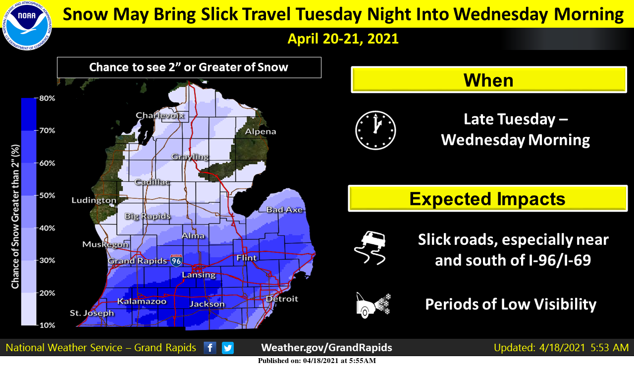 Late-season accumulating snow is looking more likely to occur across parts of Lower Michigan late Tuesday into early Wednesday morning. The main impact will be to travel, both Tuesday night and for the Wednesday morning commute. The forecast track of the low-pressure system responsible for bringing the snow could still shift however, and adjustments to the forecast are possible. Precipitation is expected to begin as a rain/snow mix Tuesday afternoon, then change to all snow Tuesday evening as temperatures fall.
Forecast Discussion
- Fairly quiet and mild today

Upper trough axis dropping through Lower Michigan will bring mid and
high clouds to the area today. Overall, areas north of I-96 stand to
see the most sun. After a chilly start to the morning, we should see
highs reach near 60 degrees in most locations, which is within a few
degrees of normal.


- Cold front brings chance for showers late tonight and Monday

While temperatures tonight are expected to drop into the mid and
upper 30s, the frost threat will be mitigated by southerly winds and
increasing clouds associated with low pressure as it begins to trek
through Northern Michigan. The cold front associated with this
system will sweep down through the area late Sunday night through
Monday afternoon, bringing showers to the area. Best coverage looks
to be west and north of Grand Rapids, closer to mid-level energy and
where the left-exit region of a weak jetlet will give low/mid-level
lift a boost. Latest forecast soundings support rain as the
precipitation type, but would not be surprised to see some wet
snowflakes mix in near Ludington and other locations near/north of M-
10 Monday morning. High temperatures will be dictated by how early
the cold front comes through, with reading expected to range between
the mid 40s in West Central Lower to the upper 50s towards I-94.
18.00Z models are showing great agreement with the surface front
settling into the Ohio Valley Monday night, but light rain/snow
showers may linger over Southern Michigan.


- Potential for accumulating snow Tuesday night

Models continue to show a large area of upper energy dropping from
the Canadian Territories into the longwave trough currently over the
CONUS starting tonight. Some of this energy will settle into the
Plains, where an upper trough will sharpen before progressing into
the Great Lakes. This will send an area of deepening low pressure up
through the Ohio Valley Tuesday night, spreading late-season snow
across the region on the northwest side of the low track. As usual,
the challenging part is figuring out where exactly the low center
will track and where the heaviest swath of precipitation will be
placed. While slightly different from each other on low track and
placement of precipitation, recent Euro and GFS model runs had shown
good consistency with their previous runs up until now. The 18.00Z
operational run of the Euro took a jog towards the GFS, boosting
confidence a little in its more southerly track. We still cannot
rule out a shift to the left (north) however, as is sometimes the
tendency with these systems as we get closer. Latest forecast does
favor the heaviest amounts of precipitation near and south of the I-
96/I-69 corridors. This is supported pretty well in the latest GFS
ensembles.

This system has a lot going for it, as increasingly favorable right
entrance region forcing helps boost the FGEN response in the low/mid
levels and it taps into pool of deeper moisture to the south. Max
QPF amounts withing the deformation zone are mostly within the 0.6-
1.0 inch range, which is impressive given the cold airmass.
Precipitation looks to arrive mostly in the evening and overnight
(slightly later than 24 hours ago), and forecast soundings strongly
support snow as the dominant precipitation type across our entire
area. In the area where the stronger lift from this system will
be placed, forecast soundings show a deep DGZ and think snowfall
rates at times will be able to overcome the warmer ground. We
expect to see travel impacts Tuesday night within the heavier
swath of snow, which will then linger into the Wednesday morning
commute. As mentioned, there is still some uncertainty to where we
could see several inches of snow, but the best potential at this
point is near/south of the I-96/I-69 corridor.


- Temperatures below freezing Monday night through Thursday night

Colder air will settle into the region Monday and remain in place
through much of the week. Temperatures look to fall below freezing
for at least three nights in a row (Monday night through Thursday
night) and could damage or kill sensitive vegetation. High
temperatures are expected to rebound into the 40s Tuesday and
Wednesday, and the 50s Thursday.
Incredible cold is coming!
We went for a long walk around downtown Holland today since its so nice out. The tulips are about all in full bloom already with all the Summer like weather we’ve had, in fact many of the early ones are already done. Between all the flowers and blooming dogwoods it looks just incredible around the town! Ton of people out walking around, and pretty sure none of them were focusing on the wet slop if any that we may or may not get in a couple days. Get out and enjoy this incredible weather!
The trend for the snow is now more south and lighter. So it looks like the big issue for the week with be for a hard freeze. At this time it is nice and sunny and a pleasant 61 here at my house. I think this will be a good time to go out and cut the grass.
Slim
Wow wouldn’t that be something getting more snow at the end of April then last March …WHO KNEW???
Cold, hard freezes, and accumulating snow. Just another rosey outlook for the Southern Arctic.
YES YES YES February weather at the end of April !! GREAT SCOTTY!!! INDY
Just another beautiful day! Already 50 degrees, sunny again, and no breeze. Not sure how this feels like February?
Good morning MV’s best furnace running this morning heat on my truck is it April or February I’m forgetting lol…ohhh and I had low of 30* degrees in my area shuuuu ….INDY
Nice write up on climate cycles. The overnight low here was 29 and with clear skies there was some frost. At this time it is clear and 30. With some snow in the forecast it would not take much snow fall to set a new record for Tuesday as the record for April 20th at Grand Rapids is just 0.4″ set in 1943. At Muskegon it is 0.3″ set in 1953 at Kalamazoo it is just a trace and at Lansing it is 2.0″ set in 1947. For Wednesday the record at Grand Rapids is 2.0″ set in 1924 at… Read more »
Our local TV met said we may get 2-5” but it’s too early to see where the heaviest band will set up. Oh well, it won’t last.
Looks to be another beautiful day on tap today. Lots of golfers on our course this morning.
As a side note, when I was growing up in the 50s and 60s the paper mills in the Otsego/Plainwell, Kalamazoo areas spewed out all sorts of pollution – some days it was unbearable when there was no wind to circulate the air. Things are a lot better now compared to back then…
I did my AIT at Fort Gordon in early ‘92, downriver from a Georgia Pacific paper mill. When the wind would blow from the NW, it was so pungent, almost nauseating.