
The question was asked about the recipe for my chicken noodle soup. I don’t use recipes per se, the ingredients are in my mind after years of preparation of both chicken noodle soup and of course, chile made in large batches. I also make liver and onions with fried potatoes, the liver almost melts in your mouth and is delicious. I make the soup the Amish way using the biggest chicken I can find throw it into the largest pot I have and boil it down until the meat falls off the bones. The meat then needs to be deboned while vegetables are cut and put into the pot (carrots and celery are good). The deboned chicken is then put back into the pot with whatever spices I decide to add as long as it includes lots of garlic. I then add small ribbon noodles to the mix for the last eight minutes or so. My batches feed about ten people some of whom have more than one helping, there generally aren’t any leftovers.
Yesterday we received 2.61 inches of rain with the high temperature briefly reaching 70° (in Otsego).
Our cloudy and wet weather will continue today. Gusty winds will accompany a cold front that will continue to drop temperatures. Gusts upwards of 25 mph are possible. The damp and dreary conditions continue into next week with cooling temperatures and rain chances each day.
SW Michigan Forecast
U.S.A and Global Events for October 6th:
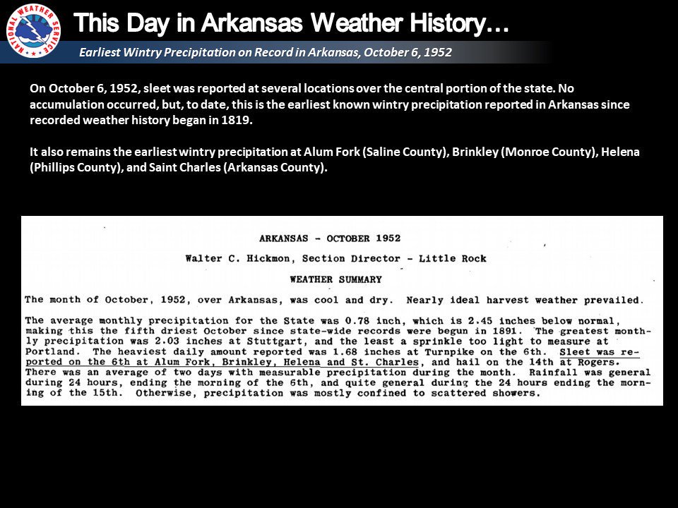
1952: Sleet fell at several locations, making it the earliest documented winter precipitation in Arkansas.
1981: The Netherlands’ fourth-worst aircraft accident (at the time) occurred on this day. At 5:09 PM, the crew noted heavy rainfall in thunderstorms on the weather avoidance radar and received clearance to avoid this area. At 5:12 p.m., the aircraft entered a tornado, which caused the right wing to separate from the plane. All 17 occupants of the plane perished in the accident. The Accident description can be found HERE.
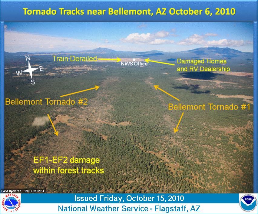
 2010: A significant severe weather event struck northern Arizona with at least eight confirmed tornadoes. This event will go down in history as the most tornadoes to hit Arizona in a single day. An EF2 tornado was on the ground for 34 miles, ranking as the longest-tracked tornado in Arizona history.
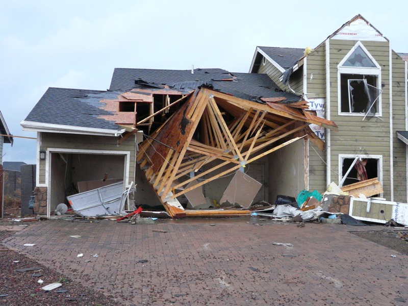 A home damaged by an EF2 tornado in Bellemont, Arizona. Image courtesy of the National Weather Service office in Flagstaff, Arizona.
2016: Around a half dozen tornadoes struck Kansas, including an EF-2 and EF-3 in Saline County.
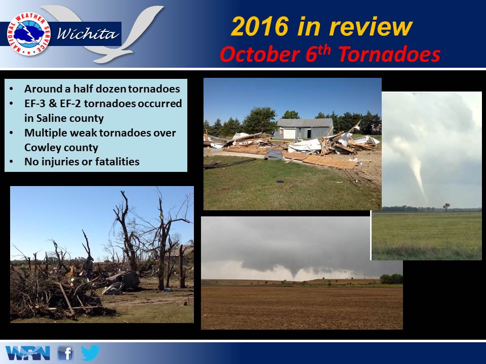
The image above is from a tweet by the NWS Office in Wichita, Kansas.
2016: The center of Category 4 Hurricane Matthew passed within 100 miles of Miami, Florida.
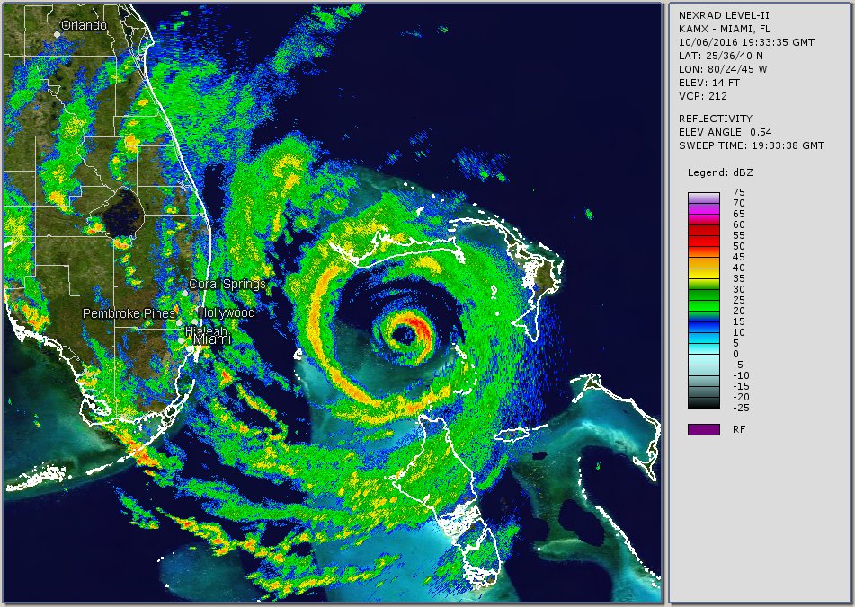
The image above is from Brian McNoldy, a Senior Research Associate at the University of Miami’s Rosential School.
Forecast Discussion
Surface observations currently show a well-defined cold front in
place across lower Michigan this morning, with this front expected
to move eastward over the coming hours. A relative lull in
precipitation along with clearing is expected for the morning
hours before another cold front is driven across the area by a
robust shortwave during the afternoon and evening hours. This will
bring an uptick in shower coverage across the area Friday
afternoon. Highs will be around 60.

This second cold frontal passage ushers in a significantly cooler
air mass with 850 mb temperatures falling below 0C. With Lake
Michigan surface temperatures still in the mid to upper sixties,
delta T/s increase to near 20C. This promotes significant lake
induced CAPE values of 1000-2000 J/kg along with equilibrium level
heights rising to near 20k feet. As a result Friday night and
Saturday will feature widespread lake effect clouds and ample
coverage of lake effect showers. Given the significant values of
lake effect instability, a few thunderstorms are possible, along
with small hail given freezing level heights falling to under 5000
ft. The best chance for this is west of US131. The widespread clouds
and showers will hold high temperatures into the 50s. Highest QPF
values look to be in our southwest CWA (Southern Ottawa/Allegan/Van
Buren/ Western Kalamazoo Counties) where the northwest flow pattern
supports the most persistent lake effect showers and storms with the
potential for over localized totals over one inch. Otherwise, expect
0.25-0.75 inches west of US131 and up to 0.25 inches east.

Not much has changed for the extended forecast. The upper level low
that moves through Saturday will continue to influence our weather
over the next week. Northwest flow over the warm waters of Lake
Michigan will continue shower chances (30 to 50 percent) for the
western half of the area Sunday. Speaking of these warm lake
temperatures chances for waterspouts (20 percent) continue through
Sunday. The convective cloud depth and 850mb and water surface
temperature difference will be conducive for waterspouts with any
shower. Monday precipitation chances are not as high (20 to 30
percent) as there isn`t as much support from positive vorticity
advection as the previous day. With the upper level low placement and
northwest flow continuing through the week kept NBM PoPs. Ensembles
also show precipitation off an on all week, but amounts are light.
No one day will be a washout. There is a bit less certainty for the
later half of next week with how the upper level low over
Ontario/Quebec evolves. Just know that the dreary fall weather
continues.

Temperatures over the extended forecast will remain rather
consistent in this pattern. Overall highs in the 50s with lows in
the mid 30s to 40s. We`ll have to watch the potential for frost, but
winds might be elevated enough to limit any development.
Michael, Thanks for the chicken soup recipe. Your potato and onions and liver is like the one I use. We always make lots of chili too when we make it. I love having it on hand in the freezer. Thanks again. Sandy
Here comes more rain! Incredible!
The latest CPC outlooks look great, if you like below normal temps! What a pattern! Wow!
Record setting (Battle Creek and Lansing) rainfall yesterday. Rainfall amounts in this area were anywhere from 1.75″ to 3.41″. Reports near my house were a little over 2″.
The weather system that moved through over the last 24 hours brought considerable rainfall to southern lower Michigan. There was a swath of rainfall that eclipsed 2 to 3 and a half inches. Several station records were broken both at Lansing(LAN) and Battle Creek(BTL) airports. These were 1.75R and 2.80R respectively. Parts of this region were still in a D0 drought so this will help improve any remaining drought conditions.
Storms are expected 4 to 9 PM. Isolated severe storms are possible with damaging winds, and locally heavy rainfall as the main threats. Localized flooding is possible, especially due to yesterday’s heavy rainfall. Kalamazoo, Battle Creek and Lansing areas are a concern.
Good riddance 80’s and hello 30’s! Who wouldn’t want cool weather this time of year?
Michael,
I make my stock like that. We get a roaster chicken and I make my stock with the bones and skins. I freeze it most of the time to use it for all sorts.of recipes. I used it on my chicken and noodles last night.
Marginal Risk of severe weather in place today for areas near and west of 131
… “it appears possible that a few
strong/severe wind gusts could occur with showers/thunderstorms
along the coast of southwest Lower MI. Therefore have added a small
MRGL risk area for this scenario. Cold temperatures aloft and
ambient vorticity near the upper trough could also result in
isolated waterspouts in this area.”
Plenty of rain at my house yesterday. We never really had a deficit at my house we have had plentiful rains here so this was just extra rain. The mosquitos are still super thick in this area.
I have not seen a mosquito is weeks!
You’re lucky!
Perfect hunting weather. And we had a good line of storms come through last night. We needed the rain.
We are now at October 6th and the coldest it has gotten this fall season in 44 back on September 19th At the current time it I partly cloudy and 48 here in MBY. The average first 32 day at Grand Rapids is October 14th The earliest is September 3rd 1946 and the latest is November 14th 1918. Last year it was October 8th
Slim
Get ready for night lows well down into the 30’s! Wow!
The official high yesterday was 73 just after midnight the low was 60. There was 1.12” of rain, here in MBY I recorded 0.89” of rain. The highest wind speed was 33mph out of the w. There was no sunshine. For today the average H/L is 65/45. The record high of 87 was set in 2007 and the record low of 28 was set in 1964 and 2003. The record rain fall of 1.58” fell in 2016. Last year the H/L was 71/44 with a trace of rain fall.
Slim
Incredible cold is coming!