
Yesterday we reached 81° which is possibly the last time we will see that for the rest of the year. Showers and isolated storms will continue through the day today before gradually ending from northwest to southeast later this afternoon through this evening. Damp and dreary conditions will continue into next week with temperatures falling into the 50s and rain chances each day. The leaves of our walnut trees have been falling along with the walnuts which can be dangerous if you are working under them. I have had a few close calls this week.
SW Michigan Forecast
U.S.A and Global Events for October 5th:
1786: The famous “Pumpkin Flood” occurred on the Delaware and Susquehanna Rivers. Harrisburg, PA, reported a river stage of twenty-two feet. Click HERE for a youtube video.
1864: A tropical cyclone hit India near Calcutta, devastating the city and killing about 60,000 people. Click HERE to read the Report on the Calcutta Cyclone of 5th October 1864.

“Effects of the cyclone at Calcutta,” from the Illustrated London News, 1864.
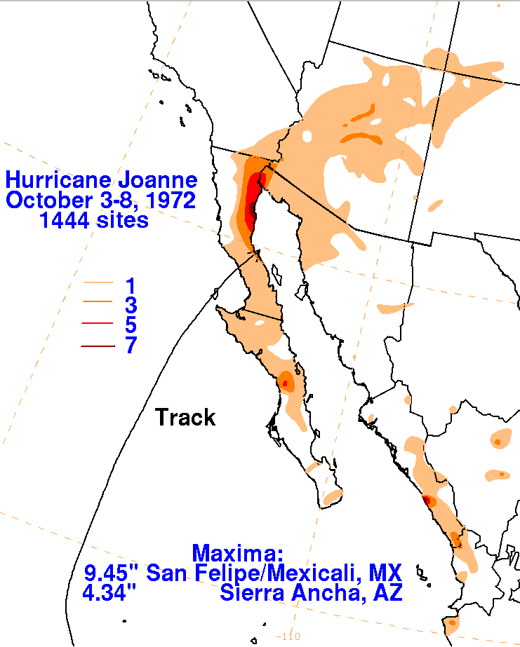
1972: Tropical Storm Joanne, earlier a hurricane, moved across the Baja California peninsula and came ashore in western Mexico south of Ajo. The storm brought heavy rain and flooding to much of Arizona. This storm is the first documented tropical storm to reach Arizona, with its cyclonic circulation intact. Over 5 inches of rain was reported on the Mogollon rim southeast of Flagstaff. Additional rainfall amounts included 4.44 at Flagstaff, 3.80 at Prescott, 2.21 at Yuma, 1.95 at Phoenix, 1.63 at Nogales, and 1.63 at Tucson.

The image above is from the ESSA 9 weather satellite of Hurricane Joanne taken on October 2, 1972, at 2233 UTC.
Click HERE for more information from the Weather Prediction Center.
2010: Large hail pounded Phoenix, Arizona, causing nearly $3 billion in damage. Click HERE for more information from the NWS Office in Phoenix, Arizona. Click HERE for a YouTube video.
Forecast Discussion
Regional mid-level water vapor imagery has shown an increase in
Mid-level moisture moving into Lower Michigan, with RAP MUCAPE
values of 500-1000 J/kg (also some surface-based instability
present) moving over the lake and gradually advecting inland into
the early to mid-morning hours. A few thunderstorm clusters have
developed along a slow-moving line of showers associated with a
surface front pushing through the region. With upper jet
divergence and also 500 mb PVA, there is good synoptic support
coupled with dynamic support to keep the thunderstorm risk alive
this morning and into the afternoon.
The 00z CAMs are in good agreement about a fairly widespread
0.50″-1.00″ of rain across the region, mainly along and east of a
line from South Haven to Holland to Big Rapids. 00z HREF 24 hr
Probability-matched mean precipitation amounts indicate localized
rainfall of 1″-2″ possible today. Given most areas have rainfall
deficits going back to early September, this rain should get
readily absorbed but there could be some ponding of water on roads
in the heavier showers and thunderstorms.
A break in the precipitation is expected Thursday night and into
Friday morning before deep upper troughing moves in and 850 mb
temps crash over Lake Michigan. Lake-induced SB CAPE values of
1000-2000 J/kg are expected as this occurs, with numerous lake-generated showers and some thunderstorms occurring as early as
Friday afternoon. Breezy conditions may develop with 20-30 mph
gusts. It will start to feel like October out there.
As the upper-level trough moves through Friday night into Saturday,
northwest winds and colder air filter into the region. This will
bring a nice setup for lake effect showers and even a few
thunderstorms closer to the lake through the weekend. Warm lake
temperatures around 18-20C and cooler temperatures aloft will be
an ample source of instability with around 1500-2000 J/kg over the
lake. Along with the showers and storms northwest winds will ramp up
with gusts around 20 to 30 mph. Winds won`t be as strong Sunday but
these showers will continue and potentially linger along the lake
into Monday.
Temperatures during this time will mainly be in the 50s and paired
with the expected weather this weekend, it`s not going to be nice
outside. There is lower confidence with the overnight low
temperatures as it will be dependent on cloud cover. If the clouds
clear we could see those lower temperatures that the NBM has,
otherwise if the clouds remain lows may be mainly in the 40s.
As we head into next week precipitation chances could linger. This
is due to the upper-level low that moves through Friday night
remaining over the eastern Great Lakes region. We have truly
entered fall with this closed low system. Clouds, rain, and cooler
temperatures.
We have been in the sweet spot for rain today, over 2.5 inches thus far between Otsego & Plainwell, here is my RadarScope digital accumulation array image at 1:30pm

At least it isn’t blowing sideways, have been able to sit on the front porch. Lol
Good point. There has been zero breeze until recently.
It is starting to clear here now. The total rain fall here in MBY for this event is now at 0.89″ the current temperature with clear skies in 63.
Slim
We’ve been getting a gentle, soaking rain all morning. Water is starting to pool out back on the golf course. We made a pot of chili yesterday. Of course, we haven’t dug into it yet. Never eat chili the same day it’s made. I’m fixin to pull it out of the frig and put it on the stove.
I made chicken and noodles in the crockpot!!!
This is one of my favorites to make 🙂
What time is dinner?
Any chance you have a recipe to share?
Always the best the second and third day, gives the chili a chance for the flavor to permeate everything in the pot.
Truth
I agree.
Slim
The official H/L at Grand Rapids yesterday was 82/60. That is the 1st time in recorded history that Grand Rapids had 4 days in a row of 80 or better to start the month of October. A new record high of 84 was set at Muskegon. For today the average H/L is 66/46 the record high of 85 was set in 1900, 1922 and 1946 while the record low of 29 was set in 1965 and 2004. The record rain fall amount of 1.72” fell in 2013. So far today here in MBY I have recorded 0.86” of rain fall… Read more »
I am glad to see the rain!! Up to .6 inches already! Bring it!
Get ready for at least 4 nights in a row of temps of near 40 degrees or lower! Wow, just wow, WOW! Good riddance to the 80’s! I love it!
I was browsing some old photos on my phone and noticed a couple trends with 2016-2017 and 2018-2019 winters (both had El Ninos). The 2017 winter had several very warm periods, including in February where there was a week of 60s and significant flooding from melting snow. Also 2019 started off very snowless, with basically no snow up until mid-January. I even have pictures of January 14 with sunshine and grass. 2019 technically did have the “bomb cyclone” and a quick visit from the PV later in the season, but overall both seasons were warm and dry. Maybe this season… Read more »
That’s over 2 weeks straight of above average temps!! Who wouldn’t love warm weather this time of year?!?!! WOW!!!
Just another above average temp day!! Incredible!!
I’m personally enjoying this new weather pattern. Much more festive for Halloween and October. I’m sure ill get sick of it by November… but in the meantime it’s pretty relaxing and fits the atmosphere
Get ready for some incredible cold! Wow!!!