We have 4° with a windchill of -19° in Otsego at 5:45 this morning. The heaviest lake effect is around the Grand Rapids and Belding areas.
Temperatures will remain in the low teens for daytime highs and the nighttime lows in the single digits the rest of the week with off-and-on lake-effect snow showers for the lakeshore counties.
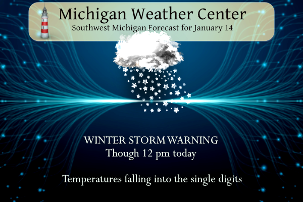
...WINTER STORM WARNING REMAINS IN EFFECT UNTIL NOON EST TODAY...

* WHAT...Heavy snow. Additional snow accumulations of 2 to 6
  inches. Winds gusting as high as 35 mph.

* WHERE...Muskegon, Ottawa, Kent, Ionia and Allegan counties.

* WHEN...Until noon EST today.

* IMPACTS...Plan on slippery road conditions. Areas of blowing
  snow could significantly reduce visibility.

* ADDITIONAL DETAILS...Snowfall rates will likely top two inches
  per hour within any stronger bands Wind chill temperatures will
  fall to zero to 10 below tonight.
Forecast
Weather History
1893: A long siege of arctic cold drops the temperature below zero for 15 out of the first 19 days of January at Lansing. This is the coldest day of the month with a low of 16 below zero.
1932: Grand Rapids is in the midst of a stretch of six days with temperatures above freezing during the warmest January on record.
2005: Two days of heavy rain and high temperatures in the 50s are followed by a stretch of arctic cold, causing massive ice jams to form on the Grand River. The ice jams resulted in devastating flooding of Robinson Township in Ottawa County. Flooding also occurs on stretches of the Muskegon, Thornapple, Flat, and Kalamazoo rivers.
2015: Arctic air and clear skies allow temperatures to drop well below zero. Grand Rapids sets a record low for the second consecutive day with a low of 13 degrees below zero.
On January 14, 2009, the region was in the middle of a five-day arctic outbreak. Flint set a record reaching -19 degrees. Detroit was a low as -3, while Saginaw was -10.
Also on January 14, 2004, a “super-clipper” brought heavy amounts of snow across portions of Southeast Lower Michigan. Heaviest amounts included, Port Huron 12.0″, Grand Blanc 11.0″ and 10.9″ at the NWS White Lake. Other areas across the northern/western suburbs of Detroit saw between 7.0″-10.0″, while Detroit Metro Airport received just 4.7″.
U.S.A and Global Events for January 14th:
1882: Snow fell in southern California, with the highest amount of 15 inches at San Bernardino. Three feet of snow fell in Campo over four days and produced 8-foot drifts in spots. Two to five inches fell in outlying San Diego, including four inches along Poway Grade, 3 inches at El Cajon, and one inch in Poway. Five inches fell in Riverside. Light snow fell in Del Mar. Snowflakes fell but did not stick at San Diego Lindbergh Field. Birds and livestock were killed, telegraph lines were knocked down, and citrus crops were damaged.
1972: In Loma, Montana, the temperature soared from 54 degrees below zero to 49 degrees above zero on January 14-15, 1972. The 103-degree change is the greatest ever recorded in the world for a 24 hour period. Click HERE for more information from Popular Science.
2009: In Washington State, freezing fog and freezing drizzle enveloped much of the Inland Northwest during 13-23 January 2009. The area most affected by this was the high plateau region along Highway 2 between Wenatchee and Spokane. Click HERE for more information from the NWS Office in Spokane, Washington.
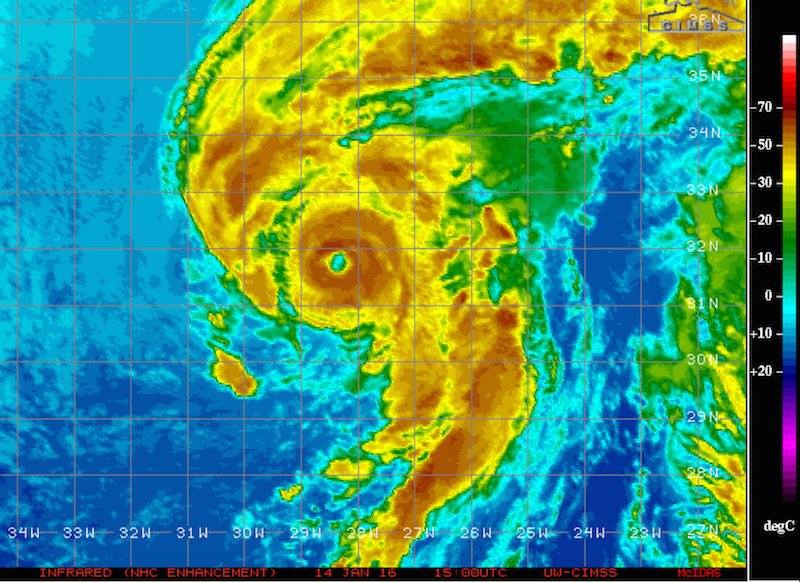
2016: Hurricane Alex became the first January hurricane in the Atlantic since Hurricane Alice in 1955.
Forecast Discussion
- Heavy Lake Effect Snow and Blowing Snow This Morning

Overall the forecast remains on track. Lake effect snow is
currently focused in Muskegon Ottawa, Allegan, Kent, and Montcalm
counties which is oriented with the 925mb frontogenesis and
converging streamlines seen on SPC mesoscale analysis. 2 inch per
hour snowfall rates have been observed within the strongest
reflectivities on radar. The area of convergence is expected to
focus more along a Grand Haven to Grand Rapids to Ionia line this
morning before tapering off this afternoon as we loose the deep
moisture and the dendritic growth zone drops closer to the
surface. With the ongoing snow, blowing and drifting snow
associated with the gusty winds of 30 to 40 knots (mainly along
and south of I-96), low visibilities, and snow covered roads will
continue with the Winter Storm Warning and Winter Weather
Advisory. Additional accumulations within the warning range from a
couple inches to 6 or more where the heavy snow band remains the
longest over. Within the advisory an additional 1 to 3 inches is
possible. Measurements this morning could be difficult due to the
blowing and drifting snow.

- Lingering Light Lake Effect Snow and Wind Chills

Even though we lose our deeper moisture and the dendritic growth
zone basically moves to the surface, the lake will still provide
enough moisture for light lake effect snow and flurries to
continue this afternoon through Monday. Snowfall up to 0.2 inches
per hour is possible closer to the lake with lighter rates farther
east. This puts accumulations this afternoon through Monday around
3 to 6 inches closer to the lake with lighter amounts farther
east. With the continued light snow and cold temperatures in the
single digits to teens, slick conditions will continue.

Speaking of cold temperatures, wind chills will be in the negative
single digits to negative teens today. They could be as could as
negative 20 this morning due to gusty winds in Jackson, Calhoun
and southeast portions of Kalamazoo counties this morning. These
cold wind chills return tonight and expand into Van Buren, Barry,
Eaton, Ingham, and Clinton counties where a Wind Chill Advisory
has been issued.

-Cold With Lake Effect Snow Through The Long Term

West Michigan remains in the cyclonic flow of upper-level troughing
throughout the long term period, keeping conditions winterlike
across the area. In terms of Lake Effect Snow, 850 mb temperatures
remain in the -14C to -22C range through the rest of the week, which
given lake temps around 5-6C will give delta T values in the 20-28C
range through the week. This will provide enough ample instability
to keep periods of Lake Effect Snow through the long term. In
particular, rotating vorticity lobes around the ever present upper-
level low will provide enhancement to Lake Effect potential in the
Monday Night and Tuesday Night-Wednesday timeframes as well as
around Friday. This will continue adding snowfall to our already
notable snow in the past week, especially near and west of US131.

The other item of note will be the cold. Surface winds will range
from southwesterly to northwesterly with upper-level flow
predominantly northerly through the long term. This will keep plenty
of cold air in the region. Our coldest temps will be located both
across the generally colder interior of Central Michigan, as well as
across our southeastern CWA where southwest flow at times will give
lake Michigan little to no influence over temperatures. Tuesday
looks to be the coldest day of the long term with highs possible in
the dingle digits, though overnight lows cool off again Friday night
as a reinforcing shot of cold air arrives.

In summary, winter has arrived and is here to stay at least through
the week with lake effect snow and cold temps.
Hey Rocky remember when we were told lake effect was better in November and December and not later in the winter? Looks like that theory was dead wrong as expected and me and you were spot on! Incredible!
As Mark smartly pointed earlier, stay safe stay inside. No point in getting frost bite or driving on these roads. It will be better next week when we get Much better weather and temps in the 40’s!
Good news! This trash cold is short lived! Stay inside and stay warm!!
Temps back in the 40’s next week! Who knew?!??!
https://weather.com/weather/tenday/l/b523690bfd952b86fef3627c919dd9855281a8da16b83c10bdd381c64ae12cbc
Let it cold let it cold let it cold …INDY
The snowshoeing was absolutely FANTASTIC! Dress for the weather and get outside for some fresh air! Rock n roll will never die!!!
Driveway, yard, deck…all 8-10 inches of snow. Drifted areas are the outliers, as my grill received a 21 inch, gently drifted pile 😉 It’s winter, it snowed.
…WINTER WEATHER ADVISORY IN EFFECT UNTIL 4 PM EST MONDAY…
…WINTER STORM WARNING IS CANCELLED…
* WHAT…Lake effect snow. Additional snow accumulations of 2 to 6
inches.
* WHERE…Muskegon, Ottawa, Kent, Ionia and Allegan counties.
* WHEN…Until 4 PM EST Monday.
Even though I’m outside the snow bands the country roads out by me are experiencing significant drifting and in some cases impassable without a truck.
I can second that
Wow the driving is absolutely terrible right now. Terrible visibility with the blowing snow
I cleared our deck before Friday…there is over 12 inches over this storm…it has a pretty crunchy layer though…
We were on the very edge of the lake effect snow off of GR. We picked up 2-3” (hard to measure with it blowing). Total snow on the open yard is 18”. It’s wonderful. I am not liking the high 30s next week in the forecast! Hopefully that drops.
I would imagine 25+ inches of snow out at thee yardofbricks since Friday and its still snowing who knew?? INDY
Incredible pattern change and storm! Wowee, Wowee, just WOWEE!!!!!!!!,
Just got back in from feeding the birds and snow measurements. We have 5.5 inches of lake effect since yesterday at 9 am and 10 inches on the ground. Total snow for January is at 15.4 inches and 24.9 since 11/28/23. It is currently 4 degrees.
The temps and wind chills brings back memories of the winter of 2013-2014.
Pretty harsh conditions out there right now. About to venture out and clear some snow… at least the lake is keeping us a bit warmer. Down by the border and across the lake it is -20 to -30 wind chill!
I just came in from clearing the snow that blew over the hard surfaces. I’m glad I cleared out the heavy wet stuff early on. We had a few peeks of sunshine yesterday, which dried much of the driveway. Today’s work was easy. The snow is light and fluffy. Tip: work downwind. 😄
Gosh…I hate when I do that and end up with a face full of snow!! 😳
The official H/L yesterday at Grand Rapids was 33/21. There was 3.9” of snowfall and 10” on the ground. The highest wind speed was 45MPH out of the S. the sus can out for a few minutes and gave us 5% of possible sunshine. For today the average H/L is 31/19 the record high of 53 was in 1928 the record low of -15 was in 2015 the most snowfall of 7.2” was in 1963 (that very well should be broken today) The most snow on the ground was 23” in 1979. Last year the H/L was 32/18.
Slim
Yes another record breaking snowfall event just like last year! WOW!
Just took a snowfall, depth measurement and since 7AM yesterday I have 10” of new snow and now have a total of 18” on the ground. The temperature is at 15 here in MBY
Slim
Exactly and part of that total was system snow and then the lake effect started rocking!
Just let Daisy out and it is horribly cold. If you must venture out, use caution. Sub-zero windchills. Frostbite is a legit concern and will be for the immediate future.
That is what happens when the polar vortex arrives! Cold and snow rules! Snowshoeing here I come baby! Simply cover your face and dress warm and get outside and enjoy!
Well, enjoy but be careful. Not everyone has the necessary gear in order to remain safe in weather like this. It looks like it could be 7-9 days before the true cold retreats.
On the bright side, tomorrow is the halfway point of meteorological winter.
Here in NW GR the new snow fall is a big event now. I have at least 10″ of new snow overnight. And there is at least 18″ on the ground there is some drifting. I am sure the roads are not the best.
Slim
Anything over 6 inches in a 24 hour period is a major snowstorm and this event is a Bid Daddy! Incredible storm!
Come and Mark, if you live in MI and you do not have proper winter gear to handle sub zero temps, you might as well just hibernate for 3 months! Ridiculous!
Valid point, but I stand by my statement.
I’m with you Mark, stay inside and stay warm this week.