
 Definitely the coldest air of the season moving through this morning as the skies have cleared and allowed temperatures to drop into the single digits and below 0° in some locations. We have -2° (at 7:30am) here at the Center in Otsego which has been a rarity over the past few years. Makes one want to jump back in bed and hibernate for awhile.
No warnings or advisories for today with the exception of the extreme western part of the U.P., Keweenaw, Northern Houghton, Baraga and Southern Houghton Counties where there is a winter weather advisory. Total snow accumulations of 4 to 6 inches are expected,
especially across the higher terrain, tonight through Friday afternoon.
Heavy snow has ended after piling up between 3 and 8 inches across southwest to central Lower Michigan. Light snow showers will wisp off Lake Michigan today but only a dusting is expected to accumulate. Cold temperatures will continue. Snow will be on the increase tonight with some accumulation likely by Friday morning. An inch or two of accumulation is possible across Western Lower Michigan overnight.
A quieter period with temps returning to near normal values is expected for the weekend and lasting into early next week. Then we should turn colder again Tuesday and Wednesday with snow returning.
An upper trough and surface cold front passes through late Monday night into Tuesday. This will bring back the cold as temps should fall on Tuesday. H8 temps trend back toward -10C which will be cold enough to bring lake effect snows back to the forecast. These probably start Tuesday afternoon and continue through Wednesday morning. The set up looks good for accumulations in a WNW flow.
So, today will be a good chance for digging out before our next snows come in on Friday.
Today: A 20 percent chance of snow showers after 1pm. Partly sunny, with a high near 20. Calm wind becoming southwest 5 to 8 mph in the afternoon.
Tonight: Snow showers, mainly after 1am. Temperature rising to around 22 by 4am. South southwest wind 6 to 11 mph. Chance of precipitation is 90%. New snow accumulation of less than one inch possible.
Friday: Snow showers. High near 27. South southwest wind 11 to 14 mph becoming west northwest in the afternoon. Winds could gust as high as 25 mph. Chance of precipitation is 90%. New snow accumulation of around 2 inches.
Friday Night: A 50 percent chance of snow showers. Cloudy, with a low around 20. West wind 9 to 16 mph becoming north after midnight.
Saturday: A 40 percent chance of snow showers before 1pm. Mostly cloudy, with a high near 30. Northeast wind around 7 mph becoming southeast in the afternoon.
Saturday Night: Mostly cloudy, with a low around 25.
Sunday: A 40 percent chance of showers after 1pm. Mostly cloudy, with a high near 38.
Sunday Night: A chance of showers, mainly after 1am. Mostly cloudy, with a low around 31.
Monday: A slight chance of showers before 1pm. Mostly cloudy, with a high near 38.
Monday Night: Mostly cloudy, with a low around 30.
Tuesday: A chance of rain and snow showers. Partly sunny, with a high near 37.
Tuesday Night: A chance of snow showers. Mostly cloudy, with a low around 25.
Wednesday: A chance of snow showers. Partly sunny, with a high near 32.
PM Update:
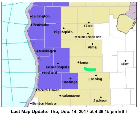
A winter weather advisory is in effect for Mason-Lake-Oceana-Newaygo-Muskegon-Ottawa-Kent-Allegan-Barry counties from 1am to 4 pm Friday. Lake effect snow expected. Plan on slippery road
conditions, including during the morning commute on Friday. Total snow accumulations of 2 to 4 inches are expected.
Snow will spread into the area late tonight, and become moderate to briefly intense for a few hours Friday morning and afternoon. Snow accumulations will not be very high, but most of it will fall in just a few hours. This will create hazardous travel conditions as fast accumulations cause slick roads and low visibility.
The most intense period of snow will coincide with the morning commute for cities in West Michigan such as Grand Rapids, Muskegon, Big Rapids and Kalamazoo. Snow will be less intense towards Lansing and Jackson, with peak snowfall there occurring during the late morning and early afternoon.

Hmmmmm…..Must Be Winter Time In The MITTEN….
Rocky Is Happier Than ……(fill blanks with whatever you WANT)….LOL…..Party on You Winter Lovin NUT.
Nice snows before Christmas! Like I said a week of so ago. We have a 99.9% chance of a white Christmas! Take it to the bank!
http://www.pivotalweather.com/model.php?m=gfs&p=snku_acc&rh=2017121418&fh=240&r=conus&dpdt=
Hey Rocky Hear is a BANK TUNE….
Cue—->>>>. Money – Pink Floyd HD (Studio Version) – YouTube
https://www.youtube.com/watch?v=cpbbuaIA3Ds
HEAR IS….My Youngest Daughter Lindsey”Rose” Mellema..
With Her LIVE Version of ” Jesus Loves Me” Wth HER Twist…
CUE —-.
https://m.youtube.com/#/watch?v=1kmQ-2LfCrI
Would love to hear her but I think the link is wrong. It doesn’t take me there.
Hmmm….Could Be That The LINK is From My Mobile Device.
Works on This End….Sorry Sister Sandy.
I’ll Try In The Near Future To Get You a link That Works.
GOD BLESS…..MERRY CHRISTmas To You & Yours.
Snowfall total from yesterdays MONSTER SNOW STORM = a whopping 7.5 inches! INCREDIBLE!
FYI….From Thee YARDofCUES….
I was Out In The Bone Chilling COLD LastNight/Early AM. ” Meteor Hunting”. Saw a Total of 8…..1 with a Nice Reddish Tine To It.
Also 1 with Massive Fragmentation…..And VERY VERY Bright With and Green Colored To It. My Cat Is Sitting On My Lap Right Now Batting at My Fingers. Got To Go…Looks Like More Snow.
Or Well…Tis The Season I guess …..stay Cued….For Some Cues Late NIGHT and Or Early FRYday Morning….God Bless U ALL….+….
What a great week of WINTER weather! The beat goes on!
http://www.weather.gov/images/erh/gis/LP_state_Snow.png
Winter advisory is coming for tomorrow 2-4 inches of new snow the snow keeps a coming .. thank you INDYDOG!
Preach it INDY! We may be seeing record setting snowfall this winter! Who would have thought?
The official low at the air port was 0° the record for today is -1° so that record will stand.
Slim
Lake Effect snow ongoing all day here. We are getting heavier and more snow today than we did on Tuesday under the “Winter Storm Warning”.
When the cold air like this arrives with a calm wind, we tend to get good snowfalls here as the snow bands gently move on shore.
Beautiful, big fluffy flakes falling!
Getting nice big fluffy flakes here as well.
Slim
I had a low of -3 here at my house. Love all the snow. It is beginning to look a lot like Christmas….
Climatology for today December 14th At Grand Rapids, MI
The average H/L is 35/24
The record high is 59° in 2015 the coldest maximum is 12° set in 1914
The record low is -1° set in 1943 the warmest minimum is 49 set in 1975
The most precip is 1.2” in 1975
The biggest snow fall is 5.1” set in 1907 The most on the ground was 15” in 1970
Last year the H/L 22/11 2.6” of snow fell and at 7 AM there was 7” of snow on the ground
slim
I had a low here at my house of -2° still waiting on the official low at GRR so far the low there is 0° and that is the coldest it has officially been here in Grand Rapids since March5, 2015. If they report that it got down to -1° or lower that would be not only the first time it has gotten below zero since February 28th 2015 and it would tie the record for today (Dec 14) The official reported snow fall at GRR yesterday is 5.9” GRR is now at 10.9” for the month and 11.5” for… Read more »
Good morning Blogers it’s cold out at thee YARDofBRICKS -1* right now we forget with clear Sky’s and a good snow pk how low the temps can go waiting for slim to let us know how close we made a record low this morning sitting about 10 inches of snow on the ground out at thee YARDofBRICKS not bad for early December …we picked up about 7 inches yesterday good job NWS on the Warning area waiting in more snow Friday winter weather advisorys coming 2-4 inches with some 5 inches snowy cold pattern continues .. stay warm thank you… Read more »
The closest official measurement to me said 6.4″, and that’s about what we got.
Our local TV met said we should stay in this pattern for the next week or so, and we can expect 2 or 3 similar, but smaller systems to come through before the pattern changes.
White Christmas, baby!
Still waiting on the official low for last night at GRR so far the low there has been 0° the record low for today (Dec 14) is -1° set in 1943. I had a low at my house of -2°
slim