THE WOLVERINES ARE NATIONAL CHAMPIONS!
Congratulations to the Wolverines for their resounding defeat of the Washington Huskies 34 to 13! I felt sorry for Penix in the last quarter facing the Wolverine’s relentless defence but hats off to him for hanging in there to the end of the game even though he was obviously hurt.
I still have the 1997 championship T-shirt hanging in my closet, now I’ll have to add a new one. Job well done gentlemen.
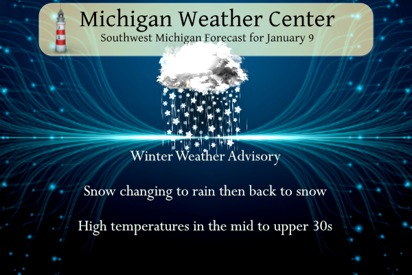
Accumulating snow this morning is expected to impact the morning commute. A very wet and dense snowfall is forecast, with 1″-4″ region-wide through late morning. An additional 2″-3″ of snow is expected near and north of M-20 this afternoon, while areas south of M-20 will mix with or change over completely to rain, making for sloppy conditions.
...WINTER WEATHER ADVISORY REMAINS IN EFFECT UNTIL 11 AM EST THIS
MORNING...

* WHAT...Wet snow. Additional snow accumulations of up to two
  inches. Winds gusting as high as 35 mph.

* WHERE...Portions of south central and southwest Michigan.

* WHEN...Until 11 AM EST this morning.

* IMPACTS...Plan on slippery road conditions. The hazardous
  conditions could impact the morning commute.
...WINTER WEATHER ADVISORY REMAINS IN EFFECT UNTIL 10 AM EST
WEDNESDAY...

* WHAT...Snow expected. Total snow accumulations of 3 to 5
  inches. Winds gusting as high as 40 mph.

* WHERE...Portions of central and west central Michigan.

* WHEN...Until 10 AM EST Wednesday.

* IMPACTS...Plan on slippery road conditions. The hazardous
  conditions could impact the morning or evening commute.
Forecast
Weather History
1930: A snowstorm drops from 4 to 8 inches of snow across southwest Lower Michigan.
1977: Record cold prevails during one of the most severe winters in Michigan history. Records include the 17 below zero at Lansing, 14 below at Grand Rapids and 8 below at Muskegon.
2015: Temperatures in the single numbers and lake effect snow showers create icy roads resulting in a 193 car pileup on Interstate 94 and both east and westbound lanes are shut down between Battle Creek and Galesburg.
On January 9, 2004, a band of lake effect snow formed over Lake Huron and dropped 4-6 inches of snow across the northeast tip of the thumb.
Also on January 9, 1997, significant ice accumulation on the wings of Comair flight 3272, crashed in a field outside Detroit near Ida, Michigan. The plane was en route from Cincinnati, Ohio. All 29 people, including 26 passengers and three crew members, were killed.
U.S.A and Global Events for January 9th:
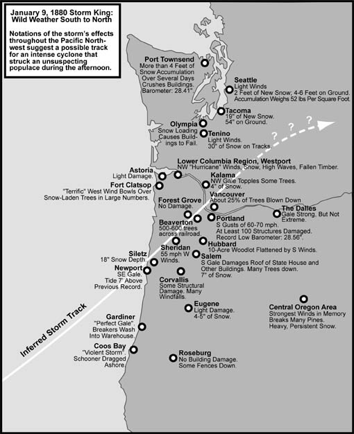
1880: A rapidly deepening low-pressure system produced powerful winds along the Pacific Northwest coast. While wind measurements were limited, there were widespread reports of wind damage. Click HERE for more information from the Office of Washington State Climatologist.
 2006: With cold air sweeping in from the Himalayas, New Delhi reports frost for the first time in 70 years with a low temperature of 0.2°C (32.3°F). The cold prompted officials to order all schools to close for three days. Click HERE for more information from CBCNews.
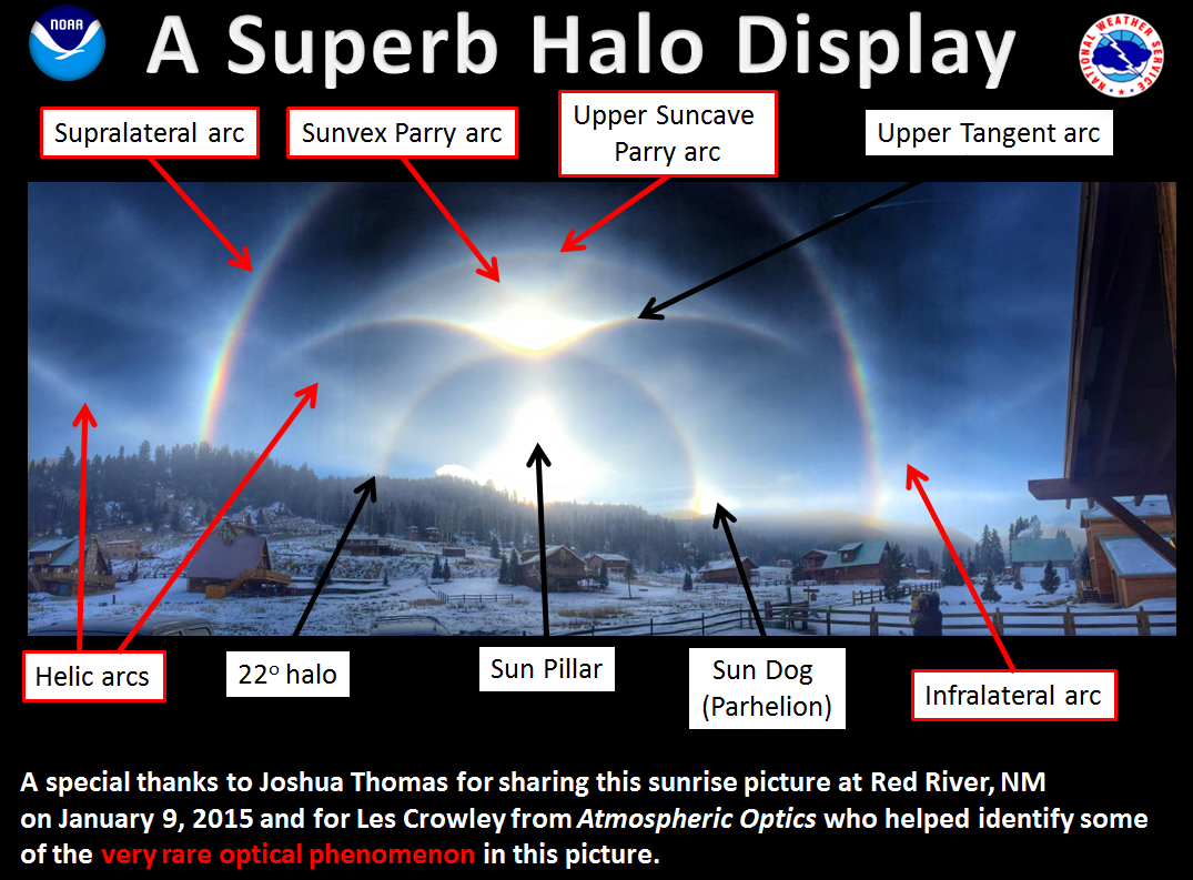
2015: The halo picture below was taken by Texan Joshua Thomas in Red River, New Mexico. Click HERE for the Facebook post by the NWS Office in Amarillo, Texas.
Forecast Discussion
...Snow and Rain Today...

The forecast is pretty much going as expected and see no need to
modify the current headlines.

Radar shows light snow making steady progress northward across the
cwa, but taking an extra hour or two to reach the ground given the
very dry 00z DTX sounding. Regional radar shows abundant
precipitation to the south and west, but the dry slot was evident
moving through Missouri and western Illinois.

Water vapor showed the well defined upper low near Tulsa with the
surface reflection over southwest Missouri. Given the strong lift
with the system, we`ll see travel impacts this morning due to snow
prior to a mix with and changeover to rain across parts of the
southern cwa.

Latest HRRR guidance lands in the middle of the other models in
moving the rain/snow line northward to a Grand Haven to Alma line
this afternoon, North of there, the precipitation should be all
snow. South of there we`ll see the snow gradually mix with and
change over to rain as the morning progresses, with locations such
as Grand Rapids seeing the mix with rain develop around 1 PM.
We`re likely to see the changeover back to snow by mid afternoon
in Grand Rapids...and eventually the southern cwa during the
evening.

Expected snow totals didn`t change much from yesterday with 2-3
inches in the southern cwa, 3-4 near I-96, and 4-7 north toward
US-10.

Models are pointing toward the dry slot encroaching on the
southeast cwa late this afternoon and early evening...roughly
south of a South Haven to Alma line. Look for precipitation to
diminish quite a but in this area. However, once it moves east and
colder air begins to flow into the cwa on the back side, light
snow will once again develop and continue overnight before
diminishing Wednesday morning. There could also be some lake
enhancement Wednesday as h8 temps fall to near -8c creating lake
delta t/s around 13c. Snow showers are expected Wednesday but
little if any accumulation is expected.


.LONG TERM...(Wednesday night through Monday)
Issued at 319 AM EST Tue Jan 9 2024

- Confidence for an impactful storm is on the increase for Friday
  into Saturday

The latest runs of the models continue to show a very deep storm
system to potentially impact the area during this timeframe.  The
mid level closed low is shown to arrive Friday night and the
models are in decent agreement with its timing and strength. The
500 mb height anomalies are pushing 300 meters, which is
considerable. Similarly good agreement with the surface low track
and strength with the center near Detroit 09z Saturday with 980 mb
or lower values. This is favorable location for a swath of
heavier snow into our CWA. This system will tap moisture from the
Gulf and Atlantic and draw down some arctic air from the Canadian
Prairies. Warm and moist air advection ahead of the system Friday
results in developing snow over the CWA. A coupled upper level
jet is shown to enhance the widespread lift here in MI Friday
night. The snow will likely intensify then. As the storm pulls
away Saturday, the synoptic snow will give way to some lake
effect. Multi-run and mean 24 hour snowfall values from the
ensemble and deterministic models for GRR support an increased
risk for heavier snow. Similarly the mean gusts from the ensemble
outputs are topping 30 mph. Based on all this, confidence for
moderate or greater impacts is unusually high for this far out. As
we go through the weekend, one difference is how quickly the core
of the arctic air arrives. The Canadian holds off the bulk of
arctic air until Monday into Tuesday, suggesting it will await for
another wave to bring it down. The ECMWF and GFS draw the arctic
air in by Sunday.

- A period of snow for Wednesday night into Thursday

Models show a mid level shortwave and associated surface low
tracking eastward through the CWA during this timeframe.  Forecast
soundings are supportive of this being a snow event for the region.
The best lift and deepest moisture occurs around 12z Thursday. Low
level convergence at 12z Thursday is the strongest west of US-131
and some moisture from the lake is shown to get drawn into this
system.  Thus, we may see some impacts from this wave closer to the
lakeshore.  The Thursday morning commute is the period where this
is most likely to happen.
WEATHER ALERT>>>>>>>>>Get ready to rock! For those out there that are still slow walking the Friday storm you need to wake up! A major snowstorm will be hitting West MI on Friday/Saturday! Take it serious and start preparing now! The major hazards are; heavy snow. low visibility, strong winds, possible power outages and very bad travel conditions! Don’t say that were not warned!!
The 18z EURO gives parts of Mich Wisc Iowa and Illn a crushing Blizzard Friday per storm Chaser Adam Lucio GREAT SCOTT!! Stay tuned….INDY
What? You mean winter is here? You mean it won’t stay below normal snowfall and above normal temps all winter long like the warm weather fanatics keep talking about, you mean we are seeing a pattern change just like I predicted about 2 weeks ago, you mean we might see the polar vortex after this storm, you mean we might get literally buried in snow! How is that possible?
We are still getting pummeled with snow! Incredible storm!
Let it snow let it snow let it snow.
InDY
The. 5 day EURO is still rocking!
https://www.pivotalweather.com/model.php?m=ecmwf_full&p=sn10_acc-imp&rh=2024010912&fh=120
Whew roads are very slippery here. Saw a couple slide offs as well. Coming down at a good clip, a sleet and snow mix
Yes and this is why the NWS extended the WWA! Great call on their part! This was a great WWA! Drivers need to slow down and stop tailgating on slippery roads!!!
Yea that was quite shocking, I was not expecting roads to be bad with how warm it is. Definitely stay home!
As of 5:30 PM the official snowfall at Grand Rapids was 2.5″ Here in MBY my 7PM measurement was 2.0″ of wet heavy sloppy snow. It is still snowing here at this time with a temperature of 33.
Slim
That means the NWS and RDB were 100% accurate again! WOW!
Temps are falling outside I can feel the cold through the window what a overachiever snow storm today its been snowing most of the day no rain out at thee yardofbricks… DDDD INDY
In regards to the possible storm Friday/Saturday, it’s still to early to know how things will pan out. The NAM and Euro show us receiving a major snowstorm with lots of wind and a deep low pressure dropping into the 960s. The EPS (group of European Ensemble members) agree on a deep low track near Toledo. However the GFS is a little more tame and puts the low further SE and the heaviest snow SE of Grand Rapids towards Detroit. It also shows the low pressure not quite as deep. Lots to iron out still.
Kyle you hit it right on the nail. It is still too early to tell how the next possible storm will play out. Any time you see a extreme low pressure like the Euro has for that system you have to take it with a grain of salt.
Slim
On a side note the deeper the system generally the more NW it should be.
Slim
This storm means business and with the vast majority of all the models giving us a major snowstorm, I like our chances! Even the ever trusted RDB model gives us 6 to 12 inches of snow! Accuweather gives us 12 to 18 inches! Let’s bring this one home and enjoy the snow!
At this time it is raining at my house. Forecast here is panning out as expected.
We appeared to barely miss the rain/snow line. And got a solid 4.5” and it’s coming down again. A very heavy wet snow. Almost impossible to shovel.
We are getting pummeled with moderate to heavy snow again! Based on the radar it may last awhile! Minimal rain here! Basically all snow baby!
Currently more snow falling out at thee yardofbricks wow what a storm….INDY
Going on a limb here I say Winter storm watches coming tomorrow afternoon or evening for Friday!! Then on Thursday winter storm watches become Winter storm warnings like the Christmas blizzard the NWS will get this out early get people prepared now!! Windchil Advisorys by Sunday this is a big winter event on the way!! Stay tuned INDY 😉
Definitely has potential!
The RDB model was spot on with 2 -4 inch estimate for GR! Good job but the NWS – definitely WWA worthy! Incredible!
Currently on the north side of Lansing in the town of DeWitt and it’s 34 degrees here with a mist. There is less snow here than back home at my house in Portland.
Advisory extended till 7am tomorrow for Ottawa, Kent, Ionia and Clinton Counties and points north. Additional accumulations of 1-4” expected.
We transitioned to rain shortly after noon. 35 here still. Almost all of what little snow we rec’d this morning is now gone.
I see NWS Gaylord downgraded the winter storm warnings in northern Michigan to winter weather advisories. The expected total snowfall has been cut in half from what was expected earlier this morning.
As expected, the SE US is the area taking the brunt of this monster system. Lots of tornado and flash flood warnings.
Indianapolis Indiana broke a record today lowest low pressure ever recorded in January from this storm beating out the blizzard of 78!! That’s crazy thats.a big low pressure out there!! INDY
Getting a light snow/rain mix here with a temperature of 34. The total snow on the snowboard is 1.5″
Slim
Not sure if we will be transitioning to rain… still snowing here. The lull is approaching and may stop before it’s too warm for rain
Winter storm watches coming!! INDY
Probably issued on Thursday!
I have picked up 1.5” so far at my house.
Incredible snowfall rates as we speak! We are getting plastered with Snow!!!
Here is NOAA’s definition of Heavy snowfall. Heavy Snow This generally means… snowfall accumulating to 4″ or more in depth in 12 hours or less; or snowfall accumulating to 6″ or more in depth in 24 hours or less In forecasts, snowfall amounts are expressed as a range of values, e.g., “8 to 12 inches.” However, in heavy snow situations where there is considerable uncertainty concerning the range of values, more appropriate phrases are used, such as “…up to 12 inches…” or alternatively “…8 inches or more…”. Heavy Snow Warning Issued by the National Weather Service when snowfall of 6… Read more »
Then by those definitions MBY has hit heavy snowfall. My wife works at the school and they didn’t cancel in anticipation of it turning to rain. But now there is 4-5” of snow and it’s still coming down. The buses will have some trouble on the rural backroads around us.
Currently 0 visibility GR right now I would imagine that’s heavy snow ….Crazy….INDY
Come on Indy. I am looking out the window right now and the visibility is more like a half mile or more.
Slim
2.5 inches and getting heavy snow as we speak! What a storm!
Definitely a overachiever especially when the NWS called for rain now lol….INDY
It looks like the Grand Rapids area (at least the north to northwest side) has stayed on the colder side of the system.
Slim
Nothing but snow…had heard we’d be all rain by now.
Getting really good sized snow fakes here at this time. For anyone who wants to know here is the general definition of snowfall by visibility. the standard relationship between snowfall intensity and visibility used by many national weather services (1/4 mile or less visibility corresponds to heavy snowfall intensity, between 5/16 and 5/8 mile corresponds to moderate intensity, and greater than 5/8 mile corresponds to light intensity)
Slim
Ah good data Slim. I’m not sure the exact visibility here, but at one point the weather app said “heavy snow”. Back to a more moderate rate right now
Getting moderate snow falling here with larger flakes. Still just one inch on the snowboard. It is a very wet snow and the roads are either wet to snow covered. Temperature is 33.
Slim
It hasn’t stopped snowing since 5am here, but it’s a moderately light snow. Total accumulations for us are 4” and still climbing.
Very heavy snow here, roads are quite slippery. Finally looks like mid winter!
Getting heavy snow out at thee yardofbricks….. What a storm…. wow to the wow! INDY
We were dropped from the WWA, which is the correct call. It has not snowed here in at least the past 90 minutes. Roads are wet, but no snow on them. Maybe a 1/2″ of snow on the grass (think more green than white). 35 degrees here currently.
We are getting big flakes right now!!! Very wet flakes.
Breaking Weather Alert>>>>>>the preliminary RDB model snowfall for this weekend storm is 6 to 12 inches! Get prepared and stay tuned for later updates!
I seen Slim mention 5 days before the blizzard of 67 the forecast was light snow. Well the blizzard of 2011 worked in similar fashion. Well let me tell you how 2011 played out ———————— Jan. 27 the forecast was for dry conditions the day of the groundhog blizzard. Local meteorologist stated “no big storms in 8 day forecast” Jan 28: Watching a storm system that will miss us to the south and go up the east coast Jan 29: Watching a mid week storm that looks to barely miss is to the south across Indiana/Ohio 24 hours later on… Read more »
Moral of the story – meteorology is not a perfect science. Sometimes they nail it, sometimes they fail it.
My Dad always said he should’ve been a meterologist … he gets paid whether he is right or wrong. LOL!!! My Dad worked outside, so we would ask him what he thought th eweather was going to be like… miss that.
That’s a good one. Your dad was a wise man. 🙂
LOL!!! He would’ve laughed if I could tell him!!!
Took today off after the big game last night! Sitting here with a smile on my face basking in the glory watching the snowflakes come down! Great day!!
Who has it better than the Wolverines?
They earned it. Phenomenal team.
Nobody!! Absolutely Kyle!
Just took a snow depth measurement and there is now 1″ of snow on the snow board in MBY. Getting light to moderate snow at this time with a temperature of 32. For the 1st time this winter season the driveway and road are snow covered
Slim
Watching Ryan Hall live now. He’s showing models for this weekend’s storm. It shows a 972mb low over the Michigan/Indiana/Ohio convergence – i.e blizzard conditions for Chicago and SW Michigan.
Keep in mind, Monday will be the halfway point of meteorological winter.
That is interesting. Right now he is talking about tornadoes down south.
Slim
We are getting absolutely plastered with snow! Wow!
Heavy snow in GR as we speak!
The snow has picked up but more like “snow” or borderline “moderate” snow but not yet heavy snow. Heavy snow is snow falling with a visibility of 1/4 mile or less.
Slim
While it’s not saying much, this is the most snow I’ve had at my house all winter so far. Roads starting to get snow covered as snow rates have increased.
Roads are slick please be safe great call NWS on the Winter weather Advisory thank you!! INDY
Rock on INDY and get ready for the WSW for Friday night! It is going to be wild! Incredible!
Let’s give a current report out at thee yardofbricks moderate snow falling with wind who knew?? INDY
Moderate snow falling here but no wind in fact it looks to be calm at this time.
Slim
I will be taking any and all bets about this weekends storm! This is the big storm that signals a major pattern change! The GR area will be seeing 6 plus inches of snow from the weekend storm and maybe up to 12 inches! Get ready!
Lots of comparison talk out there to the blizzard of 78!! DDDD!! Stay tuned….INDY
WOW!!!
You know I have always wonder just how (or if) the current models would handle a system like the past storms of 67, 73 and 78 heck even the 93 storm. But I will not be too concerned until later in the week as to how this one will play out. There is just too much hype now days for some reason. If I remember in 1967 the forecast at 5 days was for light snow. I was in Ann Arbor just before the storm in 1978 and the Detroit radio stations were calling for a storm on the night… Read more »
Hype = ratings = $$$
Mark you got it. Right now the snow has tapped here and now back to just light snow falling.
Slim
Yeah, we’ve had a couple of brief moments of moderate snowfall. Snow is on the ground, but the grass is not covered yet.
Over an inch of snow already and the wind and snow is picking up as we speak! The storm for this weekend will be a monster! Make it down and make sure you are prepared!
While it is too early to say how the Friday to Saturday system will play out just remember a few days ago this system was said to be a “huge” storm and so far it has been not much of anything and at this time there is less than a half inch of snow on the ground here in MBY.
Slim
I could not disagree more!
The official H/L yesterday at Grand Rapids was 34/31 there was a trace of snowfall and no sunshine. The official snowfall for this season at GRR as of yesterday was at 3.5” that is a departure of -30.6” below average as of this date. For today the average H/L is 31/19 the record high of 57 was set in 1939 and the record low of -14 was set in 1977. The wettest January 9th was in 1946 with 0.85” (all rain) the most snowfall of 8.0” was in 1930 The most on the ground was 19” in 1999. Last year… Read more »
So far this snow event has almost been a no show here in the Grand Rapids area with some light snow and a temperature of 33 there is just 0.2” of snow on the ground.
Slim
Who has it better then us NOOOBODY!! 💙 INDY
Who has it better than us with a major/monster snowstorm heading right at us this weekend! It could be the M word!
GO BLUE INDY!!!!!!! NATIONAL CHAMPS!!!!
Go Blue!!!!!
Slim
about 1″ on my deck railing, with light snow still falling… great game last night, but I’m paying the price for being up almost 2 hours past my bed time! Glad my old snow blower will get to stay in the garage for this event, but the weekend may force me to coax it to life.
Way to go, Blue! A good defense usually prevails over a good offense. Michigan clearly had the better defense (understatement). They should have pulled Penix. Looked like he had a broken rib. So glad the the B1G finally won a championship – even better that it was won by a team from our home state.
A few flurries here. Not much to speak about. 35 degrees currently so hardly anything is on the ground.
This so called 1st system has really been a bust NW of GR as well. Just 0.2″ of snow on the ground. So much for a WWA for this one.
Slim
The B word!
Need I remind you that the event just started and is far from over! It looks WWA worthy to me! We are getting pounded with snow as we speak and the roads are slippery! Keep in mind the forecast form the NWS was for GR to see about 1 to 3 inches of snow! This is happening!
“Traveler’s Advisory” 🙂