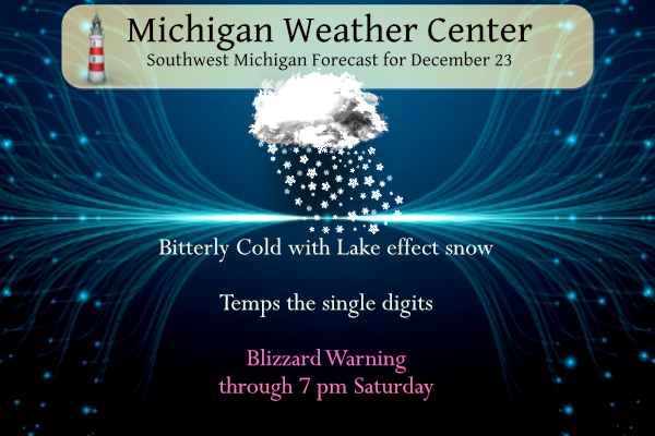
First, happy birthday to my wife and SS. This will be a great day for festivities indoors, over the phone, or via video conference. Temperatures have been falling since last evening from just above freezing to our current 7° at 5 am. Temps will struggle to rise into the low teens today with blizzard conditions for the lakeshore counties. I would suggest remaining indoors. If going outside dress in layers and cover all exposed skin. I wear a balaclava, thermal undies, insulated pants a hoodie then my Cartharts.
I will update this blog as the day proceeds…
...BLIZZARD WARNING REMAINS IN EFFECT UNTIL 7 PM EST SATURDAY...

* WHAT...Blizzard conditions expected. Total snow accumulations
  in excess of a foot in many areas. Winds gusting as high as 50
  mph.

* WHERE...Portions of southwest and west central Michigan.

* WHEN...From now until 7 PM EST Saturday.

* IMPACTS...Travel will likely become very difficult to impossible
  today and tonight and even into Saturday. Widespread blowing
  snow will significantly reduce visibility. Gusty winds could
  bring down tree branches and cause power outages.

* ADDITIONAL DETAILS...Snow...blowing and drifting snow and cold
  temperatures are all expected through Saturday. Blizzard
  conditions will develop early this morning and continue tonight
  and Saturday. Travel will be treacherous to life threatening due
  to icy roads and near zero visibility at times due to both
  falling and blowing snow. If you do not have to travel your best
  option is to stay home. Whiteout conditions will be frequent.
  Snow accumulations in excess of a foot are expected in many
  areas by Sunday morning. Given the variability of lake effect
  snow... which will dominate much of this event... you could very
  well see more or less snow depending on location.
...WINTER STORM WARNING REMAINS IN EFFECT UNTIL 1 AM EST
SATURDAY...

* WHAT...Whiteout conditions expected at times due to falling
  and blowing snow. Total snow accumulations of 4 to 10 inches
  by Sunday morning. Wind gusts as high as 50 mph.

* WHERE...Portions of central and south central Michigan.

* WHEN...From now until 1 AM EST Saturday.

* IMPACTS...Travel could be very difficult. Widespread blowing
  snow could significantly reduce visibility. Gusty winds could
  bring down tree branches.

* ADDITIONAL DETAILS...Wind driven lake effect snow showers will
  continue today through Saturday as well as drifting snow and
  cold temperatures. Snowfall totals across the warning area will
  range from 4 to 10 inches. The main component to this event
  will be the wind. Winds gusting in excess of 40 mph will create
  occasional whiteout conditions. The changeable weather will make
  for treacherous travel. The worst of the conditions are
  expected later this morning through Saturday.
Forecast Discussion
- Blizzard conditions through Saturday -

No headline or significant fcst changes are needed early this
morning as our previous shift forecasters set the table
exceptionally well with an excellent forecast and headline
decisions. The blizzard warning remains in effect through 7 pm
Saturday for our western two tiers of counties with a winter storm
warning for our eastern two tiers of counties.

The low pressure system over Lake Erie early this morning will
continue to undergo rapid intensification as it moves ene to be
centered over Lake Ontario by 12Z (00Z EPS and overall guidance
trends continue further east with this system). WNW flow lake
effect snow showers will continue to develop early this morning
and increase in coverage and intensity later today as h8 temps
continue to plummet aided by increasing low level omegas along
with a more unidirectional wnw wind profile w/height.

In addition wind speeds will continue to ramp up as the pressure
gradient tightens between the system off to our east and strong
high pressure ridge across the northern Plains. We expect
frequent wind gusts in the 40-50 mph range from mid to late
morning through tonight and still to around 40 mph or so Saturday.
Winds of this magnitude will result in scattered power outages
mainly this afternoon into tonight. Apparent temp values will
fall to ten to fifteen below zero today through Saturday morning.

Persistent convergence with strong low level omegas in the
1000-850 mb layer (in other words through the dgz) will favor the
triangle from KMKG to KGRR to KAZO and points westward from there
for heaviest lake effect snow showers today and even more so
tonight (although les will be carried far inland by the very
strong winds). This strong low level omega will also be focused
across our lakeshore counties throughout the duration of the event.
Strong low level convergence and omega tomorrow is particularly
robust near to north of the I-94 corridor where snowfall rates in
excess of an inch/hr at times are expected.

Due to all these aforementioned factors and significant blowing
and drifting of snow dangerous travel conditions are expected
today through Saturday.

We expect storm total snowfall through Saturday evening near to in
excess of a foot near a line from KRQB to KGRR and KAZO with
locally higher amounts to near a foot and a half possible along
and west of US-131. Relatively lighter accumulations are forecast
further east. Snow will be very difficult to measure b/c of all
the blowing and drifting.

- Gradual moderating trend of temps mid to late week -

Lighter lake effect snow showers and very cold temps are expected
Sunday. A low pressure system moving se from the northern Plains
states will most likely stay south of our area Monday. An upper
ridge will briefly build in and bring milder temps by Wednesday
and Thursday. South to sw flow waa will also bring potential for
a few rain showers late in the week.
GR snowfall total yesterday was 7.5 inches = daily record! The snowfall in GR on Thursday was 3.8 inches, so as of midnight yesterday the storm total is already 11.3 inches! It looks like Wood, the NWS and the RDB are rocking and accurate, despite the naysayers! Wow to the wow!
Only 108 Consumers Energy outages reported statewide. That is very surprising to me.
Bring it!
 ?auto_optimize=low
Been an easy winter so far, no long term cold and when we’ve gotten snow, it melts a few days later! Days getting longer now and spring will be here before you know it!
Wow to the wow wow!! Historic warm high temps coming next weekend! Who would have thought?!?! And after that temps in the 40’s as far as the eye can see! I love these mild winters! Global warming Rocks!!
https://weather.com/weather/tenday/l/b523690bfd952b86fef3627c919dd9855281a8da16b83c10bdd381c64ae12cbc
9 PM update. As of 6PM the official snow fall total for today at Grand Rapids was 4″ The official snow depth at was 7″ Here in MBY the average snow depth is 8″ the wind has put a crust to the snow. The deepest depth is 16″ It is still snowing and blowing but the flake size is very small that and the wind has held the snow amounts down. The temperature is up to 7 it was down to 5 earlier. Heavy snow has been reported in 10 of the last 11 hours at GRR. At Muskegon they… Read more »
Lol!! 4 inches, gonna be awfully hard to get to that 15 to 20 inch total Kirkwood was wishcasting for. Funny GR will end up with around 8 inches total for this “storm” but somehow Rockford will get 18” of snow! LOL!!! Give me a break! Historic storm, that’s rich, we got more snow a couple weeks ago, than this will produce!
The wind and snow just keep coming and coming and coming This is a historic snowstorm despite the usual naysayers downplaying the storm! Wow, just wow!
The north south country roads out by me are essentially drifted shut. No way your getting any sedan or SUV out here. Definitely need a truck
Wow!
Let it snow let it snow let it snow!! INDY!!
GR seasonal snowfall over 50 inches already! What a great start to winter!
The Blizzard conditions continue here at my house with heavy snow and blowing snow. The current temperature here at my house is 5 with that heavy snow. I will take some snow measurements later.
Slim
You should be near 10 to 12 inches by now!
This is an historic winter event! Be careful out there!
Wow to wow, what a storm! GR is still getting pummeled! Cold, snow, wind, blizzard, drifts, etc! The three entities that have done a great job forecasting this event! The NWS, Wood TV 8 and the most accurate model around the RDB! Details forthcoming! Incredible!
Currently “heavy snow and blowing snow” with a wind chill of -17 in Grand Rapids. The wind is really cranking now!
Also Reed Trimmer’s footage from Buffalo is absolutely crazy. It looks like a hurricane with 10 foot storm surge (a siege on Lake Erie)
So, going forward, our surface storm is still deepening and is expected to deepen another 10 mb yet by Saturday morning as it slowly progresses toward Hudson Bay. This keeps us well with the deep circulation of this system. There is an area of deeper mid level moisture over Upper Michigan into central Ontario that is rotating around the system. Now that the 500 mb low is moved east of Southwest Michigan that area will rotate south toward us. Regional radar shows an area of better radar returns under that deeper moisture aloft. This means more snow tonight that we… Read more »
HAPPY BIRTHDAY MRS VANLENT!!!
Buffalo is reporting 0 visuality.
https://forecast.weather.gov/MapClick.php?x=77&y=167&site=buf&zmx=&zmy=&map_x=77&map_y=167#.Y6YPk3bMK5c
Slim
Wow to the WOW!!! Mega blowtorch on the way! Get prepared now!! Keep it ROCKIN!!
Looks warm and wet for at least 2 weeks at the end of December and the start of January.
Slim
Mid afternoon update. As has been reported here in Grand Rapids we are having Blizzard conditions. The current temperature here is 6 and while the winds are not as strong as has been in the forecast it is windy enough with the snow an the ground and the snow that is falling to create whiteout conditions from time to time and less that a 1/4 mile visibly. I took a unplanned trip to Meijer the roads are snow covered and icy but very much passable for the most part at least with 4×4. Meijer was busier than I thought they… Read more »
How tall are the drifts in your area? You’ve had more snow that we have had here.
The winds have not really been that bad here and thus the drifts are less than expected maybe around 12 to 18 inches. It has been snowing all day but not really that much new snow either. Hard to measure but I have a average of 9″ on the ground about 6″ of that is new snow. I know the official winds at GRR have been gusting much higher than what they seem to be here.
Slim
Yeah, I was just looking at hourly reports from our CWA. We’ve had very little snow today and the drifts are about the same (12-24″). Y’all have had more snow, but it appears that the wind has been stronger over here. We’ve had 40+ mph gusts since sunrise.
Gas not being delivered till monday highways being closed many business closed county plow trucks being pulled people being told to stay home power outages 5 to 6 foot drifts welcome to the Christmas Blizzard 2022 be safe everyone … INDY
Well this is going to be a mess when everything melts at once with rain on top of that:
.UPDATE… Issued at 1222 PM EST Fri Dec 23 2022 Since blizzard conditions (for the National Weather Service) is 3 or more consecutive hours of winds frequently gusting to 35 mph or more and visibilities near to under 1/4 mile, I would say our warning has verified. MKG has had that since 3 am this morning, Holland since 8:30 am, as had South Haven (LWA), and Grand Rapids has had it for about an hour so far. The latest model runs including the HREF, show the strongest winds late afternoon into early this evening (surface low continues to deepen), the… Read more »
Yes the NWS and the RDB have been very accurate so far and I will be interested to see the actual snowfall for GR today. Yesterday they had about 4 inches and today probably at least another 5 to 6 inches, so a great storm so far!
Interesting. I don’t recall them ever putting a justification in writing.
It seems that snowfall is obviously underperforming so far, but wind chills around -10 to -20 and the high winds are making driving terrible. It looks more like a ground blizzard to me (and probably still under blizzard criteria). Either way, this is a top 5 snowiest winter so far at Grand Rapids.
There, I knew my comment would trigger Rocky for a few rapid fire responses! For being such a snow lover that he is, I thought he would be out from 6 am to midnight making snow angels, snow forts, sledding, and so on. Especially with this snow cover being short lived with the big blow torch coming later this week.
Bring on the blow torch!
Wow, GR is getting pummeled with snow right now and no sign of any let up! Wow, just wow!
Currently wind is gusting to 40 to 45 MPH in the GR area! Incredible!
What a storm! The RDB snowfall prediction is right on target and the wind and snow is picking up! This really is a big storm and so far the NWS is spot on! Wow, just wow!
Wow, pretty low standards for Blizzards these days. Hasn’t really done anything in Northern Kent here this morning. A little breezy an maybe 4 or 5 inches of snow from overnight. A WWA would have probably been more appropriate. Just makes me laugh thinking back a couple of days ago with Kirkwood trying to say 15 to 20 inches of snow for our area! The overhype machine Kirkwood. He was still trying to sell that this was some sort of generational storm today at noon! Then he was nearly in tears when he was talking about the 50 degree temps… Read more »
Blizzard is kicking it hard right now im thinking this is worse the ground hog day Blizzard be safe everyone….INDY
Yes a monster!
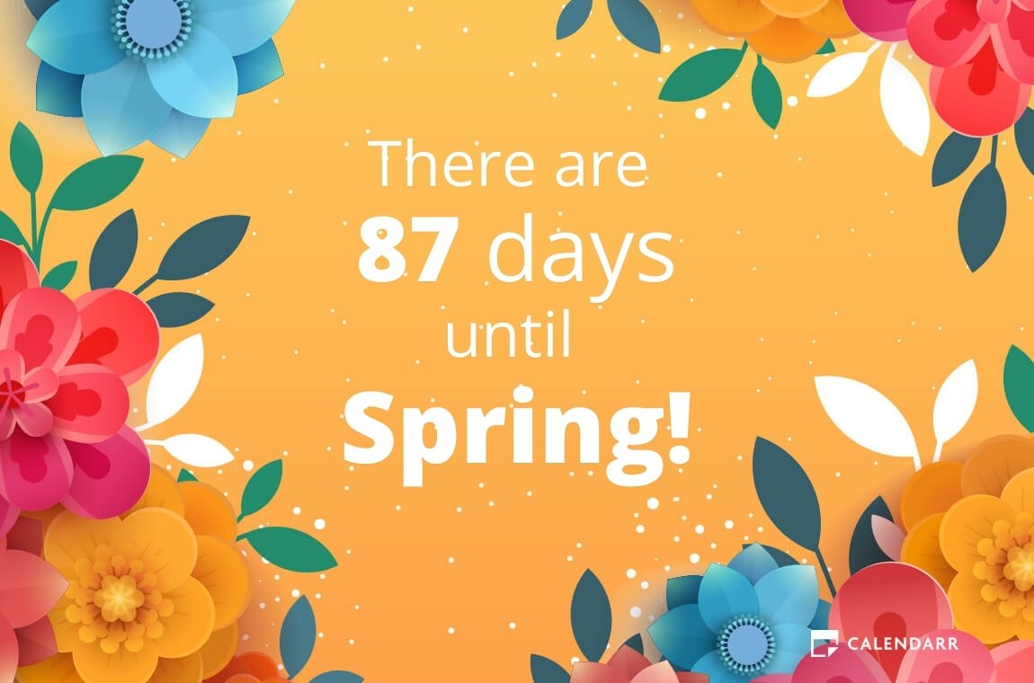
The days are starting to get longer into spring now. Let the warm up begin!
The winter solstice is one of my favorite days of the year because we finally start to gain daylight. IMO the second half of winter is the “better” half of winter because it’s much lighter
Looking ahead it now looks like there is a increasing chance of a major warm up for New Years. There is a chance that we could get into the 50’s for a major melt down.
Slim
Our local guy this morning said that we may lose all of our snow by New Year’s Day.
Great news, the wind is out of the West, so GR will see steady accumulating snow all day into tonight! Wow, just wow!
Mid day update from MBY. Not too much new to report. Light snow and blowing snow still falling. The snow flake size is very small just as I expected and while the winds are not as high as in the forecast here at my house there is still moderate blowing snow at times, Have not see the visibility here drop down to the 1/4 mile range. I have around 5″ of new snow on the ground and one drift of just under 12″ I did use the snowblower and it made quick work of the driveway. At the current time… Read more »
Looks like the worst of this system is to the north and east of us. Much more snow up north and a 79 MPH wind gust recorded 90 minutes ago at the east end of Lake Erie. The tail end of the system snow is now in the thumb and moving quickly to the NE. We have maybe 4″ here but it really hasn’t snowed here since 6-7a. As expected, we have areas of bare ground out back and two or so foot drifts around the house. I wonder if any of the LE will make it this far inland?
That is a good question the snow here is very fine so what falls can blow around a lot. I have about 8″ on the ground but more like 5″ of new snow and I have a drift by the back fence that look to be around a foot.
Slim
Yes, but it will be on the light side!
Muskegon is over 12 inches of snow now wow …INDY
Nice and we will be seeing many totals over 12 inches!
Awe… Michael Thanks for the Birthday wishes!
Please tell your wife Happy Birthday!!!
Happy Birthday SS and Mrs. v!
Happy birthday to you and Mrs. VanLent!
Happy Birthday to you both!
Slim
Thanks everyone!!! I appreciate it!!!
HAPPY BIRTHDAY *SS*
Thank you Sandy!!
Wind is rocken hard out in my hood snowfall rates are picking up to the Christmas Blizzard is in full force love it stay safe everyone…INDY
Hey Indy, have you ever noticed the naysayers don’t even understand how a multi day snowstorm works? We are right track for the predicted snowfall totals! This storm means business and it is just getting reeved up! Keep it coming!
YES!!”I would imagine will be seeing pur 5th and 6th days now with record snowfall already this season so yes this is a serious event we are having….INDY
What a storm! The snow just keeps coming! Gr is already approaching 7 inches and counting! Wow!
The storm is over. That’s lake effect.
I saw a nationwide wind chill map. It’s amazing how much the Great Lakes are insulating us. The map showed colder wind chills in far southern states than here in Michigan.
That always happens. In the spring and early summer parts of Michigan are colder than areas to the west.
Slim
I don’t see wind chills in Alabama, Kentucky, and Tennessee that are colder than Michigan very often.
Pretty small little storm. A general 2-5” in Southern Lower Michigan.
Yeah just a little storm. Multi car pileup freeway closures and m-40 is closed in a spot that normally drifts over in big event. I wouldn’t call that small. What a joke!
Don’t fall for his trolling! No matter how big and bad the storm is he always says it is no big deal and less that was forecasted! Same ol same ol!
M-40 near Hamilton is closed. I remember that closing in the 2013-2014 winter I think
That has always been a bad area. That used to happen a lot.
Slim
Multi car pileup on I-94 near Watervliet. Sadly there are injuries.
I-94 closed due to a pile-up: https://twitter.com/ChicagoMWeather/status/1606300757711474688
It hasn’t snowed here in four hours. Windy and cold, but the visibility is a non issue – probably a mile or more.
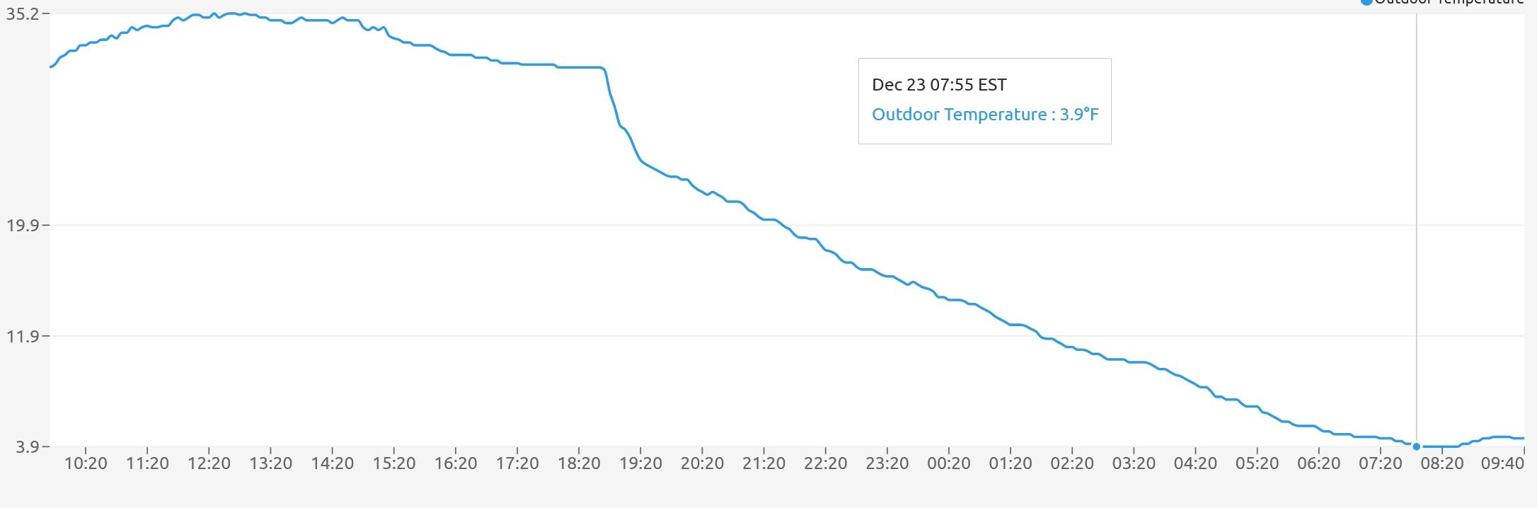
We have 4 degrees at this time with moderate snow and blowing snow. Below is the graph from my weather station from yesterday to this morning.
Added a fitting song to the end of the post…
LIKE
My kids are safely home from college, I have hot coffee and the bird feeders are full. Bring it on! Merry Christmas everyone!
Just drove a mile to get a coffee… roads are all snow covered and icy and visibility is poor (but not blizzard levels yet). It’ll be interesting to see conditions this afternoon once things worsen
Since (hopefully) we’re all stuck inside, how about a little weather humor? When you send the sports guy outside for live weather reports:
https://www.youtube.com/watch?v=lEriXBInRlY
That was funny.
Slim
You are now in charge of the weather humor dept. Congrats 🙂
Breaking Weather>>>>>the winds and snow will only increase today! This is a monster storm with no sign of let up or weakening! Get prepared for a blizzard baby!
Looking back at yesterday the official H/L at Grand Rapids was 34/15 there was 0.37” of precipitation and their report as of midnight was 3.8” of snow fall. There was 12% of sunshine yesterday. For today the average H/L is 34/27 the record high of 60 was recorded in 2015 the record low of -11 was set in 1989. The record snow fall of 5.9” was recorded in 2008. At the current time the snowstorm event is not all that far from a typical snow event in this area.
Slim
I’d say I’ve gotten about 4” of snow at my house. The winds are cranking up and getting lots of blowing snow.
So far the wind here has not been that bad. It might be similar to what I had during the last snow event. But it is much colder.
Slim