
We have had a lot of boring weather this winter, today will be no exception. Yesterday we had 42° for a high temperature with a fair amount of sunshine as February has outperformed the rest of the winter months in that department. We should see some sun again today before the clouds move back in. High temperatures each day this week will climb above freezing. Two main chances for precipitation include Tuesday and Thursday: mostly rain, though we can’t rule out some snow or freezing rain mixing in especially to the north.
A 7.8 magnitude earthquake that hit Turkey and Syria this morning is tied as the strongest the country has experienced in more than 100 years of records, according to the United States Geological Survey (USGS). The USGS said an equally powerful 7.8 magnitude quake that hit eastern Turkey in 1939 resulted in more than 30,000 deaths. For the latest updates: https://www.cnn.com/middleeast/live-news/turkey-earthquake-latest-020623/index.html
Grand Rapids Forecast
2 6 grrLansing Forecast
2 6 lanKalamazoo Forecast
2 6 kzoForecast Discussion
- Precip Chances Increase Late Tonight/Tue Morning With Gusty Winds

High pressure will slide over the region early this morning with
quiet conditions lasting through much of the day today. A deepening
low pressure system centered to our north over the Southern Hudson
Bay will extend a cold front southwards into the Great Lakes Region.
Ahead of that cold front, stronger northward advection of warm and
moist air will support increasing overnight temperatures tonight
into Tuesday with a window of precipitation expected. While rain
is expected for most of the area, there will be a narrow window
of potential freezing rain between 1a-7a for North Central Lower
MI, specifically Mecosta, Isabella, Clare, and Osceola Counties.
There are still a few questions that limit the confidence in the
freezing rain potential, including the strength of the downward
mixing of warm air aloft from falling precipitation. Also, the
strength of the warm air advection ahead of the precipitation
could support warming the surface enough to narrow down the
freezing rain time window. Possible icing will continue to be
monitored.

In addition to precipitation chances, winds will begin to build this
evening as a healthy low level jet accompanying this system pivots
through the region. Winds are expected to begin to build this
evening with widespread gusts reaching 30 to 40 mph by midnight.
Winds will be the strongest near the lakeshore, with ensembles
suggesting gusts to 40 to 50 mph are possible. Winds will begin to
weaken after sunrise Tuesday morning.

- Wetter System Thursday to Thursday Night

Precipitation will move out the area by mid-day Tuesday with
overnight warm air advection supporting temps peaking in the low to
mid 40s before noon. High pressure over the region will support
quiet weather the rest of Tuesday and Wednesday with mild temps in
the upper 30s to low 40s.

In the meantime, a stronger and wetter system will be slowly
moving northeast towards the region from the Southern Plains
arriving in Southern MI by early Thursday. While most of the area
is expected to see rain at the onset of the precipitation, it`s
possible the same area across North Central lower MI may see
another brief period of mixed precipitation early Thursday
morning. Precipitation across the area may become heavy at times
with 24 hour ensemble QPF values up towards 1 inch.

As the low tracks northeast Thursday evening, the flow will shift
northwesterly ushering in cooler air. Any lingering precipitation
will turn to snow, with some light lake effect snow possible
into Friday.
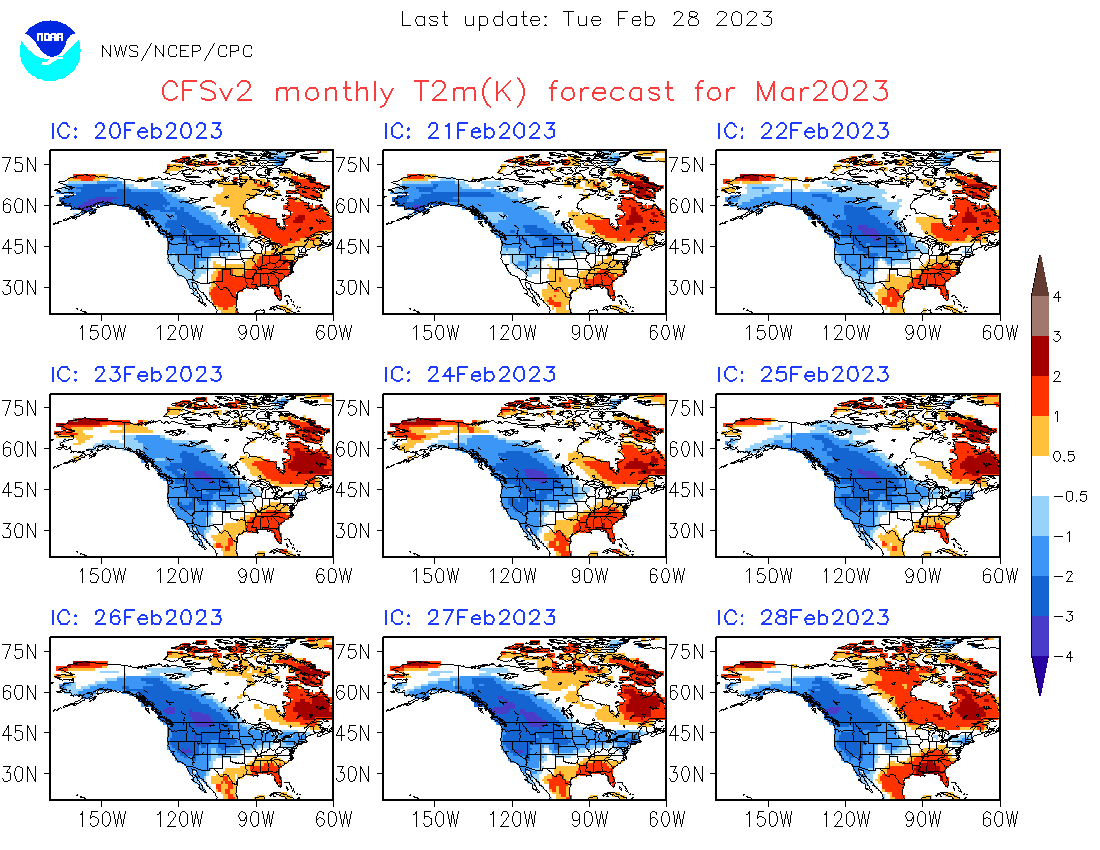
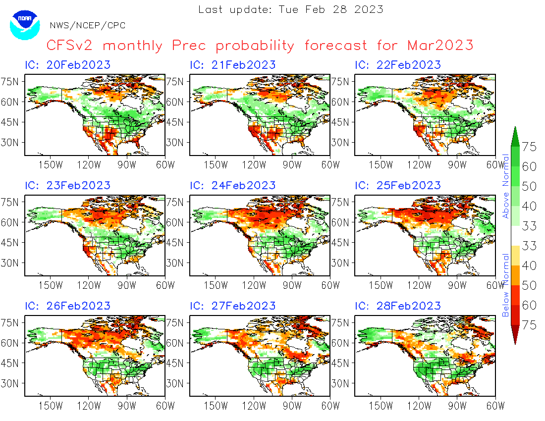
Mookie, check out that CPC today!!! It’s a thing of beauty! All I gotta say is WOW, just WOW!!!!
The long range guess looks mild and wet for this time of the year. It looks like there might be a long period of March type weather. There are some hints that March could be cooler than average so what we see now could be a long period of temperatures in the 40’s
Slim
And March could be wet as well. And there is always a chance of a snowstorm in March.
Slim
It seems summer, fall, and winter all all trending warmer and spring is stalling out. Which is a good thing for the crops and for keeping the tornadoes to our south, as Bill always says
Kiddo said I thought Phil said 6 weeks more of winter…it doesn’t feel very winter like. Lol!!
Love that sun though!!
Agreed. So much sunshine in the past week. It’s been great. We’ve lost probably just over half of our snow. More green than white on the ground.
Not saying it will happen but maybe just maybe March and the start of April will be cold?
Slim
It is beautiful outside this morning. It is so nice to have the sunshine. It doesn’t even feel cold out. Spring is on it’s way! 🙂
Heck yeah Sandy, spring is just around the corner and the forecasted warm temps will get everyone in the spring mood!
More hours of sunlight, higher sun angle, warm temps, melting snow. It must be spring soon!
Bright and clear skies again this morning. Seems that in 6 days of February already we’ve already had more sunlight than the past 2 months combined.
Wow! My heating bill was down -33% versus last year. Who wouldn’t love all these warm temps?
Warm temps for weeks on end coming up!! I love short winters!! The big MELT is happening with these bright sunny sky’s today!! Bring it!!
https://weather.com/weather/tenday/l/b523690bfd952b86fef3627c919dd9855281a8da16b83c10bdd381c64ae12cbc
Look at all that warmth! I love short winters!
If you like warm, sunny weather you will not
like the next several weeks!
Where is all your promised cold and snow in February? LOL
Wrong as usual. Sun was out today from sunrise till sunset, which looked incredible tonight with all the colors.
If you like winter and winter activities, you are not going to like the next several weeks.
Good morning! So far this year there have been 30 days with a above average mean and just 6 days with a below average mean. Yesterday was that 30th day above. With a H/L of 39/29 there was a trace of snow fall yesterday with the cold front but before that there was 29% of possible sunshine. We are now starting our slow climb of average temperatures and the average H/L is now at 32/18. The record high for today is 54 set in 1938 and the record low of -9 was set in 1895 and 1977. The record snow… Read more »
Best time of year to have so many above average days. Would not want to see July or August be 8 to 10 degrees above average the whole month!