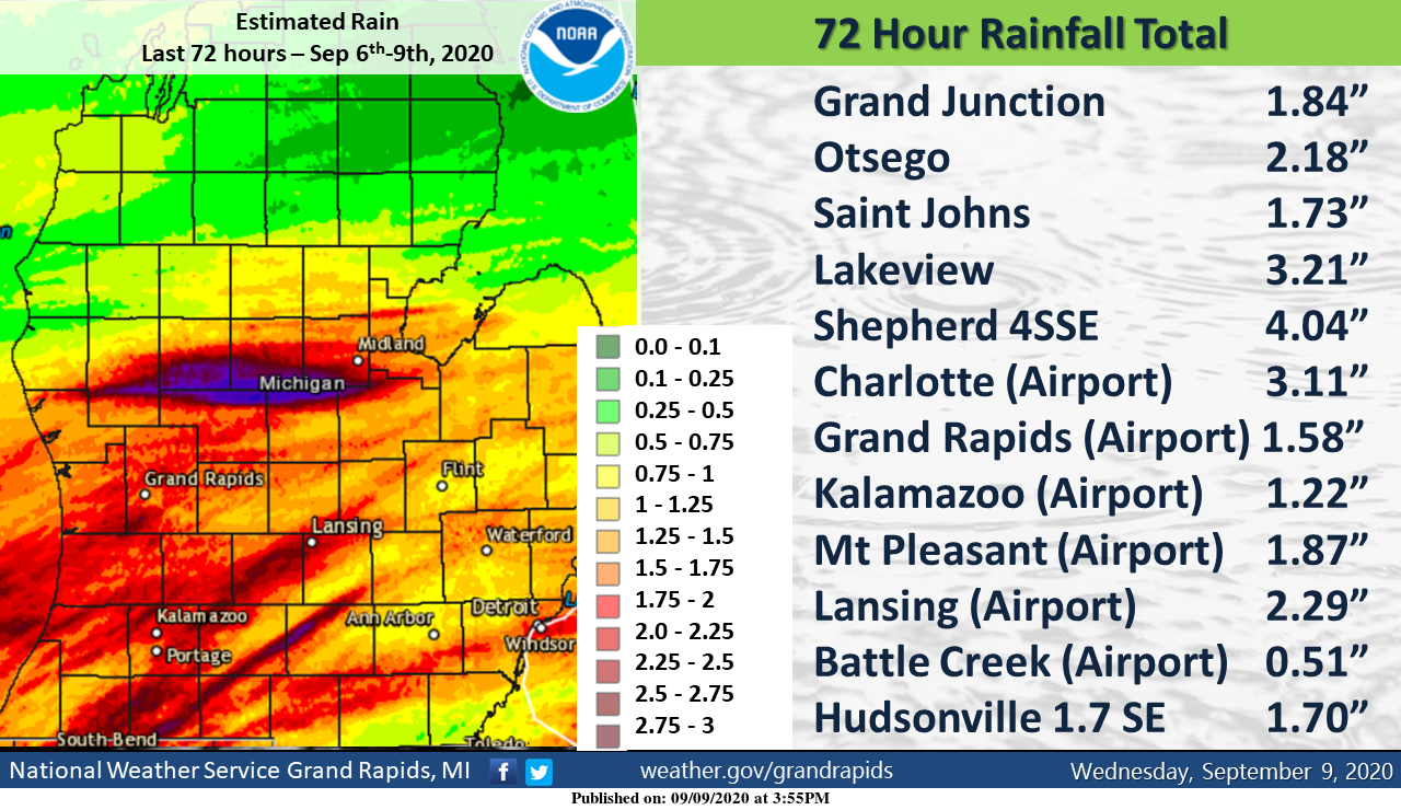
We barely broke 60° yesterday which held steady during the daylight hours with a trace of rain after 7 am. After all the sunny days we had this past summer it sure has turned dreary which is a reminder of things to come in the Great Lakes region. For the records, below are the 72-hour rainfall totals for the 6th through the 9th.
[columns] [span6]

SW
[/span6][span6]
SE
[/span6][/columns]
[columns] [span6]
North
[/span6][span6]
U.P.
[/span6][/columns]
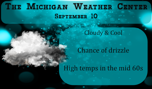
Today will once again be cloudy however we have hopes of the sun returning tomorrow.
Forecast Discussion:
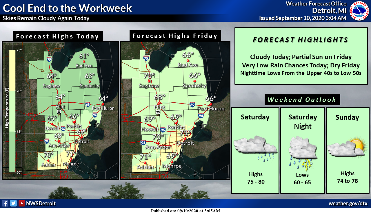
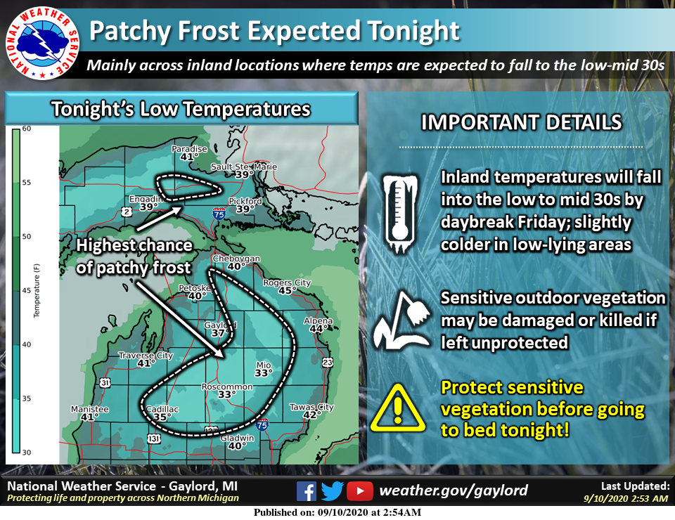
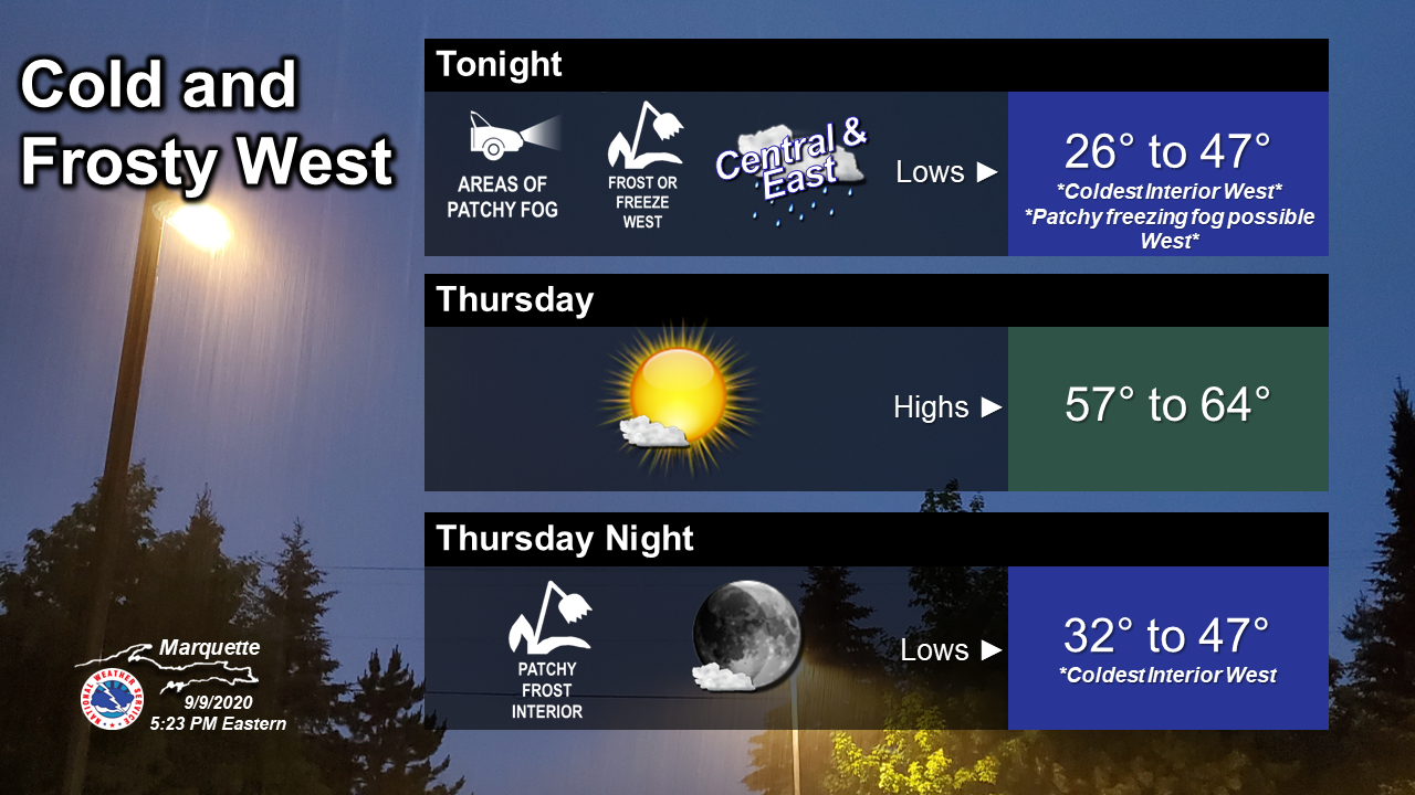
-- Drizzle early this morning, isolated showers possible today --

Drizzle and fog will continue early this morning, but it looks
like we should stay above Dense Fog Advisory criteria based on
high resolution model guidance. Some wind increasing in the lowest
couple thousand feet out of the north should keep the fog from
going widespread 1/4 mile or less. The lowest visibilities should
be seen along I-94 through 5am or 6am this morning around 1 mile
or so.

Cannot rule out a stray shower this morning, but high resolution
models are not bullish on precipitation. High pressure is nosing
in from the north and the surface boundary is well off to the
south so forcing for showers will be limited. We have isolated
shower wording in for this morning (20 pct).

-- Patchy frost potential along U.S. 10 tonight --

Model guidance suggests that the traditionally colder spots up in
across Central Lower Michigan (like Leota in Clare County) will
dip into the upper 30s tonight. Most locations will likely bottom
out around 40 however. The MOS guidance at Houghton Lake which I
like to use as a guide for our northern row is suggesting 36-38
degrees for a low. There is a bit of wind, around 10 knots, just
off the deck so not expecting lows to really bottom out tonight.
Bottom line, we may see some patchy frost along U.S. 10. Not frost
headlines look to be needed.

-- Showers and a few storms possible Saturday into Sunday --

An upper low seen in water vapor imagery tonight over the Four
Corners region of the desert southwest will move our direction
over the next 48 hours and transition into an open wave as its
absorbed into the westerlies. This will be the main weather maker
of the next 7 days with chances for precipitation from Saturday
afternoon through Sunday morning. The best chances for precip will
come Saturday night. The threat for thunderstorms looks to be
small, but cannot be ruled out. I-96 to the south probably stands
the best chances at some isolated thunderstorms but LI`s that
barely go negative and CAPE values less that 500 j/kg are not very
exciting. 60-80 pct pops are our highest Saturday evening/night.

-- Mainly dry early next week --

High pressure builds in behind this wave with northwest zonal flow
aloft. The period of Sunday afternoon through at least Tuesday
looks pretty quiet. A front will be in the vicinity on Wednesday
and we may have some showers then, but for now the forecast is
dry. Temperatures through the entire period will be close to
normals.
Grand Rapids now has had 3 days in a row of highs only in the low 60’s. The highs on Wednesday were the 2nd coldest maximums for the day at Grand Rapids, Muskegon, Holland and at Lansing it was the coldest maximum since 1943.
Slim
With this beautiful Fall weather we are enjoying are you ready for some football the NFL is back …INDY
Childish Banter on here is sickening,
WOW well join the fun ..A blog with no cues and political views allowed lol….INDY
Nice Try…..Childish ONE
There are hints of weak to moderate La Nina for the upcoming winter season. Some recent weak La Nina winters are 2017/18. 2016/17. 2008/09. 2005/06. 2000/01. And some recent moderate ones 2011/12. 1995/96 1970/71. That would be a good start for this winters analogs if you are inclined to want a winter long range guess.
Slim
Don’t believe in analog years, sorry
Lol unless it’s about warm weather ..INDY
Yes Slim lots of talk out there about Winter starting early in the Midwest that would mean more snow for the great lakes shuuu quick fact for mid September already 6.7% of the United States has snow cover on the ground amazing …INDY
Looks like plenty of pleasant 70/80’s upcoming. Guess I’ll keep the pool open for a few more weeks!
Such a spin ….80’s and mid 90’s this week!!! …with 40’s and 50’s at night you do that keep your pool open!! Lol …iNDY
Mookie is on tilt! He is delusional, but that is nothing new!
Just heard Muskegon had its warmest summer on record! Wow!
Muskegon just had there coldest September day for the 9th great Scotty….INDY
Fired up the snowblower she turned right over shes ready to blow …The rakes and snow shovels are out pool is closed up fire wood is staked it’s beginning to look like FALL around here heck it already feels like FALL that’s for sure what a work out yesterday never even broke a sweat lol……Have a great Thursday INDY ….
Before I bought my current snownblower I had a Craftsman that one would start great in the fall. But as soon as it got cold with snow that thing would not start. I used to have to bring the thing into the house and let it warm up before it would start. And that was from when it was new. I took it to Sears several times when it was still under warranty and they claimed there was nothing wrong with it. Well I sold it during one of my wife’s yard sales.
Slim
Yesterdays official high of 60 at Grand Rapids was the 2nd coldest maximum of any September 9th in Grand Rapids recorded history. I recorded 0.02″ of rain yesterday. At this time it is cloudy and 53 here.
Slim
So much for the 80’s and mid 90’s that was once predicted this week by the turn up the heat guys ..lol..only made it to 58* degrees yesterday out at thee YARDofBRICKS NE of GR so that’s a record in my book …love it INDY
Thanks for the cold facts! We are in an amazing cool stretch! Let’s keep it rocking!