
Todays Forecast
U.S.A and Global Events for September 28th:
1837: The first recorded storm to rake the entire Texas coast was Racer’s Storm, named for a British sloop of war that encountered the system in the extreme northwestern Caribbean on September 28th. It is remembered as one of the most destructive storms of the nineteenth century due to its extreme duration and 2000-mile path of destruction.
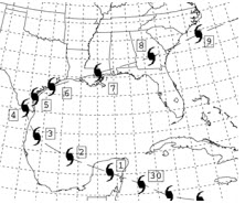
The image above is courtesy of the Weather Prediction Center. The numbers next to the hurricane symbols are dates.
1874: A strong category 1 hurricane went by Charleston and Georgetown, South Carolina. The tide was at an unprecedented height, inundating the entire riverfront of the city of Charleston. Click HERE for a tweet by Cary Mock, a professor at the University of South Carolina.
1929: A hurricane-spawned tornado hit Fort Lauderdale, Florida. While the path length of this estimated F2 tornado was 0.8 miles, it caused 16 injuries. Click HERE for a tweet from Tornado Talk.
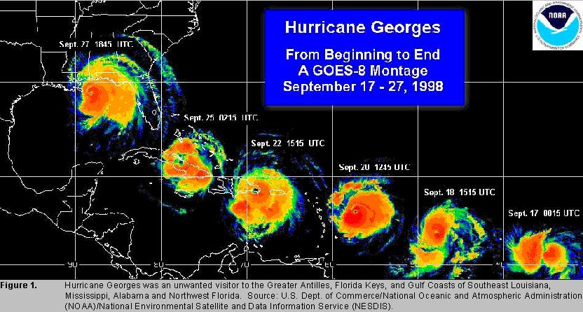
1998: On the morning of September 28th, Hurricane George made landfall near Biloxi, Mississippi with maximum winds of 110 mph and a minimum pressure of 964 mb, making it a Category 2 hurricane. After landfall, Georges moved very slowly across southern Mississippi and weakened to a tropical depression by the morning of the 29th when the center was about 30 miles north-northeast of Mobile, Alabama. The storm dissipated near the northeast Florida/southeast Georgia coast by the morning of October 1, 1998. Click HERE for more information from the National Weather Service Office in Mobile.
Forecast Discussion
- Continued precipitation chances today -

Agree with previous thinking that our thunder threat is too small
to mention. GOES upper tropospheric IR/water vapor channel (CH08)
nicely shows a PV maximum that had rotated northwestward,
resulting in an associated westward-northwestward extension of
precipitation coverage to the US-131 corridor. Here at the Grand
Rapids airport, we received our first measurable precipitation of
the day (0.01 inch) between 1 AM and 2 AM. Precipitation over the
Grand Rapids vicinity is slowly dissipating beneath warming IR
cloud tops. Precipitation farther east towards US-127 is more
persistent where we see deformation flow aloft and an area of weak
conditional instability aloft as suggested by slightly negative
EPV in the SPC mesoanalysis graphics.

As tempting as it is to shunt precipitation chances to the south
and east of Grand Rapids, there are multiple Convection Allowing
Model (CAM) solutions indicating we could still get a shower or
two in the afternoon, so have adjusted PoPs accordingly. Rain
chances will be slowest to decrease today over our southeastern
forecast area, which includes Jackson.

- Risk for fog tonight and Friday morning -

After this, attention turns to fog potential Thursday night and
Friday morning. As noted in the Aviation section of this
discussion, we expect a mix of low clouds and fog, especially
south of I-96. If we lose low clouds, that will be favorable for
radiation fog; however, we may also maintain a low stratus deck
overnight; this would be less favorable for fog and more favorable
for the Friday morning commute.

- Warming trend into early next week, getting drier -

A mid to upper level ridge strengthens as is builds in from the west
over the weekend.  Low level winds become southwesterly during this
time and stay that way into the middle of next week.  This is a warm
air advection pattern which will result in steadily rising
temperatures.  There is really not a lot of spread in the
temperatures from the ensemble forecasts even into the early next
week.  The GFS has trended a little lower from its very high values
next week and is now closer to the other models.  Basically it looks
like many areas will make a run at 80 degrees with some potential to
go a degree or two higher. The warmest days will likely be Tuesday
or Wednesday, this is ahead of an approaching mid to upper level
wave.  Little or no Gulf moisture advects in ahead of this feature.
As a result, while daytime temperatures rise each day, the afternoon
humidity levels will likely lower.  Combine that with gusty
afternoon winds ahead of the approaching front and we may end up
with an increased fire danger risk by Tuesday or Wednesday.

- Small chance for showers Wednesday -

The mid to upper level low that will be over the Southwest U.S.
through the weekend is shown by the models to open up and lift up
into the Upper Plains or Great Lakes region by mid week.  At this
time, little or no Gulf moisture advects into MI. As a result, only
a limited potential for showers exists as this feature tracks
through for the middle of next week. Most ensemble members from the
various models are dry for the middle of next week, which supports
only a low risk for measurable precipitation.
So September will end up with above normal temps!! How is that possible with all the cold weather hype and propaganda on here??
It’s been a warm stretch and the real warmth hasn’t even begun!
Oh yeah! Temps in the 70’s and 80’s for over a week straight, IN OCTOBER, More like the end of JUNE!!
Who wouldn’t love that weather this time of year??
The weather here in Colorado has been just amazing. Incredibly dry air, 70 degrees every day, and there hasn’t been a single cloud in the sky since we arrived last Saturday. The Aspens in the mountains are at peak color, I don’t think we could have timed our trip any better. Not looking forward to coming back to the thick humid air of Michigan.
Looking forward to heading to Art Prize this weekend. Looks like great weather and probably some big crowds… hopefully Bill stops by, haven’t seen him since before covid actually
Guess what? It is another cloudy, cool day today! Incredible!
Three consecutive dreary days of clouds and off and on showers. The low has only moved like 200 miles in the past three days.
Guess what? It was another above normal temp day! Over a week straight! Wow, just wow, WOW!!!
The start of October still looks to be on the very warm side. With a good amount of sun highs look to be in the upper 70’s to low 80’s and lows in the mid 50’s to near 60. This is well above average. My wife and I are going to the Tigers game on Saturday. As we all know this weekend will be the last games for Miguel Cabrera. Of course, this is a day game and unfortunately there is no shade at Comerica Park. So with highs in the 70’s with a lot of sun it will be… Read more »
Will 0 sunshine yesterday was a rather cool day with the official H/L at Grand Rapids of 64/58. There was a trace of rain fall, 4 HDD’s the highest wind speed was 21 MPH out of the E. Overnight I recorded 0.02” of rain fall that is the 1st rain fall for this week. For today the average H/L is now down to 69/48. The record high of 86 was set in 1905 and the record low of 27 was set in 1991. The record rain fall amount of 1.96” fell in 1999. Last year the H/L was 54/47 and… Read more »