The advisories will finally end at 10:00 am this morning and snow will diminish along the lakeshore. We have 10° at 4:30 this morning and another inch of lake effect snow to add to our total giving us 17.9 inches for the month and 31 inches for the season. Last year at this time we had 15.2 inches and 23 inches the year before that. We had a high of 22° and a low of 13°.
Today will be cold once again with temps in the teens. Lake effect will diminish as the winds begin to flow more out of the south/southwest and the clouds may part to give us some opportunities to see some sun today.
Today is the anniversary of the Cleavland Superbomb as shown below in the weather history. I was 22 at the time and we moved about on snowmobiles after the storm, even then it was iffy at best. We had to crawl over ten-foot or better snowbanks twice a day to get to our horse barn half a mile down the road to take care of the horses. This is something I wouldn’t care to do today for sure it was hazardous but it had to be done. Having lived in the mountains of Maine in the early 70s I was used to bitter cold and noreasters so I could handle this back then.
Weather History for SW Michigan
January 23
1909: Lower Michigan is in the midst of a three-day stretch of warm weather. Lansing hits a record high of 60 degrees. Grand Rapids reaches 56 degrees, also a record.
1948: Record lows on this date include 19 below zero at Grand Rapids and 13 below at Muskegon as arctic high pressure and deep snow cover have Lower Michigan in the deep freeze.
January 24
1967: A huge storm is gathering over the Plains States. Out ahead of it, strong southerly breezes bring record warmth to Lower Michigan. Lansing soars to 66 degrees, the warmest on record for the month of January.
January 25
1950: Muskegon sets the record high for the month of January at 63 degrees. Grand Rapids also ties their monthly record high of 66 degrees.
1967: Temperatures reach the 60s for the second day in a row across Lower Michigan. However, the spring-like weather is about to give way to one of the greatest snowstorms on record.
January 26
1967: Temperatures in the 20s are some 40 degrees colder than the day before, and heavy snow begins falling, piling up a foot or more along with increasing winds.
1978: A storm known as the Cleveland Superbomb moves north from the Gulf of Mexico and deepens explosively, becoming one of the worst blizzards in Midwest history. From one to two feet of snow falls across southern Lower Michigan, whipped into huge drifts by strong gusty winds. Several new records were set including a new record low sea-level barometric pressure of 28.68, observed at 6:00 AM. At least 9 deaths were attributed to the blizzard, most roads were impassable, roofs collapsed under the weight of the snow and the airport in Grand Rapids was closed from late on the 25th until the 27th. Governor Milliken declared a state of emergency and requested additional federal aid for snow removal.
January 27
1967: Chicago’s greatest snowstorm on record also extends into Lower Michigan, where Battle Creek records 28.6 inches of snow. The storm total at Lansing is 23 inches and 18 inches at Grand Rapids.
1994: A snow and ice storm brings travel to a halt across Lower Michigan. Freezing rain causes widespread power outages and results in 5 million dollars damage.
January 28
1977: Buffalo, New York is hit with the worst blizzard in its history. Meanwhile, lake effect snow squalls also pummel areas in western Lower Michigan with more than a foot of fresh snow being piled into huge drifts by strong winds.
January 29
1909: A snowstorm dumps from 6 to 10 inches of snow across southern Lower Michigan.
1966: A week-long cold snap reaches its nadir as temperatures fall to record lows of 16 below zero at Grand Rapids and 12 below at Muskegon.
Weather History for SE History
January 23
On January 23, 2019, a mix of snow, sleet, and freezing rain was coming to an end across the region. The Thumb saw snow of around 4 inches, while areas to the south saw a coating of ice due to freezing rain/sleet. After the precip moved out, temperatures rose to around 40 degrees through the rest of the day.
On January 23, 1909, a two-day trend brought record high temperatures of 59 degrees on the 23rd and 58 degrees on the 24th in the city of Saginaw.
January 24
On January 24, 1963, Detroit had a high temperature of 4 degrees and a low temperature of -13 degrees, which equates to a very cold day!
January 25
On January 25, 1950, the daytime temperature soared to 67 degrees in Detroit. The normal high temperature for January 25 is only 31 degrees!
Also on this date in 2007, an intense lake effect snow band hit the thumb, leaving the Lake Huron shoreline areas with 10 to 12 inches of snow.
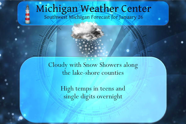
January 26
On January 26, 2021, a low-pressure system brought widespread snow to the region with 3 to 5 inches observed north of I-69. Much of this occurred during the morning commute with visibilities dropping to around a quarter-mile and snow quickly accumulating on the roads.
On January 26, 1978, a blizzard hit southeast Michigan. This caused the lowest all-time pressure to be recorded in Detroit: 28.34 inches!.
January 27
On January 27, 1967, a blizzard hit the Saginaw Valley, Thumb and Flint areas. By the time the snow ended, 23.8 inches of snow had piled up in Saginaw, and Flint was buried under 22.7 inches of snow! This storm was the biggest snowfall in Flint and Saginaw history.
On January 27, 2002, the daytime temperature rose to 56 degrees in Flint, setting the record high for this day. Curiously enough, the very next year on this day (January 27, 2003), the temperature fell to -11 degrees, setting the record low for the day.
January 28
On January 28, 2019, a winter storm impacted the area with the Thumb and Tri-Cities region receiving 7 to 10 inches of snow. The system ushered in the coldest air of the season in its wake with dangerous wind chills occurring for a couple of days following.
On January 28, 1906, Saginaw had a record high temperature of 47 degrees. For all the record highs recorded in the month of January, this temperature was the lowest. All other record high temperatures for the month varied between 50 and 62 degrees.
January 29
On January 29, 2018, widespread accumulating snow fell over Southeast Michigan. Most locations saw 1-5″, but a very narrow band of heavy snow developed along a line from Perry to Durand to Flint. Ten inches of snow was observed at Flint, making it it the 16th largest snow in its climate record.
On January 29, 1947, 1.32 inches of rain fell in Flint!
Forecast Discussion
-Lake effect snow and cold air today

The lake effect snow showers that have been covering the lakeshore
over the last few days is finally nearing its end. Latest
satellite shows a line of snow showers diminishing and weakening
from the northeast to southwest as dry cold air infiltrates into
lower Michigan and the upper level support for the lake effect
snow moves eastward. High pressure is building in that coupled
with the cold air will stifle and end any lake effect snow this
morning. Some bands of snow could linger near Holland through mid
morning but accumulations will only but upwards of another inch or
2 in most locations. In areas not experiencing snowfall the cold
air will move over the region and expect the clearing skies to
only drop the temperatures that much more. Minimum temperatures
this morning will range from the negative single digits around
Clare to the single digits near Kalamazoo. The winds will be calm
to very light but any wind will make wind chills of -5 to -13. So
it will be near advisory criteria. Temperatures will today will
rise only to the upper teens.

-Light Snow Thursday and cold into the weekend.

The next weather is another clipper that will swing through the
region Thursday. This is yet another trough rotating around the
quasi stationary upper level low that continues to sit near Hudson
Bay. That low will continue to dominate the weather pattern
through the near future. The models are in fair agreement on the
timing and strength of this wave, as well as its lack of moisture.
It could still put a widespread 1 to 2 inches across Michigan but
will move quickly and be gone by Thursday night. Another shot of
bitterly cold air is in store Saturday morning with temperatures
in the low single digits to below zero as a positively tilted
ridge builds over the region and brings clearing skies and calm
winds to the area. Temps will warm to upper 20s by Sunday.
Check this out? Incredible!
https://www.pivotalweather.com/model.php?p=snku_acc&fh=384
Great Scotty 👍…InDy
-6 here this morning. Spoke to a friend in the South Bend area and their schools closed today. Too cold for the kids to be standing at the bus stop.
Wow, that 6-10 CPC outlook is a thing of beauty! Can you say MELT?
Just another day of a winter with below average snow. I love it!
Lol…InDY
Lol
Actually I agree, both the 6-10 and 8-14 day Cpc show near to below normal temps and above normal SNOW! Now that is a thing of beauty! Thanks for bringing this to my attention! Rock on Winter?
Yesterday there was some discussion as to the coldest period now have come later in the winter. Well I took a look to see how the warmest days in summer compared to the past at Grand Rapids. The warmest days in the 1981/2010 period the average warmest mean was 72.7 between July 10th to the 20th. In the 30 year mean in the 1991/2020 period rose to 73.0 and the dates were between July 11th and the 20th (not much change there) but in the newest 15 year period 2006/2020 the mean was up to 74.0 and the dates were… Read more »
The official overnight low at Grand Rapids was -2. Here at my house the low was -1 so far that is the coldest it has been this winter season. At this time with cloudy skies it now has warmed up to +5 here. There is now 6.5″ of snow on the ground here.
Slim
0″ degrees outside shivering snowmans…Im thinking about more ice fishing today…Lets keep this Winter rocking….InDY
>>>Breaking News>>>there is something brewing in the long range towards the end of next week! Possible major snowstorm for MI! Mark it down and you heard it here first! Incredible!
I was just looking at that it definitely could be something big …BABBY HOLD ONN!! InDY
Local TV met just talked about this. He said right now, it looks pretty good for a decent system coming through next Thursday-ish.
Who would have thought?
Amazing stretch of cold weather! What a winter! Rock n roll will never die!