
Yesterday we had occasional light showers with a high of 68°. Today will be similar to yesterday with showers and warm temperatures in the upper 60s for SW Michigan. Warm south winds will result in above-normal temperatures through the end of the week. Occasional showers and thunderstorms are possible too. Much colder air will arrive by the end of the weekend and some snow may mix with the rain showers early next week. We are entering leaf-clogged storm drain season! When traveling, be aware of ponding around storm drains that may be clogged with leaves. Most of the leaves have changed and are quickly falling off the trees. I mulch the leaves with my lawn tractor any that are left I blow into piles and haul them off to the woods with the trailer. Next week the mower deck comes off and the snow blade and chains go on ready for the winter season.
Forecast
U.S.A and Global Events for October 26th:
1865: A hurricane sank the steamship USS Mobile off the Georgia coast. The wreck, laden with 20,000 gold coins, was found in 2003.
1952: There have been thousands of weather reconnaissance and research flights into hurricanes in the Atlantic and Pacific since the mid-1940s. There have been several close calls, but only four flights have been lost. A B-29 Super-fortress flight into Super Typhoon Wilma 350 miles east of Leyte in the Philippines disappeared on this date. No trace was ever found of the plane or crew. In the last report, the flight was in the Super typhoon’s strongest winds, which were around 160 mph.

1997: An autumn snowstorm pummeled central and south-central Nebraska with record early-season snows. Wind-driven snowfall amounts totaled as much as two feet by storm’s end. Several highways were closed, including Interstate 80, as near-blizzard conditions developed. Once the snow subsided, the record early-season snow totals were tallied. Guide Rock measured twenty-four inches of snow, Clay Center twenty-three inches, and Hastings seventeen inches. A fifty-mile wide swath of snow more than fifteen inches fell from near Alma to York. Amounts further north averaged from four to eight inches. The heavy, wet snow was responsible for many power outages in the area as tree limbs broke and fell on power lines. At one point, the town of Hardy had no power and could not be accessed by vehicles due to the snow. Numerous schools and businesses remained closed for several days following the storm. Many highways, including Interstate 80, closed at the height of the storm. On Highway 136 east of Alma, road crews worked for ten hours carving through a ten-foot drift that covered the road. Record cold accompanied the snow as temperatures dropped to the single digits on the morning of the 26th.
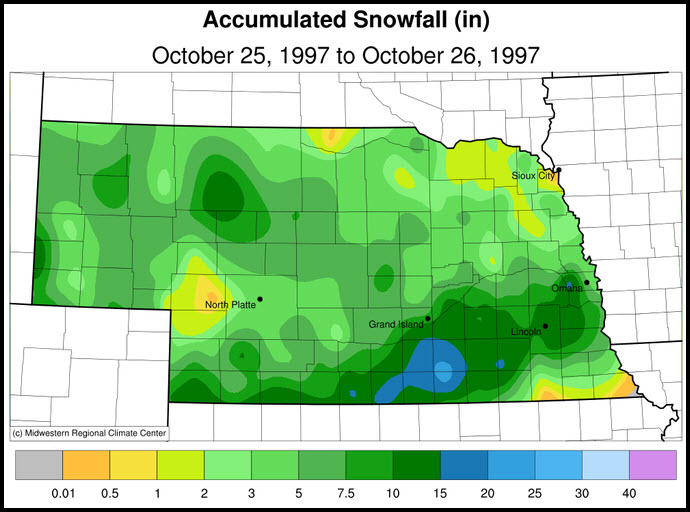
The snowfall map above is courtesy of the Midwestern Regional Climate Center.
1998: Hurricane Mitch, the second deadliest hurricane in the Atlantic Ocean, reached Category 5 strength on this day.

The image above is courtesy of NOAA.
Forecast Discussion
A band of precipitation currently extends from the Grand Haven area
eastward to the thumb of Lower Michigan. This is associated with a
warm front that will lift north towards US-10 later this morning.
North of the front we see widespread fog as one would expect north
of a warm front. This area of fog will similarly be pushed northward
later this morning. There could be a brief period of dry conditions
and perhaps even clearing mainly south of I-96 later this morning
and into afternoon before another area of precipitation, currently
moving northeast towards Chicago, overspreads southwest Lower MI.
Precipitation coverage should be most extensive from this
afternoon into early tonight.

The final round of precipitation, associated with a seasonably
strong cold front, will traverse the area Friday afternoon and exit
by early Friday night. Diurnally bolstered conditional instability
ahead of the front will be supportive of thunderstorms, hence the
SPC Day 3 general thunder outlook for Lower Michigan. Forecast
soundings indicate strong unidirectional southwesterly flow in the
lower troposphere with a suggestion of incipient dry slotting. This
could end up as a cold frontal rainband with marginally severe wind
gusts thanks to downward momentum flux associated with moderately
large values of ML Downdraft CAPE (DCAPE). Would not be surprised to
see a Marginal SPC Outlook for our area down the road.

As noted before, rainfall totals will be below levels that will
cause any issues.

- Rain moving back in for Saturday night

The high pressure ridge builds east of the region during the day on
Saturday as a mid level trough approaches from the west. Aloft the
right entrance region of a strengthening jet will be situated over
MI. The DGZ moistens up overnight which will support high POPs for
the area. Northern zones should see the least qpf given the
northerly low level flow advecting in some drier air into that
region. Southern zones are progged to see stronger 850 mb
convergence which will support higher qpf values in that area,
including the Kalamazoo River basin.  The deeper moisture pulls away
later Sunday into Sunday night and the DGZ becomes unsaturated.
This will support a diminishing trend to the POPs.  From an ensemble
perspective, there is still a lot of spread in the qpf values so
there is still a decent amount of uncertainty on the amount an
duration of the precipitation.

- Lake effect clouds and precipitation early next week

Colder air steadily advects in for Monday and conditions become
favorable for lake effect clouds and precipitation. Tuesday is when
some of the models are showing a mid level vort max digging in.
This may combine with the ongoing lake effect to generate a period
of steadier precipitation.  As for the type, we could see some snow.
Forecast soundings from the GFS for Tuesday morning show surface
temps above freezing but the freezing level is low and the inversion
height up over 10k ft with a nw flow.  That is good enough for snow
and we will maintain this in the forecast.  May need to monitor the
Tuesday morning commute for the colder locations in out northern CWA
for possible slick spots on bridges and overpasses. Ensemble
snowfall values also suggest the northern zones will need to be
monitor for possible impacts.
Get ready for the big cold front! Incredible!
Prayers for the people in the Lewiston/Auburn Maine area – this is a college town not far from where I used to live. Many dead many more injure in the mass shooting.
Our cold wet cloudy Fall continues looks like snow showers next week across west Michigan Winter is approaching fast and its not even Halloween yet!! Crazy… INDY
Wow, crazy cold and snow is coming! The overall cool pattern is still locked in! Incredible! Winter could be wild!
Wow – we just had a low temperature that was 2 degrees warmer than the average high temperature!
What? More rain and then another big COLD front! Who would have thought? Rock n roll baby?
We typically see our first flakes around Halloween. Looks right on track this year. Also like you mentioned, the leaves are really starting to change/fall now
The official H/L yesterday was 68/58. It was a kind of upside down day with he high coming just after midnight and the low coming at 2:26 PM. There was 0.33” of rain fall and no sunshine. The highest wind gust was 23MPH out of the SW. For today the average H/L is now down to 56/39 the record high of 79 was set in 1939 and the record low of 24 was set in 1962 and 1990. The record rain fall amount of 1.11” fell in 2019 the record snow fall of 2.0” fell in 1925. Last year the… Read more »