
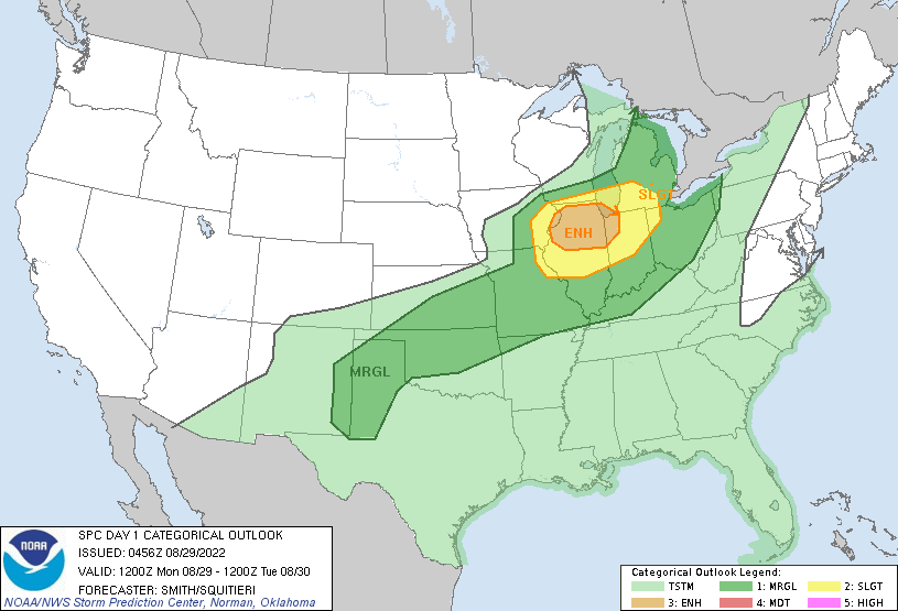
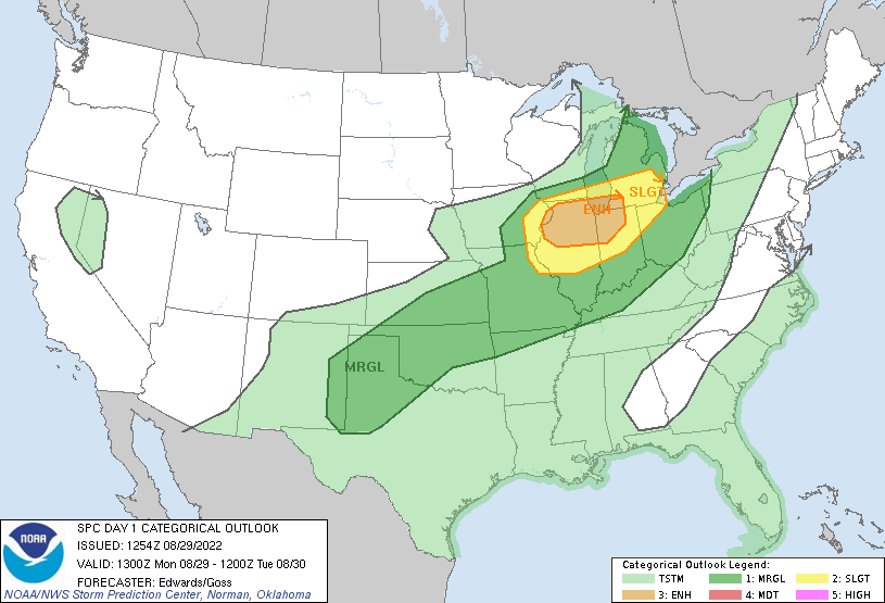
We got through yesterday and overnight without a drop of rain in Otsego. Northern Allegan County and Ottawa County had a severe thunderstorm warning between 9 and 10 last night. Today will be a hot and humid day with temps in the mid to upper 80s with high dewpoints with chances of rain and severe storms later this afternoon. We have a level two (slight) risk for storms from Grand Rapids to the south with a level three risk (enhanced) in northern Illinois nosing into northwestern Indiana.
We have a muggy 71° at 6 am this morning. Yesterday’s high was 86° and the low 59.5°.
Forecast Discussion
A good chunk of today is probably going to be dry. Latest radar
imagery shows showers exiting the cwa to the east but not before
they dumped over 2 inches of rain in several locations. We`ll see
more rain late this afternoon, especially south of I-96 and some of
the rain could be locally heavy.

Severe storms aren`t out of the question this afternoon. We have a
very moist airmass in place and lots of dynamics in play today.

A developing upper trough over the northern Plains will move east
and push a cold front across Wisconsin this afternoon. Expect
showers/storms to develop in advance of these features after 21z.
Mid level lapse rates are also progd to increase to 7.5C/km during
the late afternoon. The right entrance region of the upper jet also
moves in during this time. Finally, bulk shear increases to 45 knots
prior to 00z over the southwest cwa. These features could certainly
lead to a few strong to severe storms from late afternoon through
early evening. In addition to strong winds torrential rainfall
leading to ponding is likely.

The precipitation will end overnight as the cold front moves
through. Clearing will occur Tuesday behind the upper trough axis
and then we`re looking at dry weather for the rest of the week.

Highs in the 70s and dewpoints in the 50s are expected Tuesday
through Thursday before temperatures warm into the 80s Friday. A
return to humid conditions is expected by Saturday when south flow
strengthens again ahead of the next cold front.
The 2022 severe weather season has been rockin and rollin in my area. Most active and damaging since 2015. Is it just me or does it seem the more active severe days have been July and August recently and not so much in June?
As a side note I picked up 0.80” of rain today. Very very wet August.
Lost power again lots of damage around my area. The debris field runs from west Otsego south to Alamo. I have lots of pictures. I can’t help but wonder if a ef0 went through. Hopefully we get the power back tomorrow.
Yikes sounds bad. I haven’t driven around my area but we did clean up a large white pine limb that came down in the first big gust of wind. There lots of tree and power line damage area wide. Drive safe if traveling the side streets and rural roads especially everyone!
The rain has ended here and at MBY I recorded a total of 0.84” of rain in todays rain events. The storm that formed almost overhead had the most rain with 0.55 in about 20 minutes that caused some road flooding and there was some close by lightning strikes. In the next storm there was some wind with heavy rain but no where near as heavy as earlier. In total there has been 1.92” of rain fall between the overnight rain and the rain this afternoon. At the current time there is just under 160,000 locations without power at Consumers… Read more »
28% of consumers customers in Jackson County have no power and 33% in Calhoun. Those are very high numbers.
120K+ Consumers customers without power.
Storm just blew threw here. Very little lightning or thunder but definitely gusty. I would not put it at severe criteria but we did loose a large white pine limb
Just blew through here too…literally. It’s difficult to estimate the wind speed, but it’s been quite some time since I’ve seen the trees bend like that. There is tree debris all over the golf course. Local TV met just said 51 mph gust at their station in Lansing. 55 mph gust in Saint Johns.
And now it is pouring rain – similar to the rain we received this morning.
The rain has now let up here. The big line of storms was not as bad as the pre storms that rolled thru here before. The main line had heavy rain but not as heavy and the first wave. There was some wind with the main event but not too much and just a little lightning (there was a couple of close strikes with the first storm) I just took a rain fall measurement while the 1st storm dropped 0.55″ in less than 20 minutes the 2nd one only added 0.23″ for a total of 0.78″ but that is added… Read more »
ADA – well…just heavy rain. Dark and noisy to our North. Routine. On the bright side?…sprinklers OFF.
6/10 of an inch from today’s line.
Newest warning goes all the way to Lansing. They are blanket warning this line.
The storm before the storm was much worse here.
Slim
Observed wind gusts. At 3:08 pm, the West Michigan
Regional Airport in Holland had a gust to 66 mph.
58 mph wind gusts at the airport in GR and Battle Creek.
So far have had 0.55″ of rain in a very short time. Streets are flooded and there is more rain on the way.
Slim
* Severe Thunderstorm Warning for…
Northwestern Allegan County in southwestern Michigan…
Ottawa County in southwestern Michigan…
* Until 400 PM EDT.
* At 256 PM EDT, a severe thunderstorm was located near Holland SP,
or 8 miles west of Holland, moving east at 55 mph.
HAZARD…70 mph wind gusts and quarter size hail.
Velocities showing 65-75mph about to hit Holland SP. Of course that is just above the surface but some of that could make it to the surface
Severe Thunderstorm Watch for everyone until 8pm
SEVERE THUNDERSTORM WATCH OUTLINE UPDATE FOR WS 528 NWS STORM PREDICTION CENTER NORMAN OK 235 PM EDT MON AUG 29 2022 SEVERE THUNDERSTORM WATCH 528 IS IN EFFECT UNTIL 800 PM EDT FOR THE FOLLOWING LOCATIONS MIC005-015-021-023-025-027-035-037-045-057-059-065-067-073-075- 077-081-107-117-121-123-133-139-149-159-300000- /O.NEW.KWNS.SV.A.0528.220829T1835Z-220830T0000Z/ MI . MICHIGAN COUNTIES INCLUDED ARE ALLEGAN BARRY BERRIEN BRANCH CALHOUN CASS CLARE CLINTON EATON GRATIOT HILLSDALE INGHAM IONIA ISABELLA JACKSON KALAMAZOO KENT MECOSTA MONTCALM MUSKEGON NEWAYGO OSCEOLA OTTAWA ST. JOSEPH VAN BUREN
80 with the sun peaking out at my house. Dew point of 72. It’s definitely soupy outside.
ADA – Gauges holding 1/2 of rainfall. Far too overcast for any “weather” today?…sadly so.
So much for no weather today?
SPC Discussion Update: …THERE IS AN ENHANCED RISK OF SEVERE THUNDERSTORMS FROM THE MISSISSIPPI RIVER ALONG THE ILLINOIS/IOWA BORDER ACROSS NORTHERN ILLINOIS TO NORTHWESTERN INDIANA AND SOUTHWESTERN LOWER MICHIGAN… …SUMMARY… Severe thunderstorm winds are expected today across parts of the middle Mississippi Valley into the southern Lake Michigan region. …Synopsis… The mid/upper-level pattern this period will be characterized by an expanding trough — embedded in otherwise zonal flow — and initially located from a low over southeastern MB to northern NE. By 00Z, this trough will move eastward to northwestern ON, western Lake Superior, western IA, and northwestern MO. Meanwhile,… Read more »
NWS Radar Forecast:

Updated SPC Forecast
We got home from the west suburbs of Chicago last night. Moved our daughter into college. Gotta love the freshman dorms – no A/C and she’s on the 3rd floor. It was a hot and humid 92 yesterday.
Remember the days when home air conditioning wasn’t commonplace? When I was growing up in the 1960s we survived without it. No Walmart or Meijers to run to back then to get one, even if you could afford it.
I told her to look on the bright side – being on the 3rd floor, she will have no worries about being cold this winter. 🙂
This has certainly been a rainy summer. Looks like we have a lot of dry days approaching with comfortable temps… the best time of the year for “nice” weather is approaching IMO- September to mid October
Yesterday was a warm late summer day with a H/L at Grand Rapids of 86/59. Before midnight there was a total of 0.97” of rain fall and that will be the new 5th most for any August 28th during the day there was 57% of possible sunshine. Here in MBY I had a total of 1.08” of rain fall up to 7AM this morning. The official overnight low at GRR was a warm 71 the low here in MBY was 69 and that is the current temperature. After a warm and somewhat humid day today it will turn cooler for… Read more »
Total rainfall = 2.9 inches! Incredible!