
You don’t expect to see 75 or even 80-degree water in the Great Lakes in July or, in most years, anytime. But an exceptionally hot weather pattern pushed water temperatures in most of the lakes to the highest levels on records in the summer. Lakes Erie and Ontario, the water is the warmest it has been since the records began.
Surface water temperatures averaged over all of the Great Lakes, except the deep and choppy Lake Superior had risen well into the 70s to 80 degrees. That’s about the same water temperature as the surf off Virginia Beach, Va. Now due to upwelling, the surface temps have crashed.
The configuration of the wind over the course of the next day or so (Monday into Tuesday) will result in a plunge in water temperatures at the shore. Water temperatures have already cooled to the 50s and 60s as of Monday morning in many places. 50s water temperatures will become more common into Tuesday with 40s possible as well. The 70s water temperatures have pushed offshore towards mid-lake. It may take until this upcoming weekend to see an appreciable warm-up in water temps. Cold water shock can lead to drowning, so be aware of the situation if you are jumping into deeper water.

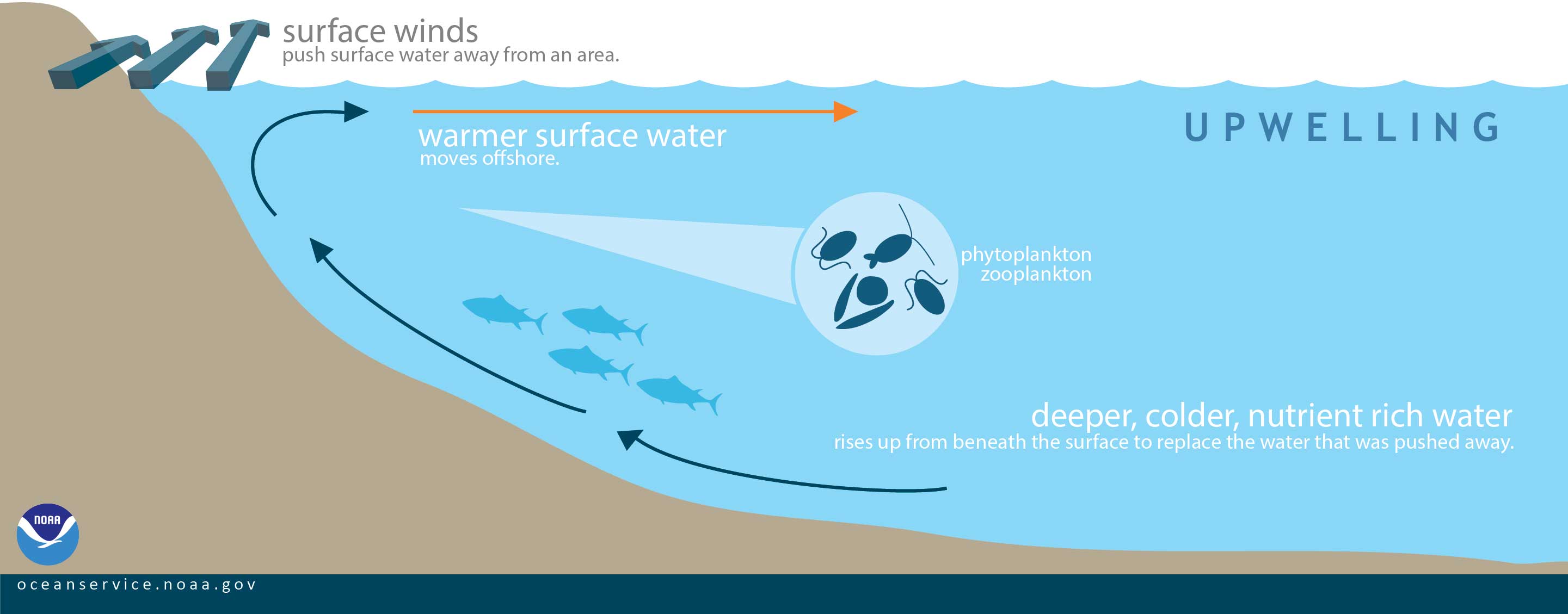
Winds blowing across the waters surface push water away. Water then rises up from beneath the surface to replace the water that was pushed away. This process is known as “upwelling.”
Upwelling occurs in the open waters and along coastlines. The reverse process, called “downwelling,” also occurs when wind causes surface water to build up along a coastline and the surface water eventually sinks toward the bottom.
Water that rises to the surface as a result of upwelling is typically colder and is rich in nutrients. These nutrients “fertilize” surface waters, meaning that these surface waters often have high biological productivity. Therefore, good fishing grounds typically are found where upwelling is common.
West Michigan saw quite a bit of rainfall over the weekend. Here is what fell over the last 3 days.

Forecast Discussion
-- Showers remain possible through today --

A few light showers are persisting over the heart of the area early
this morning. These showers are likely the result of the combination
of the large scale forcing overhead ahead of the incoming upper
trough, and the low level NE flow bringing some lake instability
inland from Lake Huron.

This upper low/trough is expected to progress through the region
through today, and be exiting the eastern portion of the area toward
00z this evening. The low and associated cold pool aloft will lead
to some light showers developing with the heating of the day.
Thunder chances look almost zero with the sufficient instability
expected to stay just east of the area. The showers should dissipate
toward 00z as the low moves out, and we lose the diurnal
heating/instability.

-- Quiet and mild weather Wednesday through Saturday --

Wednesday looks like it should be quiet across the area. The area
will be under the influence of ridging in between the departing low
to our east, and the next short wave dropping SE over the region.
This short wave will arrive on Thursday. However, it will be coming
in just after a dry period with high pressure having been in
control. Moisture will be quite limited with no influx of moisture
expected. Sprinkles look to be about the extent of any possible
precipitation.

The trough on Thursday will move out, and upper ridging will take
control of the weather for Friday and Saturday. Temperatures will
gradually warm a little each day as return flow on the backside of
the sfc ridge will gradually bring in a little warmer temperatures.

-- Warmer with chances for showers/storms Sunday-Monday --

Rain chances will then slowly increase on Sunday, and probably
peaking early Monday. Heights will build a little more toward the
area, and a warm front will be trying to nose overhead. This will
bring the instability axis closer, along with the forcing from the
warm front. Temperatures will also increase a bit more as the area
of warmth from the Plains moves in.
40’s overnight great Scotty shut the windows cool for this time of year but who’s complaining not me ..INDY
Thanks for the birthday wishes yesterday. Barry, you’re on deck.
Yup! I’m more worried about what everyone has secretly planned for me than actually turning 50.
HAPPY BIRTHDAY MARK!! Sorry it is a little late. Sounds like you had an awesome day!! To be 50 again lol!!
Currently 63* degrees out at thee YARDofBRICKS NE of GR with a cool brezze could we say it feels like Fall outside absolutely…..INDY
If you like it cooler, you better enjoy this rare period while it lasts! The heat returns soon!
Rare period lol. We haven’t had any ongoing heat since the mini heat wave a month ago Mid 80’s coming is really not that hot sorry ……But then again 60″s drain some people out so I guess …INDY
We just experienced a top 10 warmest July with only a handful of below average days the entire month. Summer has been warm and so has 2020. In fact, we’ve been warmer than average for more than 3.5 years now. I love it!
54* degrees out at thee YARDofBRICKS NE of GR overnight with some lake effect rain showers no fan attached loved it this is shaping up to be a below average week in early August seems like forever ago we had a mini heat wave now and boy it’s getting dark before 9pm let’s keep it going into September baby ….INDY
Air feels great this morning, but looks like it won’t last long. As Bill says on his blog, “ However, this is just a speed bump in an otherwise warm summer. The heat will return in full force next week.” Not looking forward to more heat.
A little more information on Lake Michigan water temperature. All of the great lakes are deep enough (only a small area of Lake Erie) so that the water temperature at the bottom is 39.4° all year long. It is only at the top were the water temperature can get very warm. The winds and sun play a part in the surface temperature. In the winter time the winds bring up some of the “warmer” water from the bottom.
Slim
It looks like the official low at GRR this morning was 57 and that will be the coolest low since June 24th. Here at my house it got down to 56 (55.6) at this time it is clear and still 56 here a my house. I also recorded 0.05″ of rain overnight.
Slim
Do you know what the coolest high temp is for today?
The coldest maximum for August 4th at Grand Rapids is 65 in 1915. At Lansing it is 67 in 1884. At Muskegon it is 66 in 1915 at Kalamazoo it is 64 also in 1915. In more recent times in 2nd place is a 68 at GR and Lansing 2017. 68 at Kalamazoo in 2017 and 70 in Muskegon in 1994.
Slim
You are awesome.
So, the 70 degree high here today really wasn’t that unusual.
No just rare lol…INDY