We had a 20-minute downpour from a storm cell that dumped .73 of an inch of rain yesterday evening around 8 pm. We have a two-day rainfall of 2.24 inches after a 12-day dry spell. This brought us up to 3.67 inches for August. The cell formed over the Otsego/Plainwell area and stayed put until it drained itself out. Our rainfall total for the met summer is now 16.56 inches which is well above normal.
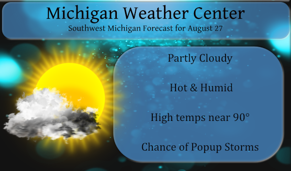
Our high temp yesterday hit 88° with a dew point at 77.2° which was our highest dp for the day just before it rained. Hot and humid weather will persist through the weekend. Much like Thursday, the heat index, or what the heat and humidity combined will feel like to your body, will reach into the mid-90s to near 100 across much of southwest and west-central Lower Michigan each day.
We have the possibility of more popup storms today though most of the area is in the 30 percentile chance of seeing one. The best chances of rain are north of Grand Rapids this morning where there are currently lines of storms and rain. The next best chance of rain comes Sunday afternoon and Sunday night.
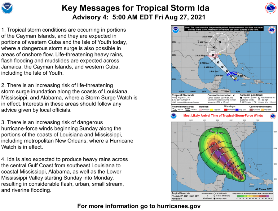
In the Atlantic we have TS Ida moving towards the southern CONUS:
Forecast Discussion
- Small chances for showers and thunderstorms today

The isolated showers that are currently occurring across portions
of Southwest Lower Michigan are near the warm front. The warm
front extends from portion of Muskegon County to the east-
southeast to near Lansing. The front is slowly creeping to the
north and we should continue to see development of isolated to
scattered showers across Central Lower Michigan and down into the
Lansing area. Southern Lower Michigan will largely stay dry early
this morning. As we head into the daytime we expected scattered
showers and storms to occur basically in the same place, across
Central Lower and for areas east of Highway 131 generally. Shear
is weak today, so not expecting severe weather which is also the
thinking of the SPC given their general thunder forecast.

- Better chance for showers and storms tonight

A better overall chance for showers and storms occurs tonight
owing to the fact that a strong low level jet will be positioned
across Wisconsin. Deep layer flow will be from the west-southwest
at 25-30 knots, so storms that form in southern Wisconsin and
northern Illinois will have the chance to spread in overnight. The
HREF shows this in the 4hour Max Reflectivity as a fair amount of
convection spread into our area between 11pm and 5am. Locally
heavy rain would be the main threat as these storms will be
running away from the low level jet and instability will be
waning.

Much of Saturday and Saturday night may end up being dry as we
will be situated in the warm section with a cold front upstream.
There is the potential for some isolated convection on Saturday is
there is enough convergence on the lake breeze. Saturday night may
see some convection try to spill our direction from upstream once
again with another nocturnal low level jet.

- Cold front still expected to bring storms on Sunday

We are still expecting a round of showers and storms on the cold
front which appears to be passing through our area in the Sunday
afternoon and evening time frame. The low level jet is on the
order of 25 to 35 knots, with a mid level jet near 40 knots.
Instability should be at least moderate as we will be in the warm
sector with surface based CAPE values in the 2500-3500 J/KG
range. Severe weather will be possible given the decent CAPE/Shear
balance. We are currently in a Day 3 marginal threat from the SPC
and could see this threat increasing as Sunday draws closer.

- Cooler and drier weather much of next week

We look to be cooler and drier much of next week as we will be
situated north of a tropical system that will be dissipating over
the TN valley. I am not sure I buy the cooler GFS as it as a +6C
over our area at 850mb on Thursday as compared to the more
reasonable +15C via the ECMWF. Bottom line though less humid and
more seasonable temperatures are expected.
Another Heat Advisiory for tomorrow. The water temps in Lake Michigan appear to be in the mid to upper 70s. Have a great weekend friends, and do your best to STAY COOL.
Air quality alert for tomorrow. Looks like it will be even hotter yet. Feels like Fall?
Now Ida may reach Cat 3 and make landfall Sunday in Louisiana – 16 years to the day when Katrina hit.
Sheesh. Now they’re saying it may become a Cat 4. It will be the 3rd major hurricane to hit Louisiana in the past year.
I wonder how far north it will go before it turns to the east?
Slim
Get ready for the cold front and seasonal temps next week and much lower humidities! Bring it!
Looks warm next week. But not hot.
70’s will feel tons better Summer is on its way out wooo woooo!! Halloween candy is out at Meijer!! INDY
84 next Friday. Phew! I love long summers!
It has been very warm (by Michigan standards) and extremely humid this summer it now seems that the past few summers have seen more humid days then what some remember in the past. I know I have had a dew points this year of between 75 and all the way up to 80. I have to wonder if it is getting more humid more often as to what is causing that. I know that the warmer it is the more water air can hold is that may be a reason but there has also been the case as to all… Read more »
A 2018 paper in the Annals of the American Association of Geographers, stated that observations “indicate an increase in regional dew point” across the Midwest associated with corn and soybean evapotranspiration.
Of course, warming temps also play a part as well. So yes, it is getting more humid and nighttime lows especially are increasing.
I wonder if this is figured in the global warming factor?
Grand Rapids now has had 3 days in a row of 90 or better and is now up to 5 officially for the summer season. I had 0.83″ of rain yesterday afternoon in a very heavy downpour. No rain was reported officially for Grand Rapids. The overnight low both here at my house and officially at GRR was 71 At this time it is mostly cloudy here and 73 with a dew point of 71.
Slim
Phew! Three 90+ days in a row!
Some lightening to the East on the way in this morning but no rain here. Other than some sprinkles the other day we have not had any rain in about 10 days since the big storms last week. Nice cloud formations all around though the past few days.
Getting up for work at 4a.m. and it’s still 75 degrees out is getting sickening. Can’t wait till someday overnight temps can actually drop down to normal.