We had no rain yesterday and it remained dry in most of Michigan with the exception of the moist air and people suffering in it. Yesterdays high in Otsego was 87.8° with a 79.5 dewpoint. The daylight continues to get shorter – sunrise today is at 7 am, sunset is 8:26 pm.
Knowing Michigan’s climate history I would suggest it will be a shock when we have a sudden shift in weather patterns and we suddenly turn to fall-like conditions, after all, met fall begins in just a few short days.
NWS Hazardous Weather Outlook
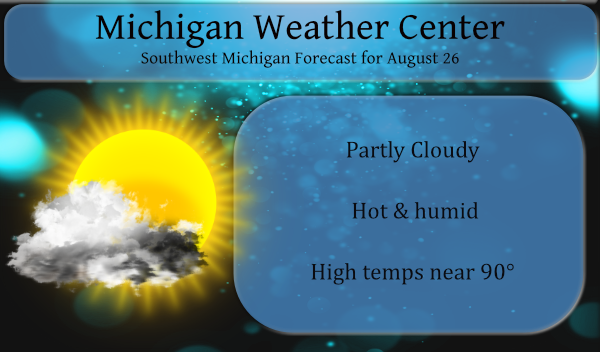
Scattered thunderstorms are likely this afternoon and evening.
Severe weather is not expected. Storms today will be capable
though of locally heavy rain, lightning and wind gusts to 35 mph.
Additional storms are expected tonight, these storms will remain
below severe levels as well.

It will continue to be hot and humid today with highs up around 90
degrees and heat index values in the upper 90s.
Looking at the above statement I would have to say that we have only a 10 to 20% chance of rain though chances increase along the southern borders where rain may be more likely today. Today will be similar to yesterday with hot and muggy conditions which will persist right on through the weekend. Our best chance of rain will come tomorrow where rain chances rise to 50%.
Forecast Discussion
- Scattered storms at times today through Friday

An outflow boundary/effective front is located across portions of
Northern Illinois/Indiana and Ohio. This boundary will move little
today but it will nudge north a bit into far Southern Lower
Michigan. We feel this boundary and the lake breeze front will
touch off some isolated to scattered showers and storms this
afternoon and evening. The SPC HREF supports this thinking as does
the 3km NAM. A weak shear/moderate CAPE environment should mean
most if not all storms will remain below severe limits today.

Tonight the boundary across Southern Lower Michigan will be easing
north through the area. The SPC HREF and 3km NAM indicate
scattered storms are possible tonight as the boundary nudges
northward. Instability will be on the decrease overnight so not
expecting severe storms tonight either.

Friday...the warm front will remain in the area and expecting some
scattered showers and storms once again. Biggest threat from
storms through Friday will likely continue to be locally heavy
rain. PWAT values remain in the 1.50 to 2.00 inch range.

- Drier period potentially from Friday night-Saturday night

Cannot rule out some showers and storms during this period, but it
looks to be more of a relative minimum through the period. We
will be situated in the warm sector with the cold front well west
of the area. Aloft, broad ridging will be in place across the
area. So, not anything synoptically to point to as a focus for
storms. We may see upstream convection make a run into the area
from the west at times and this may occur Friday night.

- Storms along a cold front Sunday into Sunday night

Showers and storms have a better chance of occurring Sunday into
Sunday night along and ahead of a cold front that will traverse
the area during this time frame. The associated shortwave though
will pass off to the north of our area across the northern Great
Lakes. Forcing will largely occur from the cold front itself.

- Drier and slightly cooler early to mid next week

A drier and slightly cooler period will occur early to mid next
week it appears. The ECMWF is indicating surface high pressure in
place the bulk of this time frame over the Great Lakes. It appears
that the high will be nearly stationary as remnants of a tropical
system potentially lift into the mid Mississippi Valley.
To conclude today’s post I submit to you a song that was popular back in the early 60s when I was growing up – Nat King Coles Lazy, Hazy Crazy Days of Summer:
The heavy rain has moved just north of me! It looks like Cedar Springs and North is getting hammered! Wow!
Downpour as we speak! Incredible!
Wow, It did not rain for all that long but it came down very hard. I just checked and there is 0.83″ in my rain gauge. And there is now a lot of thunder off to my east. It did drop the temperature down to 77 and it now feel nice out. Will go for my walk in a little while.
Slim
Nice
4th day out of 5 over 90 degrees here. Topped out at 92 with a 101 heat index. This just plain sucks.
Getting a very heavy shower. The road is flooding out. I will post a rain fall amount when the rain stops.
Slim
Great Scotty Fox weather 7 day forcast shows 70’s coming is this it with the heat we shall see bring on September ….INDY…
Fantastic and the summer of no heat
Waves rocks on with no change in sight! Who would have thought?
I noticed that some schools due to the heat are only going a half day today. I would say that hot days was to be expected when schools open in August and there are building with no AC. But then again it gets hot in September and it can get hot in May and even early June when school was always open. Hum soon there could be “heat” days to go along with snow days.
Slim
One district in this area is closing early today, although today will be cooler than the past two days when they did not close early.
The overnight low here at my house was 71 the official overnight low at GRR was 70. With a current mean of 73.4 August 2021 looks like it will have a chance of ending up in the top 10 warmest Augusts in Grand Rapids. This August has been very steady with just a few cool days (only 3 days when it did not reach 80 at GR) While only 2 days have gotten to 90 or better there have been 4 nights when it has not gotten down below 70. and 14 nights when the low has not gotten below… Read more »
74 at 6am. Thank goodness for A/C. The average high is only 79. Looking forward to next week when it finally cools back down to avg temps.
I enjoyed the NKC vid. Any idea what show that was from? Ed Sullivan maybe?
1963 BBC special “An Evening With Nat King Cole”.
👍
Looks warm next week as well.
Phew! Can we go for three 90+ days in a row?!
It is kind of unusual for it to be this warm for so long in late August here in this area.
Slim