If you hadn’t noticed I am working with some new forecast graphics. Being a part of a duet I am not sure how I am going to proceed with these so bear with me. I have a few gigabytes of weather graphics I have collected over the past couple of years and have decided to put these to use. Most of what I have purchased is for use on larger media such as broadcast weather reports so I have to scale everything down to work with web media.
We had only a trace of rain overnight and any residual showers today won’t amount to much
Weather History – SE Michigan
March 21
On March 21, 2012, high temperatures of 84, 86, and 87 were recorded in Detroit, Flint, and Saginaw respectively. All of these temperatures broke the all-time March records for warmth at each location. Saginaw was particularly impressive, shattering its previous all-time March record of 83 by four degrees. Ultimately, one more record-breaking day in Detroit would relegate this day to be its second warmest March day ever recorded. The records for Flint and Saginaw, however, still stand.
Also on March 21, 2008, a winter storm hit the greater Metro Detroit region. While most of the metro area received 3 to 7 inches of snow, a band of 8 to 10 inches fell from Dexter and the Irish Hills across Saline, Tecumseh, Dundee and into Temperance.
Also on March 21, 1913, powerful winds swept across Southeast Michigan as a strong cold front moved across the state. The wind storm was one of the strongest in the local climate record and caused widespread damage, countless injuries, and several fatalities.
According to the historical record, east winds gusting to around 30 mph during the pre-dawn hours turned to the south, allowing the temperature in Detroit to rise to 57 degrees by 9 a.m. With the passage of the cold front, temperatures fell precipitously through the day, reaching a low of 23 degrees by midnight. As the cold air first began spilling into the area, winds initially turned southwesterly and began gusting to over 60 mph between 9 a.m. and 10 a.m. The average wind speed during the following hour increased to 71 mph with a peak gust of nearly 80 mph. Shortly thereafter, at 11:15 a.m., a peak wind gust of 86 mph was recorded. Altogether, winds gusted in excess of 70 mph for approximately 3 hours while gusts in excess of 60 mph continued for around 6 hours.
Damage was significant, widespread, and conservatively estimated at $500,000 (equivalent to $11,500,000 in 2012 dollars after adjusting for inflation). Buildings were razed, roofs and chimneys were destroyed, and trees were broken and uprooted. In addition, vehicles were overturned and there were accounts of a delivery wagon having been blown through the window of a restaurant on Lafayette Boulevard. In addition to several fatalities, one of which included a Grand Trunk watchman who was blown in front of a moving train, injuries to pedestrians were numerous and included arm, leg, and skull fractures. The strong winds also caused the Detroit River level to fall so low that the water intakes for manufacturing plants were cut off, resulting in their closure. On the Canadian side, thirteen freight train cars were derailed by large waves.
March 22
On March 22, 2012, an unprecedented spring heatwave, and quite possibly the most anomalous weather event in over 130 years of record-keeping in Michigan, came to a close. The high temperature of 86 was the warmest March temperature ever in Detroit, beating by two degrees the record of 84 degrees set the day before. Highs of 84 and 75 in Flint and Saginaw fell short of the all-time March records set the day before. However, the 84 degree high in Flint still tied for the second warmest March temperature on record (Flint also reached 84 degrees on March 20, 2012 and March 22, 1938).
Altogether, SE Michigan shattered all significant records for March warmth. Detroit set 6 records in 8 days, including tying or breaking the monthly record twice. Flint set 8 records in 9 days, including tying or breaking the monthly record three times. Saginaw set 6 records in 8 days, which also included tying or breaking the monthly record two times.
The heatwave also included 10 consecutive days (March 14-23) of 70 degrees or higher in Detroit. This has never happened in March. In fact, it has never even happened in April. The closest competition is a span of 9 days late in the month of April over 125 years ago, in 1886.
Also on March 22, 1938, the daytime temperature soared to 82 degrees in Saginaw county, which ties for the third-highest maximum temperature recorded in Saginaw in the month of March.
March 23
On March 23, 1888, the daily records for both Lowest Maximum Daytime temperature and Overnight Low temperature were set at 18 and 2 degrees, respectively in Detroit.
Also on March 23, 2011, a snowstorm started on the 22nd and continued into the morning hours as it hit the Flint, Saginaw and Thumb regions. 4 to 8 inches of heavy, wet snow fell. For areas along the I-69 corridor, a tenth or two of ice fell on top of the snow. The combination of snow and ice lead to over 10,000 customers without power.
March 24
On March 24, 1965, Flint set a record low with -7. Three days later in 1965 Flint fell to -2. These two dates are the latest in a year that Flint has recorded below zero temperatures.
March 25
On March 25, 1945, record high temperatures for the day were set simultaneously in Detroit (78 degrees), Flint (79 degrees), and Saginaw (80 degrees)!
Just two years later on March 25, 1947, a snowstorm dumped 13.3 inches on Saginaw. This was the 11th heaviest snowstorm in Saginaw history.
March 26
On March 26, 1968, an F2 tornado hit Monroe County causing approximately $250,000 in property damage.
Also on March 26, 2007 the temperature soared to 81 degrees in Detroit breaking a record for the date. Flint and Saginaw both hit 76 degrees. On the next day, Detroit once again hit 81 degrees to set a record. Detroit has only reached 80 degrees or higher 12 times in the month of March, twice in March 2007.
March 27
On March 27, 1934, a record low temperature of 3 degrees was recorded at Detroit Metro Airport.
Also on March 27, 1991, one of the largest tornado outbreaks hit Michigan. Fifteen tornadoes moved across parts of the state, making it the third largest tornado outbreak by the number of tornadoes, and certainly the earliest tornado outbreak in Michigan history. Three tornadoes hit portions of Southeast Michigan including two in Monroe County and one in St. Clair County.
Weather History – SW Michigan
March 21
1983: Spring starts on a snowy note with record daily snowfall of 6 to 8 inches from Muskegon to Lansing.
2008: A record 6.6 inches of snow fell at Grand Rapids on the first day of Spring. Muskegon had a record 7 inches, while 8 to 14 inches of snow fell south of a line from Holland to Jackson.
March 22
1938: Temperatures soar into the 80s during one of the warmest March days in Lower Michigan. Grand Rapids ties their record high for the month at 82 degrees and Lansing sets a record for the date of 81 degrees.
March 23
1956: A snowstorm drops from 6 to 10 inches across southwest Lower Michigan. Jackson picks up 10 inches of snow and Grand Rapids a record 8.4 inches
March 24
1901: A tornado killed one person and injured four others in Kalamazoo County as it moved from Vicksburg to Scott.
1904: Tornadoes hit Muskegon and Grand Rapids. In Muskegon, five homes were unroofed or torn apart on the lakefront at Harrison Street. In Grand Rapids, ten people were injured as the tornado damaged a church and several barns.
March 25
1954: Heavy rain and high winds occur as a cold front moves through. Grand Rapids measures 2.82 inches of rain for their wettest March day on record. Flooding of streams is widespread and winds gusting over 70 mph causes roof damage and uproots trees.
1974: Grand Rapids falls to one below zero for its latest subzero reading on record.
March 26
1934: A record snowstorm began across southeast Lower Michigan with around a foot of snow falling at Jackson, Lansing and Battle Creek. Snow totals dropped off quickly to the northwest with Grand Rapids getting only about an inch.
1993: Dense fog caused a fatal airplane crash at Ludington. The pilot was trying to land in near-zero visibility and collided with trees and terrain on his second approach to the airport. The pilot was seriously injured and his wife, the only passenger, was killed.
March 27
1991: A tornado outbreak hits the Midwest, wreaking havoc from Iowa to Ohio. In Michigan, at least seven tornadoes strike. Eighteen people were injured in Calhoun County as eight homes were destroyed there.
Forecast Discussion
-- Showers and storms Today with lingering Fire concern --

07Z Radar continues to show scattered showers across southern
Michigan with a large cluster of showers moving along the I 69
corridor and moving to the northeast. Short range models
continues shows these showers continuing through the morning
hours. Currently there is a line of convection in Illinois that
will be moving to the northeast across Indiana and into Michigan.
This line is a feature of an upper level short wave that as it
swings through the region will bring the best chance for
thunderstorms today. Latest models have brought in a big more mid
level dry air, which will reduce convection, along with a
reduction in CAPE. However the winds through 925 mb and above are
strong, with greater then 40kts. So strong winds aloft and speed
convergence will bring enough shear to aid in thunderstorm
development. SPC`s day 1 outlook has the north and west quadrants,
including Lansing and Jackson outlooked for Thunder this
afternoon. The warm air out ahead of this system, will help. While
the scattered showers overnight has brought some precipitation to
the tune of around 0.15 along the lakeshore, it brought less then
a tenth to central southern Michigan. So the gusty winds, which
will be 30 to 35 mph, will again couple with the 20 to 25 degree
above normal temperatures to bring another day with elevated fire
danger.

-- A Round of heavier showers Thursday night into Friday --

The lingering fire danger will finally be put to rest Thursday
into Friday. A larger more significant system will move through
the south, tapping Gulf moisture and from 18Z Thursday to 18Z
Friday, will bring on and off widespread showers. NAM Nest showers
decent convection and the mid range models and ensembles are
coming into fair agreement. This system is in the form of a a
closed surface low aided by a deepening trough aloft. Currently a
0.5 to 1.25 of precipitation remains possible. That amount of rain
should quench the soils and fine fuels, ending any threat of
brush/grass fire for now.

--- Wetter and colder pattern through the weekend --

These systems will be the signal for a pattern shift through this
weekend. A large upper level trough will deepen into the US and
extend from Central Canada and into Oklahoma swinging through the
Great Lakes States over the weekend. This trough will have about
half as much moisture as Thursdays system, but will also be
bringing in some colder air. So a springing clipper could bring
some light snow to the northern tier counties, especially along
the US 10 corridor Saturday into Sunday. The Polar Jet will drop
to the south which is a good signal for colder air and increased
snow probabilities. Temperatures will be slightly below normal,
but will feel cold as it has been so warm this week.
Rocky at his best this time of year hilarious if you ask me keep up the good work my friend even better now that it’s Spring ..just think 9 months from today Christmas Eve baby ….From a humid orange beach alabama this is INDY…Have a good WEDNESDAY! INDY
You know it INDY! This past winter was incredible and great for skiing! One of the better winters in years!
Facts! It was an awesome winter for skiing! One of the best! No real warm ups, near normal temps and plenty of snow! Who knew? Fantastic and incredible!
Good day to fly a kite. We got some rain overnight. The lawn is now a bit green instead of completely brown. We received two decent, but short showers today. Mark Torregrossa on MLive says some of us may see some decent rain tomorrow night. That would be very helpful.
https://www.mlive.com/weather/2021/03/heavy-rain-to-cover-much-of-michigan-see-where-how-much.html
Looking forward to the cool down so the allergies go away!!
A couple day cool down then back to the 60’s next week!! I love long springs!! Fantastic golf weather 3 weekends in a row now!! Who knew?!?!!
https://weather.com/weather/tenday/l/b4ea0280869baa46799dc75eacef8904785ec43ad2f6fb098355fbc208a55e2c
I love this directly from the GR National Weather Service!
So a springing clipper could bring
some light snow to the northern tier counties, especially along
the US 10 corridor Saturday into Sunday. The Polar Jet will drop
to the south which is a good signal for colder air and increased
snow probabilities.
You’ve been inaccurately telling us snow has been coming for over a month now. In the beginning of March, you said the month would be cold and snowy. Whoops!
Yesterdays official high of 74 tied the record for March 23rd at Grand Rapids.
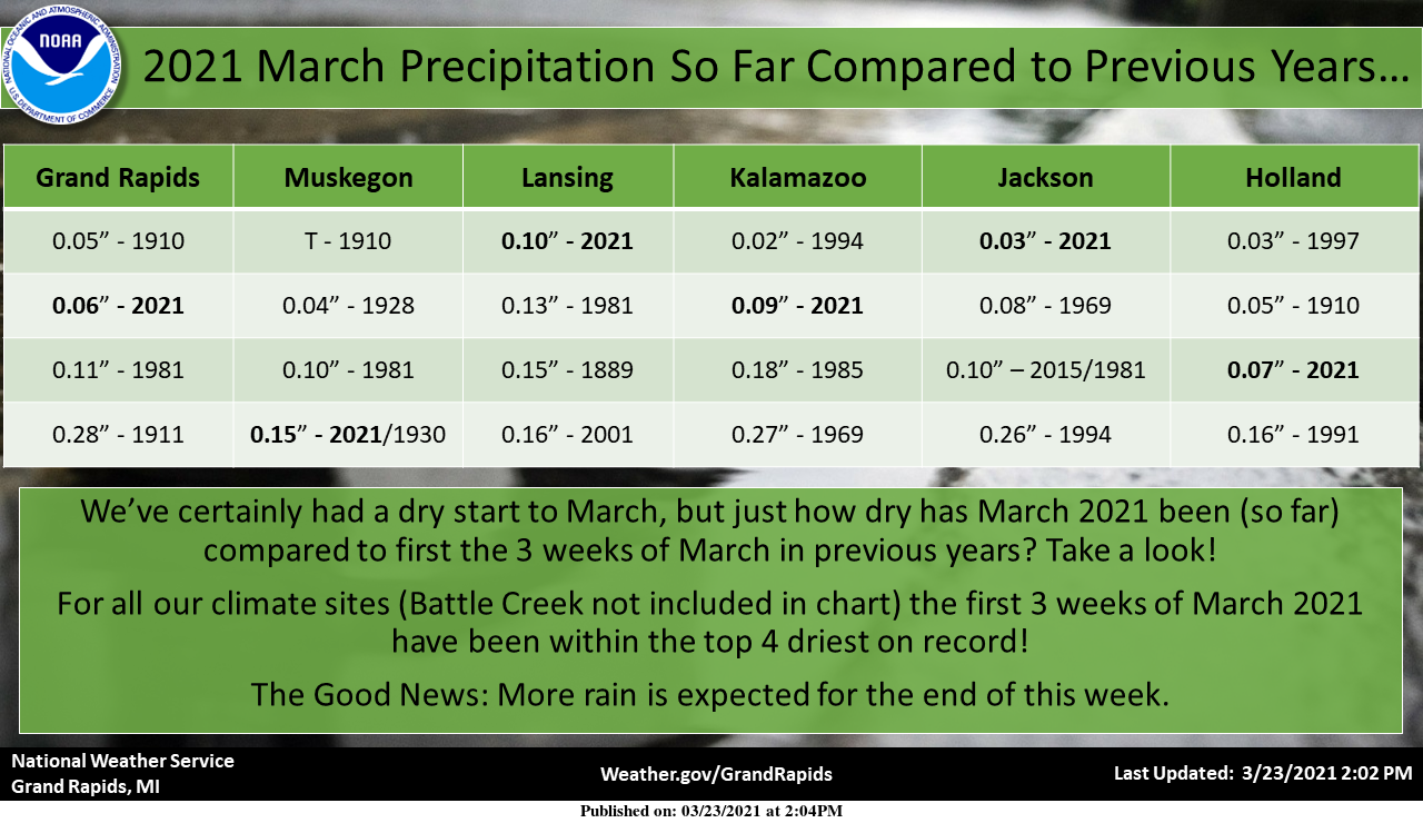
There were new record highs set yesterday at Muskegon 74. Lansing 73 and the high of 74 at Grand Rapids tied 1907 for the record. It also was the warmest March day since 2012 at Grand Rapids and Muskegon and since 2017 at Lansing. I have recorded 0.12” of rain so far today and the overnight low was a mild 53.
Slim
Here is a recap of the past met winter. The mean temperature at Grand Rapids for met winter 2020/21 was 27.1 the current 30 year average is 26.8 so last winter was just 0.3° warmer. The average high was 33.3 that was just +0.2 above average the average low was 21.0 and that was +0.5 above the current 30 year average. The highest high was 53 on 12/10 and 12/23 the lowest was -12 on 2/17. There was just 45.4” of snow during the meteorological winter with 30.6” of that falling in February. For the winter season so far just… Read more »
So basically we had a normal temp winter despite the constant warm weather hype! No surprise! Incredible!
And basically we had a much below average snow Winter despite the constant hype about all the snow coming and a “back loader” Winter.
This is only meteorological winter. If you did official winter, it was warm and snowless. I love it!
WOOD forecasted 68 degrees yesterday. It ended up making 74 degrees in GR. Wow!