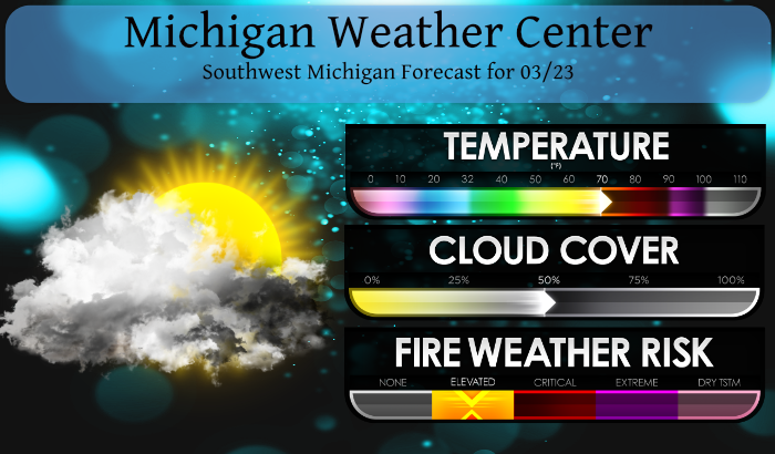
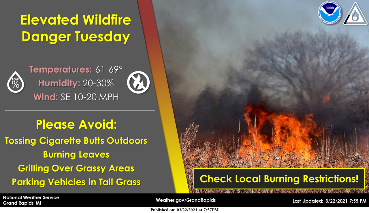
Our local fire department has been busy the past couple of days putting out ground fires. There was a fire up the road from me yesterday from a person burning leaves which got out of control. With the wind, dry conditions and low dewpoints, we have elevated risks for wildfires.
Our chances of rain increase as we go into the evening though amounts will be meager at best with under a tenth of an inch expected. With the dry air in place, it will take a strong system to butt the dry air out of the state. Today will be breezy and warm with high temps near or exceeding 70° once again. We reached 71° yesterday with humidity levels at 30%.
We will see a pattern change coming as we progress through the rest of the week with better shots of soaking rains and perhaps a chance of our first storms of the season as cooler air invades the Great Lakes region – there have been some mumbles of perhaps some snow late in the weekend.
-- Elevated Fire Danger again today --

One more day of warm dry and windy conditions will allow for
elevated fire danger this afternoon. A negatively tilted ridge
will keep the region dry this afternoon. Winds will predominately
from the south with wind gusts upwards of 20 mph. The warm trend
will continue with warm air advection continuing through today and
tomorrow. This will allow for temperatures to be 20 to 25 degrees
above normal with Max temperatures from 65 in the north to 75
along the I-94 corridor. The southerly flow will advect the dry
air as well which will keep dewpoints in the 20 to 30s.

-- Scattered showers Tuesday night, Storms possible Wednesday --

  A large upper level low will continue to move through the
central US this afternoon and evening which will overspread the
region tonight into Wednesday. The models are in agreement on the
position of this system and its movement so there is fair
confidence for this change in pattern. Waves of moisture will
stream into the region, however the low dewpoints out ahead of the
system will hold back most, if not all, precipitation through the
daytime. The cooling temperatures and the moistening of the
atmosphere will allow for scattered showers Tuesday evening with
some light precipitation amounts through Wednesday morning.

 The upper level, close low will make its wave through Wisconsin
with short waves moving through Michigan Wednesday. There are a
fair number of ingredients that show there is a decent chance for
thunder Wednesday afternoon. First the temperatures will remain
warm, with a lack of a cold front the warm air will remain 20 to
25 degrees above normal. There will be moisture advection aloft,
which is seen looking at the Specific Humidity EC SA tables, and
moisture at the lowest level. So there will be a warm, moist air
mass in place. There also will be mid level shear which will aid
in instability due to decent 850mb winds. Given the ample shear,
warm daytime temperatures for this time of year and some decent
unstable CAPE, there is a good chance for thunderstorms Wednesday
afternoon, especially along and eastward of the US 127 corridor.

-- Widespread soaking rain Possible late week --

A change of pattern is upon us. If you liked the warm,dry and
windy weather then unfortunately it will be an unfortunate
transition to a cooler and wetter weather through the latter half
of the week and through the weekend. A wetter system will be
making its way through the area overnight Thursday night into
Friday. there is upwards of 0.5 to 1 inch of QPF possible which
could allow for widespread rain across southern Michigan. This
will be due to an upper level low that should be drawing moisture
from the Gulf of Mexico and traversing to the northeast. There are
some discrepancies in the pattern so there is lower confidence on
timing and precipitation amount. Behind that system, a clipper
system moving along the Canadian border should bring temperatures
closer to normal with another round of precipitation possible over
the weekend.
Muskegon broke and GR tied a 114 year high temp record today. BTW, the Soo Locks open tomorrow.
Some old records falling again today. Let’s hope we’re not still setting record highs a few months from now.
Wow Tornado threat is high for Thursday down here in Alabama real storms storns don’t mess around in Alabama eather does the Sprites lol….INDY
Up to 75 degrees. Crazy! That’s about 30 degrees above average! Maybe I missed it, but does anybody have the final stats on met Winter?
The mean temperature at Grand Rapids for met winter 2020/21 was 27.1 the current 30 year average is 26.8 so last winter was just 0.3° warmer. The average high was 33.3 that was just +0.2 above average the average low was 21.0 and that was +0.5 above the current 30 year average. The highest high was 53 on 12/10 and 12/23 the lowest was -12 on 2/17. There was just 45.4” of snow during the meteorological winter with 30.6” of that falling in February. For the winter season so far just 45.8” has fallen and that is -25.5” So bottom… Read more »
Thanks Slim!
It is now up to 74 here at my house. The official reading at GRR is now up to 71. That official 71 ties 1910 for the 2nd warmest March 23rd in recorded history at GR. 74 is the record set in 1907.
Slim
Fertilizer down…and can already see our rain “dry slot” in place 🙁
Officially 70+ degrees in GR already! WOOD had 68 for today. Too cold once again.
71* degrees right now in orange beach alabama talk about a real Summer feel in March this is where it’s at the ocean is beautiful and yes our air conditioning has been running in our condo lol…Have a super Tuesday .. INDY
Hey INDY, you should head over to Pensicola tomorrow around 10 am local to check out the Blue Angels practice! You guys would love it!!!
We talked about that it’s cool every once awhile we get jets and helicopters fly overhead probably from the base in pensacola I do here it’s pretty cool watching them we also have a line of severe storms moving in I can’t wait to hear thunder ….GO BLUE!! INDY
It is now 72 here at my house and no air on LOL
Slim
.looks like I will return to 40’s when we come home Saturday love it ….INDY
We had a brush fire yesterday about a half mile away. Fortunately, the fire department is right down the street. But even so, it burned quite a bit of land in a very short time. They believe someone flicked a cigarette out of their car window – NOT SMART.
Yesterday’s official high of 69 tied 1910 for the 5th warmest March 22nd but it was well below the record high of 85 set in 2012 and the 82 that was reached in 1938. Here at my house I had a high of 71 yesterday. The official overnight low at GRR was 45 If that holds until midnight today will have the 4th warmest minimum for any March 23rd The overnight low here at my house was 43. The record high for today at Grand Rapids is 74 set in 1907 and in 2nd place is 71 in 1910. IF… Read more »
Wow, 69 degrees yesterday! 75+ degrees for parts of Michigan today. Forget early springs – I love early summer days!