I was looking at last year’s blog posts for the week of Christmas and found we had a total of 10 inches of snow from November through December 18th and 2.5 inches left on the ground on that day. That snow had melted by Christmas with warming temps into the 50s. On December 27th we had a record temp of 62°. We had similar circumstances in 2018 with a snowless Christmas, warmer than normal temps and more rain than snow in December. Both years had winters with little or no lake effect snow. Last year nearly all of our snow was from synoptic events rather than lake effect.
We have been in similar circumstances this year with less than half an inch of snow in SW lower Michigan which has set some dubious records for our area.
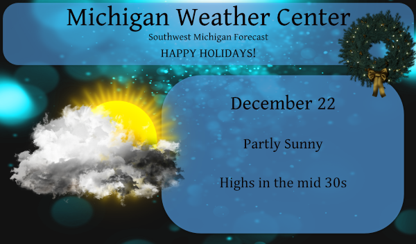
This was my forecast graphic for last Christmas:
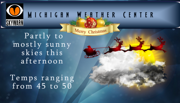
This year we have similarities with a windy Wednesday in store with highs of 45 to 50 and rain, Arctic air will sweep in on Wednesday night bringing snow showers, slick travel, and single-digit wind chills for Christmas Eve and Christmas Day. Our Christmas Eve/Day lake effect event will be dependant on wind direction. As of now, the forecast is calling for a westerly wind turning to the northwest with a couple of inches of snow into Christmas Day.
Here is the NWS latest discussion such as it is:
Both “mild” and “wild” could be an overstatement, other winters considered, but at least there`s some change in the weather on the way Wednesday into Christmas. On the heels of Tuesday`s high pressure will be a sprawling Midwest low moving toward Lake Superior on Wednesday.
Winds from the south become breezy Tuesday night, and gusty on Wednesday. Gusts 30-40 mph are possible as temperatures in the 40s to perhaps lower 50s advect into the area. The cold front moves through Wednesday night, and arctic-sourced air flows into the region.
Light rain Wednesday evening may change to snow overnight prior to ending. Support for lake-effect snow will likely begin Thursday morning and continue through Christmas. Several inches of snow is certainly possible in the NW-flow lake effect belts, and the cold temperatures would be enough for moderate impacts on road conditions.
Maybe we get a little snow in a couple days, maybe we don’t. Today will just go down as yet another well above average and SNOWLESS day to add to this amazing streak we’re on.
ARTIC BLAST COMING CHRISTMAS EVE SINGLE DIGITS WIND-CHILLS MAKE PLANS ACCORDINGLY FLASH FREZEZ WITH HEAVY LAKE EFFECT SNOW BANDS WILL DEVELOPE ROADS WILL BECOME SLIPPERY STAY TUNED!! lNDY!
I am seeing about a 5% chance of 4 or more inches of snow falling along the lakeshore counties.
Warm lake artic blast I have a feeling it’s going to pile up in some places MV I hope you got you’re Christmas food and booze ready …INDY
Sounds like you’re excited!
I am especially with the cold weather I’m ready to eat big and PARTY ….Merry Christmas!! INDY
Bring it on and let’s get this party started and rolling all the way till April with tons of snow!
YES ….INDY
BREAKING WEATHER NEWS no 50’s and 60’s this year on Christmas day let’s get this thought out early like now so we don’t have to hear about it in 2 days lol….I’m dreaming of a white Christmas…INDY
What? Cold and snow on Christmas!
Wow, a major cold front will come barreling through on Wednesday evening, bringing cold, wind and snow! Welcome to winter and there will be tons more on the horizon! I love it!
Wow, Christmas week and 50 degrees tomorrow! Just like last year. Who would have thought?
Ohhh Christmas week now I get it lol…..can we just call December Christmas month then before you know it we will be back to Thanksgiving then what ?? Turkeymas …. DDDDDD…INDY
Record snowless drought is really getting to you. Maybe next year!
No just the confusion from your response all the time lol…I say let it snow let snow let it snow DDDDDD ….INDY
Only response to a record like that is WOW. The only other record setting weather that would come close might be March of 2012.
Get to the store now winter storm warnings and advisories coming for Christmas day single digits wind-chills highs may not make 20* degrees we call this a shock and cold folks Merry Christmas…INDY
>>>>BREAKING WEATHER NEWS>>>> all of the teleconnectors are pointing to a pattern change to more cold and snow and the long range GFS is totally on board! RocK n Roll will never die!
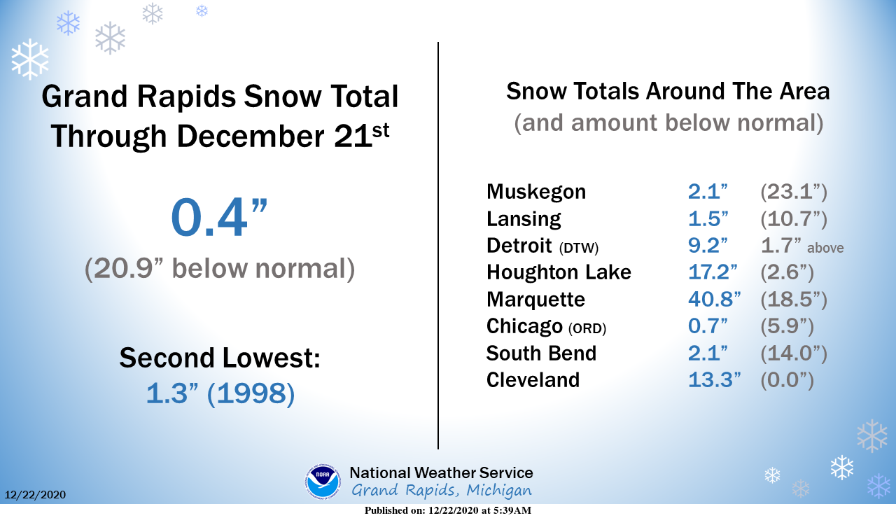
It is now official. What I have been talking about now for several days is now official 2020 will be the latest that GR has gone without a total snow fall of 1″ the old record was set in 1998. It should be noted that in the winter of 1998/99 that it turned sharply colder on December 22nd and that 7.5″ of snow did fall that December and in January of 1999 46.8″ fell that month with 40.6″ falling in 12 days from the 2nd to the 13th. The total snow fall that season was 76.7″ with 48.8 in January… Read more »
That is a pretty impressive record to break! The majority of snow that we get falls from November through February, so we are now about halfway through that time frame and still barely any snow.
The last few years we have had record snowfall in April so Winter is far from being over and April is a long ways away I agree with you Slim….INDY
LOL we saw a whopping 2″ of snow in April last year. Nice try.
Ha ha we had people scared to leave there homes becouse it’s not supposed to snow in April what?? sounds like records to me lol….I believe we even recorded snow last May also great Scotty…..INDY
GR is +2.8 degrees above average for December at the moment. How are we looking Slim for one of the warmest years on record? Top 10? This will also be our 4th straight warm year in a row.
Yes, 2020 will be a top 10 in the warmest annual. At this time the mean for 2020 is 50.2° now if that were to hold that would put 2020 with a tie with the year 1921. The 10 warmest year at Grand Rapids (that are years with all of the mounts accounted for as there are 3 with missing data) The 10 warmest year at Grand Rapids is currently 2007 with a mean of 50.2
Slim
It was hard to understand this? But top 10 huh? I’ll take it!
Bill Steffen: “I still see no big snows on the horizon”
And the longer-term models are showing more rather mild weather after our brief cool shot. I love it!
GREAT SCOTTY WIND-CHILL STRUGGLE TO MAKE IT IN THE SINGLE DIGITS ON CHRISTMAS DAY “NWS” BETTER PREPARE NOW ARTIC COLD ON THE WAY ….INDY
Get ready to rock! Can you say a major pattern change is on the way? Who would have thought?
https://www.instantweathermaps.com/GFS-php/conussfc.php?run=2020122206&time=PER&var=ASNOWI&hour=384
YES the GFS has 3 more storm systems all pointing towards the Great lakes states after the Christmas day blast so long snow drought helooooo Winter blues this will be a hard one to shovel on this blog lol… iNDY
Bring it on! Who wouldn’t want a few snowstorms during the winter season?
LET IT SNOW LET IT SNOW LET IT SNOW! INDY