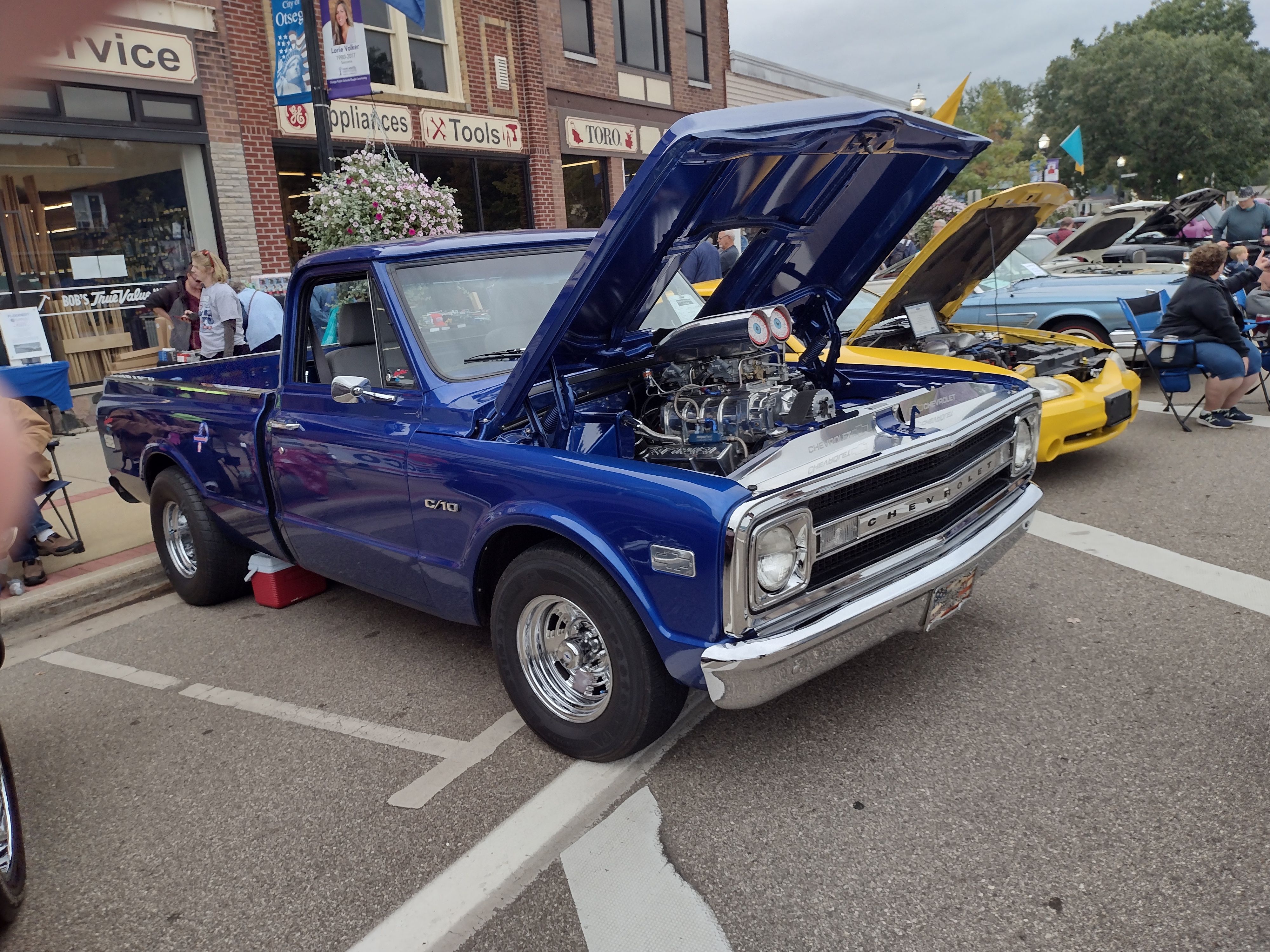
Saturday was Otsego’s annual creative arts festival. Local artists gather to sell their wares and classic cars owners and hot rodders show off their vehicles. There is also the battle of the bands at Bulldog stadium with 18 high schools competing. Needless to say, this is the busiest day of the year in our small town. Growing up in the hot rod days (had one myself) it is fun to reminisce looking at the hundred or so cars lined up on the main street.
The images are a bit large for the blog, I use the 14-megapixel camera on my phone set to produce 4000 x 3000-pixel images, here they are reduced to a third of that.
The image below is my step-daughter selling her wares – I bought a zombie bear:

Here are a few of the vehicles which filled both sides of two city blocks:


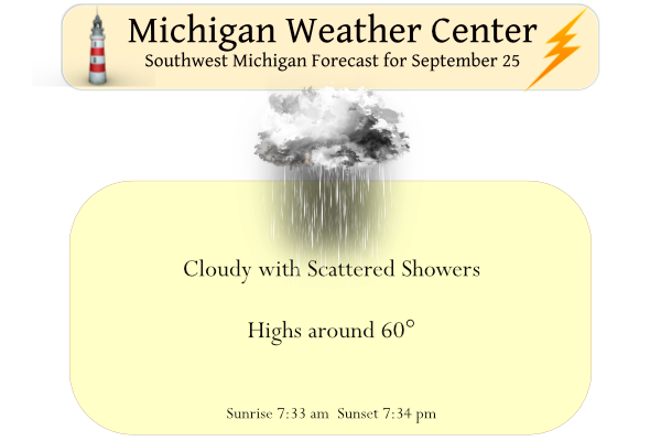
Yesterday it was cloudy with a high of 64° which was pleasant walking around the festival with a light jacket. Last year it was extremely windy and the vendors had a hard time keeping the canopies in place. Our morning low was 50°.
Today we can expect showers and isolated thunderstorms, mostly mid to late afternoon. Winds will become gusty out of the northwest to 30 mph at times by midafternoon.
Forecast Discussion
--Rainshowers with chance of Thunder Today--

A large upper level low moving through the northern Great Lakes
will continue to dominate the weather pattern for Lower Michigan
through the first half of the week.

 A short wave trough that will filter through the upper level
pattern will bring enough instability to strengthen the rain
showers that will move through Michigan this morning. Showers
will overspread with the strongest showers south of the I -96
corridor today. The strong gradient on the backside of the low
will only aid in the advection of moisture and forcing. As the
trough moves trough this afternoon, it will bring decent 0-1 km
SRH along with enough CAPE that could spark afternoon
thunderstorms. While severe is not expected there could be some
gusty winds based on the strong mid level flow.

--Gusty winds in storms with strong cold air advection tonight--

The before mentioned cold air advection will increase over the
region late this afternoon evening into Monday morning. Latest
HREF has CAPES of 500 to 1000 J/KG over southern Lake Michigan
along with 850mb winds of 40kts. The conditions over the lake will
be conducive for waterspouts. Due to the strong mid level lapse
rates, the low level jet and the incoming instability, scattered
thunderstorms will be possible tonight.


--Cold air advection will dominate the first half of the week--

Storms could linger into Monday morning as the upper level low
dips southward by 12Z Monday. A positively tilted mid to upper
level trough will only aid in any overnight convection. The
advection of cold air could also allow for hail. The quasi
stationary low will meander eastward allowing for steady northerly
flow across Lake Michigan that will cause lake enhanced
rainshowers Monday into Tuesday. These showers will be strongest
along and west of the US 131 corridor. Expect these to weaken
Tuesday as the upper level low opens up, weakens and shifts to the
northeast.

Late Tuesday night into Wednesday a building ridge over the
intermountain west will create a strong gradient along the
boundary of the exiting low. The gradient that is created will be
strongest over Lake Michigan and should create strong enough lift
through the DGZ that could result in showers and storms. Currently
the showers and storms through that timeframe should be contained
over the lake but could move onshore.
A lot of my storm chasing work is going to be on display at the Gaylord EF-3 Tornado Review gathering on Thursday. I am honored to have contributed to such a historic day in Northern Michigan weather history and to work with the National Weather Service in Gaylord. Nice to see it used in an educational setting.
If there’s a recording of the presentation I’d definitely be interested to see
Nice pics, MV
Wow, Some nice pictures. Back in the day I had a 1965 Plymouth Barracuda I would not call it a Hot Rod as it only had a 225 slant 6 in it but it was a 4 speed on the floor and for some reason many people (police) thought it was a fast car. Funny thing is at another time I had a 1961 Chevy with a 348 and that car was much faster than the Cuda but police did not have that opinion. As I said nice pictures. Note the Chevy in the picture is a 1959.
Slim
65 Barracuda w/slant-6 = all show, no go. 🙂
One can tell we have changed seasons, as after a sunny late summer and start of September yesterday was one of the first of what will be many days of zero sunshine. The official H/L at Grand Rapids yesterday was 61/51 there was a reported 0.03” of rain fall and 0% of possible sunshine. The overnight low was a mild 57 and at the current time it is 58 and cloudy. For today the average H/L is now down to 70/50 the record high of 91 was set in 2017 and the record low of 29 was set in 1947.… Read more »
MV- I like your step-daughters image of Vecna from Stranger Things 😀
I really like her Queen piece. That’s cool. A nice selection of vehicles too. The blown and blue Chevy short bed is sweet. I’d like to come to that festival.
It was a decent fall day yesterday. 64 with a mix of some sun but mostly clouds. It was first time in quite a while that I’ve worn pants (I’m a shorts kind of guy). My wife and I enjoyed the day walking around and shopping Old Town in Lansing.
I had an F-100 truck back in the mid-70s with the 351 big block, I added an Edelbrock intake and Holley 850 double pumper carb. Was a fast and fun truck to drive but you see the gas gauge fall every time you kicked it to the floor.
I did notice the $3.83 gas sign in the last pic above. BTW, it’s a sweet flame job.
If the hurricane passes just to the west of Florida then Florida could get some of the worst storm surge. My mom’s friend is on vacation on an island just off Fort Myers and plans to ride it out… doesn’t seem like the best idea to me (unless the track or intensity changes)
I think I would move back to the mainland – hurricanes don’t treat islands well.
We are entrenched in a cool weather pattern! Wow!
The Philippines has issued an extreme emergency alert as Super Typhoon Noru approaches.
The storm, known locally as Super Typhoon Karding, reached super typhoon status early on Sunday morning local time in the Philippines after suddenly intensifying.
Noru now has winds equal to a category 5 US hurricane.
It is expected to bring large waves and storm surge, torrential rains, and winds in excess of 200 kph (124 mph) to Luzon over the next 24 hours.
PAGASA issued a signal warning level four for the Polillo Islands in anticipation of extensive damage that could be caused by the storm.