Our wet month continues in SW Michigan. We had one inch of rain yesterday in Otsego which gives us 5.28 inches so far for August and 13.3 inches for met summer. Yesterday was cool by August standards with a high of 63° and a low of 54°. Below are other rainfall totals around the area.
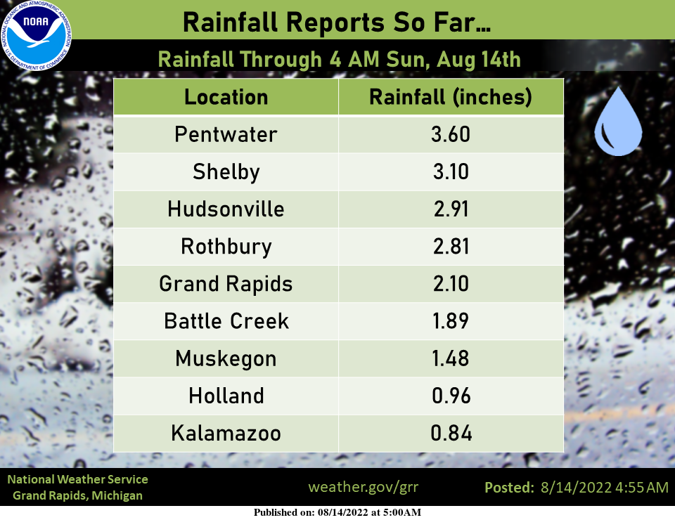
The heaviest rain of around 3 inches or more has fallen in a relatively narrow swath from Pentwater to Hudsonville.
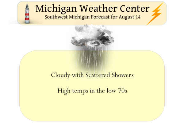
We will see another cool day again today with lingering clouds and a few light showers or drizzle. Temps will be in the mid to upper 60s, some areas may reach 70°.
Forecast Discussion
At 06Z early this morning a weak sfc low was centered over
northern IL with a sfc trough extending east near the MI/IN
border. This system will continue to move slowly ese into the
lower OH valley region by this evening. Rgnl IR sat trends and
model fcst soundings suggest that extensive low cloud cover will
linger through the day on the north side of this system.

In addition we expect scattered lingering light rain showers
and then some areas of drizzle through the rest of the day given
all the lingering low level moisture. Therefore it will be quite
cool again today with high temps only reaching the mid 60`s to
near 70 degrees.

Low clouds should finally begin to scatter out tonight as that
system moves further away from our area and our low level winds
back to the northeast to north and slowly advect some drier air
in. A ridge of high pressure will then build in and bring
predominantly fair and dry wx for most of the upcoming week along
with seasonable temps for this time of year.
Wet Fall like weekend in GR for the 2nd week of August priceless…. INDY
Incredible August cold and now another week of below normal temps! What a summer!
Now starting to get some light drizzle at my house. Driveway is starting to get a little damp.
Finally got some rain by us! 1.51” yesterday and early this morning bringing our August total to 1.56”. It’s been 3 weeks since we’ve had any decent rain. Summer total here is now 6.19”. Interesting how wide the rainfall spread has been this year from one place to another not far apart.
Starting to get some light fog developing here. 61 currently.
Like others mentioned below, I think this rain will help with the fall colors. I believe last year we had a poor color show with the dry weather… of course that is still a couple months away
I’m hoping so. I can’t wait to see the colors in the Upper Peninsula
Added another 1.06 inches of rain from midnight to 6 am which brings our total for Otsego to 2.06 inches from this system. Currently 60 degrees at 9:15…
1.3” of rain total from yesterdays event. My lawn is now a lush green after starting to turn brown earlier this summer. This is the best our lawn has looked in August I feel like In several summers.
I recorded 1.16″ during the day yesterday and an additional 1.3″ overnight for a total of 2.46″. Don’t know if anyone checked their radar overnight, but the rain was coming off Lake Michigan in what looked like a narrow lake effect band. It seems we were under the band during the night and recorded more rain than some of the surrounding areas. At least it wasn’t snow.
1.4″ at my house near Hamilton… Going to have to put on the mud boots to pick beans in the garden today.
That stubborn low is taking it’s time moving on. The downside of this is the cool temps but the upside is the rain. We’re up to more than four and half inches of rain in the past two weeks. I don’t recall it being this green in mid-August. It hopefully will make for some brilliant fall colors.
The upcoming week looks to be gorgeous with lots of sunshine.
I never remember this much rain in August within the past several years. Seems like the lawns are kinda brown and a little crunchy this time of year and even the trees seem kinda stressed and loosing some leaves. Grasses are looking great. As you said I hope this means a spectacular fall color display.
Last year we had 3.79 inches for all of August. In August 2020 we had 5.29 inches. August 2019 brought 3.62 inches of rain (these are Otsego totals.) We are now at 6.34 inches for August this year.
And the interesting thing is the 6.34 is with the month only half over. We shall see how much more we get by the 31st. I haven’t kept track of rain by the months at my house over the years. I really should start.
I’m middle aged now. The memory is the first thing to go, right??
Yesterdays high of 62 at Grand Rapids was not only the record coldest maximum for the date but it was one of the coldest maximus for any day in August! The coldest maximum for August is 59 set on August 26th 1987. It has only been 4 times since 1892 that it has been colder than 62 for the maximum on any August day. It was also the coldest high since May 22nd this year.
Slim
Two records were for any August 13th was set yesterday. The official H/L at Grand Rapids of 62/56 set a new record for the coldest maximum for any August 13th the old record of 65 was set in 1902 and 1964. The official rain fall amount of 1.85” set a new rain fall amount for the date the old record of 1.85” was set in 1994. Here in MBY I recorded a total of 1.95” of rain fall for a very wet day. There was 0% of sunshine yesterday at Grand Rapids. While the high was 62 most of the… Read more »