We reached 70° yesterday in Otsego after a morning low of 36°.
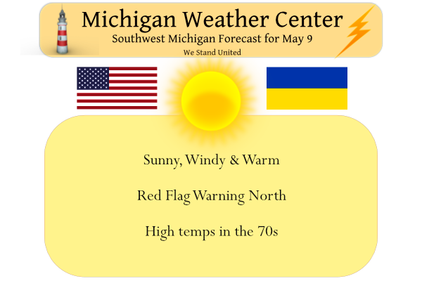
This will be a warm and dry week with above-normal temps and little or no rain.
We have a rare red flag warning for Mason-Lake-Osceola-Clare-Oceana-Newaygo-Mecosta-Isabella-Montcalm-Gratiot counties from 8 am to 8 pm today.
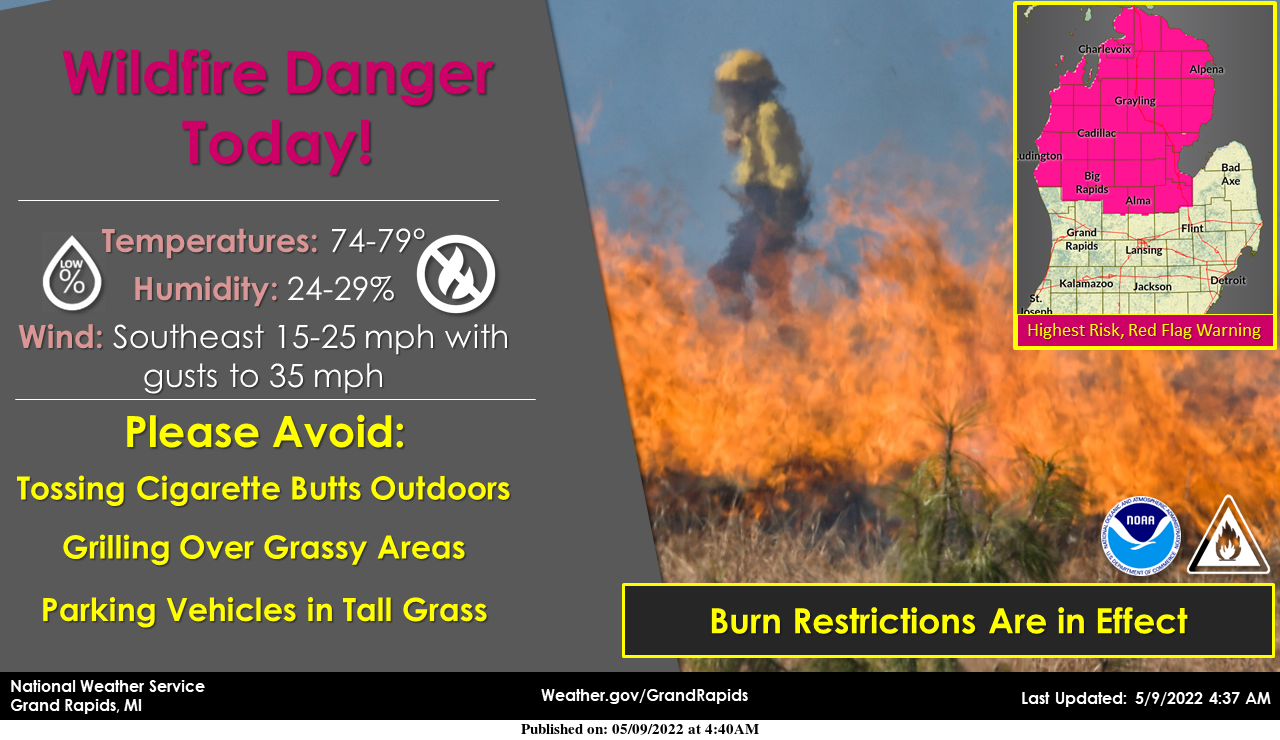
Warm temperatures in the 70s, gusty winds to 35 mph, and low humidity levels will combine to produce a wildfire danger today. The highest risk is across central and northern Lower Michigan where full green-up has not yet occurred.
The National Weather Service in Grand Rapids has issued a Red
Flag Warning, which is in effect from 8 AM this morning to 8 PM
EDT this evening. The Fire Weather Watch is no longer in effect.

* Winds...Southeast 10 to 20 mph with gusts up to 40 mph.

* Relative Humidity...As low as 24 percent.

* Temperatures...In the upper 70s.

* Impacts...burn restrictions are likely in effect. for more
  information on burn restrictions...visit the michigan dnr
  website at www.michigan.gov/burnpermit or call 866-922-2876.
A Red Flag Warning means that critical fire weather conditions
are either occurring now or will shortly. The combination of
strong winds...low relative humidity...and warm temperatures can
contribute to extreme fire behavior.

Be careful with any activities that could potentially lead to a
wildfire. Camping...outdoor grills...smoking materials...chain
saws...and all terrain vehicles all have the potential to throw a
spark and ignite a dangerous and destructive fire.
- Much Above Normal Temperatures With Few Rain Chances This Week

Ensemble and deterministic guidance continues to indicate above or
even much above normal temperatures this week. EPS 850 mb
temperatures around 2 standard deviations above normal are indicated
across the Great Lakes, which equates to about 10C above normal for
this time of year. Translating that to surface temperatures, it
appears that low to mid 80s should overspread the region (even
toward the coast at times given SE winds) especially Wednesday
through Friday. Some locations could reach or break records during
this warm stretch if mid 80s can be achieved. After coming off a
colder than normal April and starting off May also colder than
normal, this will be an abrupt shift into an abnormally warm pattern
for Southwest Lower Michigan courtesy of 500 mb heights rising into
the 590s (dm) with an omega block setting up, and the associated
surge of abnormally warm 850mb temperatures.

After a dry day with low RH values (see Fire Weather section below),
the advection of higher dew points commences Tuesday and especially
Wednesday with mid to upper 60s arriving by that time. We have also
noticed via Bufkit RH cross sections (ie. Nam, GFS) that some lower
cloud cover may develop on Tuesday, at least in the morning, but
potentially continuing into the afternoon. While current forecast
highs are in the upper 70s to around 80 for Tuesday, it is possible
that temps could be held down a few degrees lower than that if cloud
cover locks in. Upstream convective development across Wisconsin
looks probable on Tuesday into Tuesday evening, though given the
orientation of the weak LLJ and also where SBCAPE will be maximized,
it seems more likely that any storms that form over eastern and
central WI will likely propagate more south than east. Still, it is
not impossible that some storms try to make the trek over Lake
Michigan and our lakeshore area could get clipped with a shower or
storm late in the day or evening.

For Wednesday, the center of the upper level ridge is nearly
overhead. As mentioned, dew points will be in the mid to upper 60s.
If we can develop a lake breeze on Wednesday, it is possible we
could pop a few diurnal showers and thunderstorms. Sufficient
surface based instability will be present along with low level
moisture, though soundings are awfully dry above 700 mb for
Wednesday. As such, slight chance POPs seem warranted. Most
locations will likely stay dry Wednesday but a pop up shower or
storm is not out of the question.

After warm and likely dry days for Thursday and Friday, we are
probably looking at a cold front passage Saturday or Sunday with
increasing rain chances. Timing is uncertain, so it is possible
that Saturday continues to stay warm in the 70s to around 80. An
upper low developing in the northern Plains at that time may be
strong enough to squash the ridge and bring in cooler temperatures
to the Great Lakes heading into early next week.
Enjoy your brief time with summer temps, because that will be it for awhile! Incredible!
Saturday maybe in the 60’s now with low 50’s at night that just maybe perfect fire weather its been awhile since we burned a good fire Spring and Fall are the best times of year for fires ….InDY
Our local TV met says 80 here Saturday.
Spent the day today cleaning the basement out and getting rid of things I don’t need. We have community garage sales coming up so I’ll be getting ready for those. It is possible within the next year or so I may be moving to Alabama so need to get things in order.
Upper 70’s with lots of sun! Does it get better than this in early May?
Currently it beautiful outside getting lots of yard work done today anybody noticed the slight risk area for storms in Wisconsin? Msybe tomorrow we get a thunderstorm …INDY
I also have been out doing some yard work and yes it is sunny and very warm but there is a nice breeze. But it has been so cool it feels very warm, time to bring out the shorts.
Slim
70 degrees before noon. And getting even warmer this week!
Well it’s a new month and the fact remains this has been a very cold year! Well below normal temps current year to date! Wow, what an ice box year so far! Absolutely incredible!
2022 so far has been colder and wetter than average. And we are running behind in the spring green up so far and that shows with the red flag warning as the green up is behind. Of course this warm up will cause a rapid green up and by the weekend it will look like summer with full leaf out.
Slim
Well, it’s a new month and the same trends hold. GR is once again the coldest of the big 3 reporting stations and also the coldest relative to average. Hmmmm
GR 51.3 avg temp
Lansing 52 avg temp
Detroit 54.8 avg temp
Too funny, give it up! Your fantasies are getting old!
For locations on at 43 north Grand Rapids 51.3., Flint 51.9, Milwaukee 48.3, Madison 49.9.
Slim
I’m confused by this post. Are you falsely implying that latitude, alone, determines climate?
Latitude is the biggest factor in the climate of a region.
https://www.ck12.org/earth-science/latitude/lesson/effect-of-latitude-on-climate-hs-es/
BTW Milwaukee departure for May so far is -4.8 and Milwaukee is closer to Grand Rapids than Detroit and about the same as distance as Flint.
Slim
Rock on Slim! Keep the facts coming but as mookie stated facts confuse him! Wow!
What is your point? GR is running colder than inland Lansing (closer to the lake in spring, timing of cold fronts, etc.) and Detroit is 100 miles away and much further south, not really comparable.
That’s why there are averages in place. And yet GR has been much colder relative to their average lately. Hmmm
As I have said before if you have a issue with the reports coming from the NWS take it up with them. Not many years ago Flint was reading warmer compared to their average and I am not sure how that was (or if) played out.
Slim
Blowtorch warning! NWS talking about possible multiple record highs around Lower Michigan this week. Low temps not too far off from average high temps this time of year. I love it!
Here are the record highs for several locations in west Michigan for the rest of this week. 5/10 5/11 5/12 5/13 5/14 Muskegon | 90 (1930) | 87 (1930) | 83 (2011) | 84 (1982) | 89 (1982) Grand Rapids | 87 (1993) | 85 (1993) | 85 (2011) | 86 (1991) | 89 (1982) Lansing | 89 (1993) | 83 (1993) | 87 (1991) | 85 (1982) | 87 (1982) Kalamazoo | 83 (2004) | 85 (2011) | 87 (2011) | 85 (2011) | 85 (1998) For the warmest lows for the week are in the mid to upper… Read more »
According to the CPC, there are also hints of a warm end to May and start of June.
Enjoy the slightly above normal temps this week, because next week we swing right back to below normal temps! Who would have thought! So this week, while not a blow torch will have some early summer temps, but they won’t last! Incredible!
Yesterdays official H/L at Grand Rapids was 67/36, and that was still -4 below average for the date. The start of the day was sunny but clouds moved in later afternoon and it became mostly cloudy. So far the 1st 8 days at Grand Rapids have all been below average. It is now time to set back and enjoy a nice warm week. It still looks like we will get warm to very warm this week. But don’t get too conformable with the warm temperatures as there are hints of a cool down to once again below average temperatures later… Read more »
I believe I just heard Kevin Craig Fix news just say big cool down coming for the end of May ?? Better stack some wood for Memorial day weekend…..Wow!! InDY
Don’t know how cool it is going to get but as you (or Kevin Craig) said there looks to be a cool down after a week or so of warm temperatures. We shall see, maybe that “blowtorch” will soon run out of gas.
Slim