 Hope you all had an enjoyable Christmas.
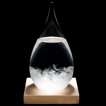
One of the more interesting gifts I received is a storm glass (to the left) from my step-daughter.
The storm glass or chemical weather glass was an instrument which was proposed as a method for predicting weather. It consisted of a special liquid placed inside a sealed transparent glass. The state of crystallization within the liquid was believed to be related to the weather. The inventor is unknown but the device became popular in the 1860s after being promoted by Admiral Robert FitzRoy who claimed that
“if fixed, undisturbed, in free air, not exposed to radiation, fire, or sun, but in the ordinary light of a well-ventilated room or outer air, the chemical mixture in a so-called storm-glass varies in character with the direction of the wind, not its force, specially (though it may so vary in appearance only) from another cause, electrical tension.”
The compositions of the liquid in a storm glass varied but usually contained “camphor, nitrate of potassium and Sal-ammoniac, dissolved by alcohol, with water and some air.”
FitzRoy carefully documented how the storm glass would predict the weather:
- If the liquid in the glass is clear, the weather will be bright and clear.
- If the liquid is cloudy, the weather will be cloudy as well, perhaps with precipitation.
- If there are small dots in the liquid, humid or foggy weather can be expected.
- A cloudy glass with small stars indicates thunderstorms.
- If the liquid contains small stars on sunny winter days, then snow is coming.
- If there are large flakes throughout the liquid, it will be overcast in temperate seasons or snowy in the winter.
- If there are crystals at the bottom, this indicates frost.
- If there are threads near the top, it will be windy.
In 1859, violent storms struck the British Isles. In response, the British Crown distributed storm glasses, then known as “FitzRoy’s storm barometers,” to many small fishing communities around the British Isles that were to be consulted by ships at port before setting sail.
I love old weather technology. We have had a glass thermometer with glass bulbs with weights attached to them which is fairly accurate. Though I wouldn’t base my forecasts on these instruments they have a place in history for those who attempted accurate forecasts with the tools they had on hand.
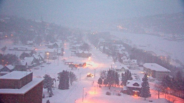
 A great day to be out if you are a penguin! Dress warm and cover all exposed skin as frostbite is a danger in less than 30 minutes in this cold. Temperatures will struggle to get into the low teens today.
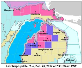
The winter weather advisory expired at 7am for most of the area with the exception of the northern counties shown in the graphic to the left where the could see up to another eight inches of snow.
Bitter cold arctic air and lake effect snow showers will continue through this week. The combination of cold road temperatures and falling and blowing snow will make for slippery travel conditions.
There will be another couple inches of accumulations across the western half of the forecast area through tonight along with temperatures cold enough to render most road treatment chemicals ineffective, so travel will still be impacted despite the lack of heavier snow.
Lake effect will wind down by Wednesday, then a low pressure center will move in Thursday morning to bring in some more snow. After the passage of the low more lake effect will enter the lakeshore counties for Friday and Saturday.
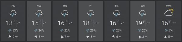
Today: Snow showers. High near 11. Wind chill values as low as -8. West wind 11 to 14 mph. Chance of precipitation is 100%. Total daytime snow accumulation of around 3 inches.
Tonight: Snow showers. Low around 4. Wind chill values as low as -3. West wind 5 to 10 mph becoming north after midnight. Chance of precipitation is 90%. New snow accumulation of around 2 inches.
Wednesday: Snow showers likely. Mostly cloudy, with a high near 12. Wind chill values as low as -2. Light north wind becoming northwest 5 to 10 mph in the afternoon. Chance of precipitation is 70%. New snow accumulation of around 2 inches.
Wednesday Night: Snow showers likely, mainly before 1am. Mostly cloudy, with a low around 3. Wind chill values as low as -4. Light and variable wind. Chance of precipitation is 60%. New snow accumulation of less than one inch possible.
Thursday: A 50 percent chance of snow, mainly after 1pm. Mostly cloudy, with a high near 14. South wind 7 to 11 mph.
Thursday Night: A 50 percent chance of snow showers. Cloudy, with a low around 9.
Friday: Snow showers likely, mainly before 1pm. Cloudy, with a high near 18. Chance of precipitation is 60%.
Friday Night: Snow showers likely. Cloudy, with a low around 11.
Saturday: A chance of snow showers. Mostly cloudy, with a high near 16.
Saturday Night: A chance of snow showers, mainly after 1am. Mostly cloudy, with a low around 4.
Sunday: A chance of snow showers. Mostly cloudy, with a high near 14.
Sunday Night: A chance of snow showers. Mostly cloudy, with a low around 5.
New Year’s Day: A slight chance of snow showers. Mostly cloudy, with a high near 13.
What a winter! Keep it coming!
http://www.instantweathermaps.com/GFS-php/showmap-conussfc.php?run=2017122618&time=PER&var=ASNOWI&hour=384
Check out the Manistee/Ludington area! Bring it!
http://wxcaster.com/gis-gfs-snow-overlays2.php?STATIONID=GRR
Let it snow let it snow let it snow! INDYDOG!
Let it SNOW and let the ROCK n ROLL winter party get cranking!!
Todays high so far at GRR is 11° this makes today one of the coldest maximum temperatures for a December 26th at Grand Rapids. The record is 10° in 1993 and the same 11° in 1990. Right now it is 10° with light snow falling.
slim
9* not thinking it’s going to get above 10* today very cold day out at thee YARDofBRICKS!!
Climatology for today December 26th At Grand Rapids, MI The average H/L here in Grand Rapids is 32/21 The record high for today is 53 in 2016 the coldest maximum is 10 in 1993 The record low is -6° in 1951 the warmest minimum is 45° in 1936 The largest snow fall is 11.9” in 2001 The most on the ground is 22” in 1951 Last year the high was that record of 53 and the low was 31° 0.16” of rain fell and the day started with 3” of snow on the ground. One more note the official December… Read more »
Yesterdays recorded 7.0” of snow fall at GRR ties the record for Christmas day with the 7.0” that fell in 1990. I now have 9.3” of snow on the ground here. Getting a typical cold weather lake effect fine snow falling here now with a temperature of +8°. Will have to wait and see what the finial low at GRR will be so far its +4° I had a low of +2° this will be the coldest December 26th here at Grand Rapids since 1993 when the low reach -4°
Slim
I got a Storm Glass for Christmas from my bro-in-law! I have to say, the Jules Verne excerpt on the box is pretty cool.
-4° here. I don’t mind snow, but I can’t stand the bitter cold. I like to be outside, but not when it’s this cold. Im just happy I did all my snow clearing yesterday. We received just shy of 6″.
Here are the FACTS:
1. Yesterday was a record setting snowfall for GR!
2. We are currently above average for seasonal snowfall and monthly snowfall! Who knew?
3. It looks like those that predicted not very much moisture available to generate decent snowfall were wrong!
4. You don’t need much moisture if the snowfall ratio is 20 to 30:1 and cold air is flowing over the lake!
5. Skiing will be INCREDIBLE this week!.
6. ROCK n ROLL will live forever!
The 7″ tied the record last set in 1990
Slim
Record snowfall on Christmas for GR? INDYDOG!!