The temperatures have been hovering at -2° early this morning here in Otsego with negative numbers being pretty consistent across SW Michigan with the exception of the lakeshore where they have been above 0°. Temperatures in the northern lower and the U.P. are in the double digit negative numbers. Looking at the long range it appears this Arctic airmass will be dug in for the long term.
Erie Pennsylvania has broken an all time record of snowfall with 63 inches since Christmas Eve. This is from a persistent lake effect band coming across the length of Lake Erie. Needless to say things have come to a standstill for the area. The lake effect is expected to wind down this evening but not before dumping another 8 inches of snow.
Nothing that spectacular for us in the short term. Our main story is the bitter cold with wind chills remaining below zero throughout the rest of the month on into January. Normal high temperatures this time of year are near to just below freezing, and normal low temperatures are around 20 degrees.
We have another system moving in for Thursday afternoon into Friday giving us a synoptic event with some lake enhanced snow then lake effect with winds out of the northwest. We could see another 4 to 8 inches of snow along the lakeshore counties and probably Kalamazoo. I am thinking we will see some advisories showing up in SW Michigan late tonight, early tomorrow.
Friday night into Saturday another short wave will drop over the state bringing with it more snow though it is uncertain how much at this time. Needless to say our pattern of cold and snow aren’t leaving anytime soon. Looking at the Bittersweet webcam yesterday I can see business is good as huge lines were waiting for the cable to take take people back up the hill.
Today: Snow showers likely, mainly before 3pm. Mostly cloudy, with a high near 12. Wind chill values as low as -11. Calm wind becoming northwest 5 to 9 mph in the afternoon. Chance of precipitation is 60%. Total daytime snow accumulation of around 2 inches.
Tonight: A 30 percent chance of snow showers, mainly before 10pm. Mostly cloudy, with a low around -4. Light and variable wind.
Thursday: A 30 percent chance of snow showers, mainly after 1pm. Mostly cloudy, with a high near 13. Wind chill values as low as -12. South wind 6 to 10 mph.
Thursday Night: Snow showers likely, mainly after 1am. Cloudy, with a low around 7. Wind chill values as low as -8. South wind around 10 mph. Chance of precipitation is 60%. New snow accumulation of around an inch possible.
Friday: Snow showers likely. Cloudy, with a high near 19. Southwest wind 9 to 17 mph becoming west northwest in the afternoon. Winds could gust as high as 25 mph. Chance of precipitation is 60%. New snow accumulation of around an inch possible.
Friday Night: A 50 percent chance of snow showers. Cloudy, with a low around 10.
Saturday: A 30 percent chance of snow showers, mainly before 1pm. Mostly cloudy, with a high near 15.
Saturday Night: A slight chance of snow showers. Mostly cloudy, with a low around 1.
Sunday: A chance of snow showers, mainly after 1pm. Mostly cloudy, with a high near 12.
Sunday Night: A chance of snow showers. Mostly cloudy, with a low around 4.
New Year’s Day: A chance of snow showers. Mostly cloudy, with a high near 13.
Monday Night: A chance of snow showers. Mostly cloudy, with a low around 4.
Tuesday: A chance of snow showers. Partly sunny, with a high near 15.
Well I guess if you have any errands to run tomorrow like I do – it might be better to do them in the morning. I didn’t think the roads were the great around here today.
Half a dozen warnings and advisories issued for counties north of Allegan from noon Thursday – noon Friday.
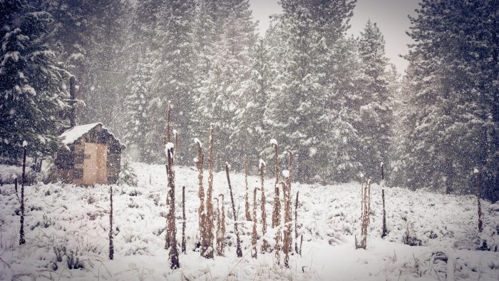
It is absolutely gorgeous out! The new snow on the trees is beautiful!! The sun keeps peeking out & it is very bright. I was taking photos of the trees & birds which have gone wild this afternoon. I will admit this bitter cold is hard to take, I hope it leaves soon! I hear we are in for some more snow & bitter temps. I’d say I have over a foot in my yard easy.
Agreed! Spectacular day today.
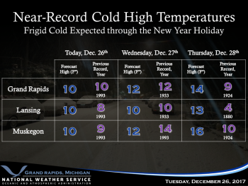
Climatology for today December 27th At Grand Rapids, MI
The average H/L for Grand Rapids is 32/21°
The record high is 60° set in 2008 the coldest maximum is 12° set in 1933
The old record low was -5° set in 1993 the new record low is now at least -10° set today!
The warmest minimum is 44 set in 2008
The largest snow fall is 9.6” set in 2001
The most on the ground is 22” in 1951
Last year the H/L was 31/27°a trace of snow fell and a trace was reported on the ground’
Slim
NEW RECORD LOW AT GRAND RAPIDS, MI
The official low at Grand Rapids will be at least -10° this sets a new record for December 27th the old record was -5° set in 1993. This is the first time it has officially gotten below zero at Grand Rapids since February 28th 2015 (-4°) and the coldest since February 20th 2015. The low here at my house was -9° (note the low for December 26th was -3°) Also yesterday maximum of 11° is the coldest high here in Grand Rapids since February 19th 2015 when the high was +7°
Slim
A buddy of mine and his wife saw light pillars this morning. He was describing them to me, but he had no idea what he was looking at. I’m like, hey, those were light pillars!
Love the light pillars! Saw them as well 🙂
I saw them as well!!! So cool!!!!
Later people. I am heading up to SNOW country! Get outside and enjoy WINTER!!!!!!!!!!!
-11 out at there YARDOFBRICKS .. new record! INDYDOG!!
And just think a few days ago we had people on here saying it doesn’t look as cold for this week and not enough moisture for good accumulating snow! INCREDIBLE!
Low temperature for today in Otsego is now -5.
-4° here but no wind, so it doesn’t feel as cold as yesterday. -10° in GR.
It’s times like these I feel for those whom do not have proper shelter.