Last week the question was asked when the new 30 year averages will come out. Well that should happen some time in 2022. But just what are the current 30 year average by month and how will they change in the next set of averages? Well here is a list of the current 30 year averages and the average over the last 10 years by month first in temperatures
January 30 year average 24.4° last 10 year average 24.5. a little warmer°
February 30 year average 26.8° last 10 year average 26.0 gotten colder
March 30 year average 35.3° last 10 year average 35.8 has got ten warmer
April 30 year average 48.0° last 10 years average 47.4 not much change but warmer
May 30 year average 58.7° last 10 year average 60.7 has gotten warmer
June 30 year average 68.4° last 10 year average 69.1 has gotten warmer
July 30 year average 72.5° last 10 year average 74.0 has gotten warmer
August 30 year average 70.8° last 10 year 71.5 has gotten warmer
October 30 year average 51.0° last 10 year average 52.3 has gotten warmer
November 30 year average 40.1° last 10 year 39.6 average cooler
December 30 year average 29.2° last 10 year average 31.1 cooler
For the year 30 year average 48.4° last 10 years 49.7 has gotten warmer
Bottom line over the last 10 years only February and November have had a average of colder than the 30 year average so most months look get a little warmer in the next 30 year update.
Now for snow fall. Below is the current 30-year average and the average snow fall over the last 10 years at Grand Rapids.
October 30 year average 0.5” last 10-year average 0.1” less snow fall.
November 30 year average 6.8” last 10-year average 5.5” less snow fall.
December 30 year average 21.9” last 10-year average 16.7” a lot less snow fall.
January 30 year average 20.8” last 10-year average 21.8” a little more snow fall.
February 30 year average 14.4” last 10-year average 21.9” a lot more snow fall.
March 30 year average 8.3” last 10-year average 5.1” a good bit less snow fall.
April 30 year average 1.8” last 10-year average 2.5” more snow fall.
For the season (October to April) the 30 year average 74.5” the average over the last 10 years 73.6” not much change. So, depending on how the next 2 years go will depend on how much the new 30 year
As I write this late on Friday night it is still very warm out and it feels and smells like spring. There is a pond near my house on my walking trail (yes 10 days into January I am still walking outside) any way I am sure it has happened before but I sure do not recall the pond being ice free in January but this year it is.


When I give my temperature reports this is the unit that they come from. and yes it is still 47° at 11:30 pm (rounded up)
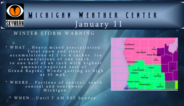
By the time you are reading this we should know if the winter storm is really a winter storm or just a rain event.
Slim

Where’s this blizzard I heard two talk about on here? I wouldn’t even call this a storm.
I absolutely love the current cpc Maps! Can you say cold and snow? Incredible!
Love the 2 month winters we’ve been having here! Gonna be another February/March Winter!! Love it!!
Looking ahead, looks like 40s again by Tuesday.. I love winter.
It’s been fantastic!! Above average temps, below normal snow! This winter is AWESOME!
The RDB model…
Really
Don’t
Believe it
model
Considering that this storm was advertised as potentially “historic” and “devastating” it sure looks like nothing more than a rainy January day that ends with a little snow at this point. The local TV weather guessers must own stock in a generator manufacturer or something.
Or have plenty of stock in oil! What a joke! Just some light snow out there now. Used to be a few inches of snow was a typical January day, Now it’s a WINTER STORM WARNING!!!! Make Meteorology Great Again!!
Was thinking the same.. Not even close to being a winter storm .. lol.. Just rain and some minor snow and ice..
Went down to GR today, the roads were just wet! Wishcasting at its best! Kirkwood is probably sitting on his snowmobile on the pavement in his driveway right now crying!
Well we know at ones certain household they will be getting over a foot tonight. Lol !!!
Blizzard conditions in Rockford I hear!
Lol!!! I’m about 10 miles directly west of there and I’m getting light snow with light winds. Must be the snow globe around his house!!
Current conditions = windy, cold, moderate to heavy snow In fact we are get pummeled with snow with near blizzard conditions! Great call Indy!
Let it snow let it snow let it snow ..Other then Zland lol….INDY
The medium and long snow maps still look rocking!
https://www.instantweathermaps.com/GFS-php/conussfc.php?run=2020011118&time=PER&var=ASNOWI&hour=384
Well 2 days ago that map gave my area 48” of snow, and now it’s down to 12”, so yes, it is “trending” in the right direction.
Wishcast
What a fail.. Lol.. Snow nuts just cannot see the truth.. Days keep getting longer. Now those are Facts !!
Utter fail!! Guess we’ll get a 1/4 inch of snow in that timeframe, since you have divide the totals by 8! The best was last year when that map predicted over a foot of snow in Pensacola Florida! We can’t post the CPC maps on here but that piece of trash instantweathermap can be posted every 6 hours on here!
Just drove home from Holland, no snow, no blizzard, but it is a steady rain now with the temp at 29 degrees. Everything is caked in ice and looks like glass in the headlights. Roads are mostly just wet, but they have to be getting close to freezing.
I like it! Bring it!
http://wxcaster.com/gis-gfs-snow-overlays2.php?STATIONID=GRR
We are getting moderate accumulating snow as we speak! The RDB forecast is right on track! The most accurate model on the market!
ADA – rain continues 🙁
We have a mini snow storm on the way over night look for 6+ inches of new snow on the ground when you wake up tomorrow in GR roads are going to become very slippery over night good thing we have a winter storm warning out …JNDY
Excellent points! Keep up the good work!
The moisture coming up from our SW had better not be an all night freezing rain “event”…there will be nothing remaining up here 🙁
Mainly snow and sleet!
Breaking news>>>>the latest CPC shows cold and snow next week and beyond! All of the teleconnectors are trending towards cold and snow! Not sure we could be seeing better news than this!
Great news! The deformation zone is looking good and heading right towards us! The trusted RDB model is still right on target and all along predicted around 3 to 5 inches of snow! Incredible!
ADA – yep…this unfortunately is freezing rain. The forecast did mention a long, dangerous timeline of freezing rain this evening…praying this isn’t it 🙁 Hate this…too many nightmares and damage from March.
The conditions are worsening here at MSU. I just took a walk around campus and all trees are covered with ice. Many small to medium size branches down. The sidewalks are becoming covered with ice (as of the past 30 minutes).
Odd weather. Sounds and feels like freezing rain at the moment. Tree branches are crackling, and whatever is landing on my coat is liquid. Let’s just go over to snow and move this ice out of here.
Official rainfall before it turned to freezing drizzle 2.46 inches in Otsego since 11pm last night. Here is the current NWS update: A second area of heavier precipitation will work across West Michigan this evening and tonight, and fall as mostly snow, sleet, and freezing rain. The area of greatest concern for power outages this evening and tonight will be along a corridor from Hastings to Lansing to Flint. This is where the highest threat for freezing rain accumulations greater than one-quarter of an inch will be. Winds will be gusty this evening and overnight, and will increase damage to… Read more »
I agree Slim. The first 12 hours of this “Winter” storm has had nothing Winter about it until maybe the past hour or so with some sleet. Seems they could have waited to start it at 2 p.m. today instead of 2 a.m., and that’s if anything else actually happens. Few days from the halfway point of Winter, and just like this storm not much Winter has happened yet.
Should have just been a WWA for the coating of ice we’re receiving! What a joke!!!
Trees are all covered with ice here at Michigan State, but the roads are just wet.
Now, that I have gotten my little rant off. In looking at the current radar the best bet for the next wave is to keep a eye on Missouri and how that snow develops and where it is heading as that will be the wave 2 So keep a eye on the snow in Missouri and how much snow falls there and to the north into Iowa and see if that moves north or north east with time.
Slim
Rock on Slim!
Looks like trees starting to ice here… pine trees looking droopy.
I don’t know if I should use the word “hype” but that sure comes to mind with today’s forecast. And I am not talking about the posters on this or any other blogs I am talking about the NWS. I know that they must error in the name of safety and all but still? I think we ALL pay too much attention to the computer models. Too much is put into trying to have the models do much of the forecasting. I was concerned yesterday when there was talk of a 15 to 30-mile window of where the heaviest ice… Read more »
Hey slim, I like what you did there, “Winter Storm Warming”, that’s exactly what happened last night! Like you’ve said before with all the meteorologists hyping this up 5 days out and forecasting the apocalypse it fizzled into another dud in Central West Michigan! All the Wishcasting of a foot to a foot and a half of snow, such false hype! Kinda like the false hype of this fake impeachment!! This should have been a WWA at worst!
Wow!
Hey you bring politics into the comments section regularly! Well, much like your love of snow, not everyone agrees with you and would prefer personal politics be left off a Weather Blog!
Isn’t forecasting the weather and using models interesting! The extremely accurate RDB model still gives GR 3 to 5 inches of snow tonight! Get ready to rock!
Wow, drastically less than previous predictions!! Thought we were going to be “BURIED BY TONS OF SNOW” this weekend?!??! A few inches of snow is far from the apocalypse you were wishcasting for!
All the hype for nothing….Historic fail…
Be sure to thank whoever, or whatever you thank, that the freezing rain threat has diminished.
ADA – rain gauge frozen at the moment, showing 1.4 inches
Currently 32 with freezing rain and sleet – not nice outside.
Hmmm??? What happened to the 16 inches of snow that Rocky predicted Thursday??
Still ice pellets here, which is “better” than freezing rain. Will have to watch if it changes over to fz rain later. (My location is East Lansing)
Still have Woodtv’s wishcast Of 11.5 inches of snow prediction by Sunday from last night at 11, I’ve marked that down along with Rocky’s 16 inches of snow for GR by Sunday morning from Thursday. We shall see what the official GRR airport totals add up to come Monday morning.
Too funny! Breaking news>>>>the latest official RDB snowfall map for GR shows 3 to 6 inches! Stay tuned for later breaking updates!
Just going by your Thursday prediction from your maps! And I haven’t forgotten about your 48 inches of snow prediction from your maps by the 25th of this month! That was also from Thursday! You told me to mark it down so I did!
How many times do I need to explain the facts to you guys. My only official snowfall predictions are from the famous RDB model! The other snow maps are the depiction from the GFS model not my prediction, not Indy’s prediction, etc. Keep the facts straight!
What does RBD stand for again? I think you told me like 5 years ago on Bill’s Blog but I forgot haha
Hey Nathan, it is the RDB model and that stands for the Rockford Dart Board Model! It has proven to be fairly accurate over the years! Still showing 3 to 5 inches of snow for GR tonight!
So why post and make comments about a huge snowstorm coming for GR? Your map you posted had GR getting 15” by Sunday night. And then you name call and put down anyone who disagrees. What a joke. Please stop.
Wow speaking about stopping – that is a great idea for you!
So true! All this hype and wishcasting of a major snowstorm all week.
Too funny and a totally incorrect statement!
Temp has dropped here to 33 from 50 early this morning. Precip transitioned about 20 minutes ago. Lots of sleet slowly sliding down the windows.
mPING reports are confirming the rain/mix line is sliding southward through Muskegon, northern Kent, Montcalm, and Gratiot counties. We expect it to reach Hastings and Lansing in the next couple of hours. Precip rates are lighter north of Holland, Cedar Springs, and Mount Pleasant, where it is mixing over to freezing drizzle due to mid-level ice clouds peeling away. Highway travel speeds are also slowing down in that area, with overpasses and secondary roads icing up. Relatively heavier precip rates will be maintained south of this line for much of the day, so those locations which change over to freezing… Read more »
Temps have fallen to 35 with some freezing rain and sleet at 9:30 – Not seeing anything ‘historic’ at this point – just another wet day – snowfall? nothing historic there either, maybe two to four inches of wet sloppy cement in SW Michigan we will have to move tomorrow or just wait until Monday and Tuesday when it will melt with temps back in the 40s…
I vote for just letting it melt when it warms up again next week.
Here’s hoping that the heavy deformation snow for tonight makes it all the way down into Grand Rapids! The current trends are bringing it a lot closer than yesterday’s models!
Wishcast.
Here is that NAM snow map!
http://wxcaster.com/gis-snow-overlays.php?STATIONID=GRR
Check out the latest NAM model! Yes the snowfall amounts are now trending up, despite the no storm hype posted by some!
The snow maps are showing a great trend towards winter! Who know?
https://www.instantweathermaps.com/GFS-php/conussfc.php?run=2020011106&time=PER&var=ASNOWI&hour=384
Wishcast
No these models just show you the trend, not how much snow you will actually see!
Please stop.
No major ice storm and no major snow for GR. What do you know? Looks like mainly lots of rain with a whopping 1-4” of snow after that.
Breaking! Muskegon and points North will be pummeled with Snow tonight! Looking like 6 plus inches! Bring it!
35* in Hamilton… Even though less ice predicted, I opted to keep my 17 y.o. from going to Holland for work today. I can see my chickens in the coop window as I write this. They look so disgusted with the weather, they may not lay today.
btw… Indy, what website is calling for blizzard conditions possible?
Well it looks as most of our area will not have a major ice storm this go around (ice storms are kind of rare in Michigan) And that this time it looks like this will mostly be a sleet to some snow event. I say some as it look like maybe a total of around 2 to 4 inches may be what we are looking at. So while a inconvenience it does not look like there will be a historic event this time. At this time I have 35 with light rain falling.
Slim
I’ve always been a bit skeptical of storms being called historic before they even happen. History shows that most “historic” storms were not planned or forecast ahead of time.
For Detroit: Today Rain before 1pm, then rain, possibly mixed with freezing rain. The rain could be heavy at times. Some thunder is also possible. Temperature falling to around 37 by 4pm. West southwest wind 7 to 16 mph becoming north northeast in the afternoon. Winds could gust as high as 23 mph. Chance of precipitation is 100%. Little or no ice accumulation expected. Tonight Rain, possibly mixed with snow and freezing rain before 4am, then a chance of rain between 4am and 5am, then a chance of rain and snow after 5am. Some thunder is also possible. Low around… Read more »
For Lansing: Today Rain before 11am, then freezing rain between 11am and 3pm, then freezing rain, possibly mixed with sleet after 3pm. Temperature falling to around 30 by 3pm. Northeast wind 14 to 17 mph, with gusts as high as 38 mph. Chance of precipitation is 100%. Total daytime ice accumulation of around a 0.3 of an inch possible. Total daytime sleet accumulation of less than a half inch possible. Tonight Freezing rain and sleet before midnight, then sleet, possibly mixed with snow and freezing rain between midnight and 1am, then snow after 1am. Low around 18. Northeast wind 10… Read more »
Thanks MV
For Grand Rapids: Today Rain, possibly mixed with freezing rain before 10am, then sleet, possibly mixed with freezing rain. Temperature falling to around 29 by 5pm. Northeast wind 14 to 18 mph, with gusts as high as 37 mph. Chance of precipitation is 100%. Total daytime ice accumulation of around a 0.1 of an inch possible. Total daytime sleet accumulation of less than one inch possible. Tonight Sleet, possibly mixed with freezing rain before 10pm, then sleet, possibly mixed with snow and freezing rain between 10pm and 11pm, then snow after 11pm. Low around 18. Northeast wind 9 to 18… Read more »
For Kalamazoo: Today Rain before noon, then rain, possibly mixed with freezing rain between noon and 1pm, then freezing rain after 1pm. Temperature falling to around 31 by 2pm. Northeast wind 10 to 18 mph, with gusts as high as 37 mph. Chance of precipitation is 100%. Total daytime ice accumulation of around a 0.2 of an inch possible. Tonight Sleet, possibly mixed with freezing rain before 11pm, then snow. Low around 20. Blustery, with a northeast wind 10 to 20 mph becoming northwest after midnight. Winds could gust as high as 36 mph. Chance of precipitation is 100%. New… Read more »
Temp is 33* degrees out at thee YARDofBRICKS NE of GR good by rain hello snow ….INDY
35 here at my house with light rain falling
Slim
Blizzard conditions by this afternoon in West Michigan not out of the question great Scotty ..INDY
On a side note, not weather related – Neil Peart, the renowned drummer and lyricist from the influential band Rush, has died. He was 67. Rush was one of my top 5 favorite bands.
Sorry to hear that.
Slim
I had the privilege of seeing Rush five years. My fondest memory was when I saw them at The Palace in ‘90. A friend of a friend got us into a luxury suite. We were in the upper row of suites on left side of the stage. Way up, seemingly looking straight down. It provided a great vantage point of Neil’s kit. That show, I rarely watched Alex or Geddy. I was mesmerized by the greatness that was Neil Ellwood Peart. Many people are unaware that he was the primary lyricist for the band. He is the greatest percussionist I… Read more »
Just went over 2 inches of rain, wow! Insane for mid January. 0 ice, 0 snow, temp at 39.
Temps are dropping like a rock. Currently my temp is 33 degrees!
Temps are beginning to fall – we are now at 41 degrees