
Weather History for the Week
October 15
1899: Muskegon hits 86 degrees for their highest October temperature on record.
1944: Cold air is firmly entrenched in Lower Michigan with record lows of 23 degrees at Grand Rapids and 25 degrees at Muskegon.
October 16
1943: A snowstorm drops an inch or two of slushy snow across southwest Lower Michigan. The high temperature at Grand Rapids and Lansing is only 39 degrees.
October 17
1952: After a frosty morning with lows in the 20s, snowflakes fly across western Lower Michigan. An inch of snow accumulates at Muskegon.
2002: Cold weather arrives across western Lower Michigan with high temperatures only around 40 degrees and periods of wet snow mixing in with a cold rain.
October 18
1834: One of the first recorded tornadoes in Michigan strikes Kalamazoo, damaging several homes and businesses.
1972: It is an early taste of winter as a snowstorm hits Lower Michigan. The storm drops 4.6 inches of snow at Muskegon, the heaviest snow on record for so early in the season there.
1976: A cold snap drops the temperature at Grand Rapids to 19 degrees for an early season record.
2007: A tornado with top winds estimated at about 130 mph strikes Williamston in Ingham County. Two people are killed when their mobile home is demolished. Several other homes are heavily damaged.
October 19
1989: Four to five inches of snow falls across Lower Michigan as a record early season snowfall causes power outages and travel delays.
October 20
1992: One to three inches of snow blankets southwest Lower Michigan at the culmination of three days of wintry weather with lows around 30 degrees and highs in the lower 40s.
October 21
1974: It is one of the coldest mornings on record in western Lower Michigan with temperatures falling into the teens. Grand Rapids falls to 18 degrees, the lowest October temperature on record.
Flip for Next Week?
We knew our warm weather pattern couldn’t last forever, this may be our last full week of relatively nice weather after all the rain we had this past weekend we should retain a mild and dry pattern through the rest of the week into early next week then the warm air is swept away. The GFS models have been hinting at this since last week and the GEFS is pulling in the cold air also which will last the rest of the month.
[columns] [span6]
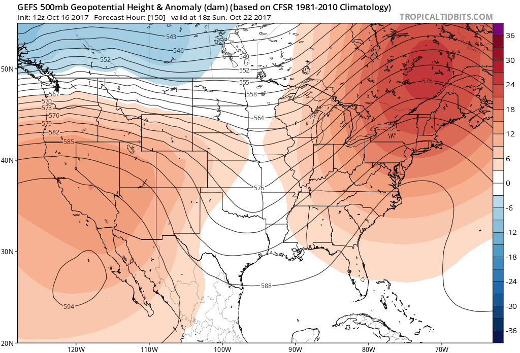
Sunday 22nd
[/span6][span6]
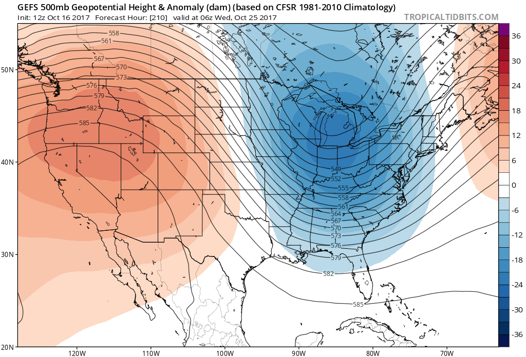
October 25
[/span6][/columns]
There is a hint of snow for Michigan but I think this system will bring a nasty cold drizzle, rain, snow mix with lake effect rain/snow later in the week. The GFS has six inches of snow next week for Wisconsin. Halloween looks to be slightly moderating towards normal for this time of year and into the first week of November. We should see our first wide-spread frost next week. Beyond the next two weeks is still up in the air (meteorology pun) – we are not sure if this is the flip we have been waiting for or it is just going to be a fluke.
I had expectations the flip would happen closer to Thanksgiving but it is not unheard of to see snowflakes in late October or even a good snowstorm as seen in the historical weather write-up above.. I think we will have a better idea if the new pattern will hold up beyond the first week of November by Halloween….
Enjoy this week because it may be the last time we see the 70s for quite a while (the normal temp for this time of year is around 60). Temperatures next week will fall into the 50s (and maybe some upper 40’s) for day time highs with frost and maybe some snowflakes. The first week of November may see even cooler temperatures as the cold air settles into place.
A large area of high pressure over the Central Appalachians will remain nearly stationary over the next couple of days. This fair weather system will lead to dry weather here in Lower Michigan. Conditions will be breezy at times with a moderating trend to the temperatures through Wednesday. The next chance of rain will be Sunday, next week appears to be wetter with perhaps another inch or better of rainfall.
INDY is thinking over a 100 inches of snow this winter season for west Michigan.. I have canned 24 jars of hot salsa out at thee YARDofBRICKS for this winter.. can’t wait .. INDY!
Tomorrow I will have the CFSv2 Winter Forecast which I will take into account in my own forecast next month.
Brett Anderson over at AccuWeather has his Canadan winter guess out and while the maps only cover Canada but if you follow the lines into the US it looks like (according to Brett) that the Great Lakes area (Michigan. Wisconsin, norther Indiana and norther Illinois would have a chance of colder and snowier then average winter) And while this would be to the north and east of Michigan he (Brett Anderson) writes “ –It will be a cloudier winter near and downwind of the abnormally warm Great Lakes. This should also promote significant lake-effect snowfall events, especially for cities such… Read more »
Does getting cold and snow in October lead to a cold and snowy winter? Well in looking at the past with snow and cold in the 3rd week of October (see Michael’s post above) 1943/44 seasonal snow fall at Grand Rapids 35.7” 1944/45 53.0” 1952/53 39.7” 1972/73 65.5” 1974/75 68.9” with 9” November,12” March and 10’ in April. 1989/90 89.8” (not much in January with bare ground much of the month) 1992/93 65.3” 2002/03 88.0” So in the noted winters after a October snow fall in Michigan Grand Rapids only had two winters where the snow fall was above and… Read more »