Yesterday wasn’t the most pleasant of days with rain, drizzle and a mix of wet snow at times. The precip amounted to .24 of an inch in Otsego which brings us to .34 of an inch for December. Our temp at 6 am is 38° down from 41° at midnight. It will be downhill from here as the winds pick up from the west bringing snow and blowing snow. Wind gusts will pick up to 45 mph dropping wind chills into the teens. Most of the snow will be along and west of the 131 corridor. Not expecting more than a couple of inches from this event.
 Hazardous Weather Outlook
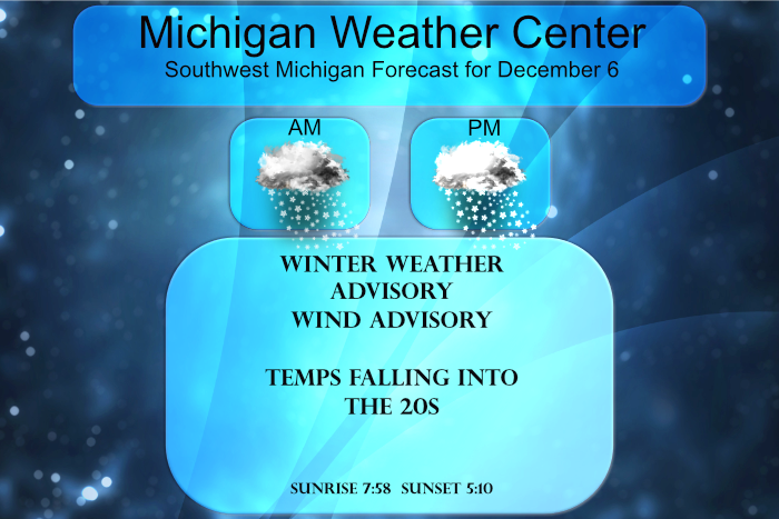
Strong cold air advection will cause gusty winds upwards of 45 to50 mph and lake-enhanced snow showers today. The strongest winds will be this afternoon. The biggest areas of concern for snow will be north of Big Rapids and south of Grand Rapids along the US 131 corridor. The biggest impacts of this event will be the strong wind gusts coupled with the lake effect snow showers that will cause near whiteout conditions at times late this morning through the first half of this afternoon. Power outages are possible from the strong gusty winds.
Temperatures will plunge into the 20s during the afternoon behind the front. Wind chills will fall below 10 degrees Monday evening.
Forecast Discussion
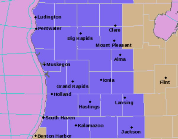
- Lake effect snow with Gusty Winds -

Strong cold air advection will cause gusty winds upwards of 45 to
50 mph and lake enhanced snow showers today. The strongest winds
will be this afternoon. The biggest area of concern for snow will
be along the US 131 corridor. Due to this a Winter weather
advisory will be in effect from 7 AM to 10 PM. The biggest impacts
with this event will be the strong wind gusts coupled with the
lake effect snow showers that will cause near whiteout conditions
at times late this morning through the first half of this
afternoon. Power outages are possible from the strong gusty winds.

A deepening upper level trough currently moving through Wisconsin
will excite the lake and then traverse Michigan this morning.
This corresponds with a cold front that will drop across the
region. Temperatures on the windward side of the lake are already
dropping to and below freezing. Latest NAM has 850mb temps
dropping to -10C by 15Z in Western Michigan. That cold air
advection and the corresponding front will provide steep lapse
rates in the 6 to 8C/km in the DGZ which will be strongest from
15Z to 21Z Tuesday. The gusty winds will only further fuel snow
generation and coupled with this will be areas of high Omega along
the lakeshore that given the strong winds will infiltrate one to
two counties inland. That infiltration will allow for areas of one
to three inches widespread and two to four inches possible. There
are two areas of most concern for snowfall totals, one north of
Big Rapids along the US 10 corridor and the other from Douglas
eastward into Barry county.

The highest winds will be Monday afternoon. That wind is one of
the biggest concerns with this system. There is strong upper
level winds that will have little directional shear from 750mb
below this afternoon. That will allow for strong gusty winds at
the sfc that could exceed 45 mph at times.

The winds will slacken early evening but will remain gusty
overnight into Tuesday. So while, snow generation will be
strongest in the afternoon, snow remains possible into Tuesday,
though amounts at that time will be lighter.

The thermal trough will move quickly eastward so driving
conditions will improve a bit during the evening despite cold
temperatures with a reduction in snow and blowing snow.

- Several upcoming chances for snow -

While the trend for snow Tuesday night into Wednesday continues to
decrease, there remains the opportunity for snow in the Ludington
region early Wednesday morning as another narrow band of
instability moves through. While that is much shallower and
further northward, there remains another chance for snow along
the US 10 corridor.

Following that there will be a negatively tilted shortwave with
warm air advection that could bring mixed precipitation Thursday
night into Friday. Another storm system is on the horizon Friday
into Saturday.
What a storm. We have been getting pounded with snow all day! Already up
To 2 inches and counting! Incredible!
We are at inch or so also hard to measure the wind keeps blowing but definitely adding more and more inches to the above average snowfall that once was nevee supposed to happen lol…InDY
29* degrees out in my hood cold put another log on the fire baby …InDY
The CPC’s long range guess shows a very mild pattern for mid December. So this cool down looks to be brief.
Slim
Sure looks that way!
https://weather.com/weather/tenday/l/b4ea0280869baa46799dc75eacef8904785ec43ad2f6fb098355fbc208a55e2c
I hace to say the CPC has been wrong since October time will tell the GFS modle shows no warm up in sight actually around the 20th a big cool down and sofar anything warm has been short lived with a cold front..InDY…
Wow!!! They had to come up with new shades of red for how much above normal it’s going to be for weeks!!! Keep the warm December ROCKIN!!

There you go again wasting our time!
There have been off and on snow showers today Here at my house the ground is covered but I was on the south side of town and there is no snow on the ground there. Here it is some what windy with the on and off snow showers at the current temperature here is 32.
Slim
We getting absolutely pummeled with snow! What a great winter day!
The above average snowfall keeps adding up for this young Wimter season and yes everyone in west Michigan is getting snow today incredible….InDY
Yes and this despite the constant warm weather hype and that winter is warmer than normal and less snow! Of course the opposite is true!
Gone fishing again lol…InDY
This week has the earliest sunsets of the year. We start to gain seconds later this week and 1-2 minutes next week. Then we have a good 6.5 months of increasing light in the evenings 😀
Decided it was time to put my snow tires on today. Bridgestone Blizzaks are great.
This would have been was what was called a Travelers Advisory back in the day. I wish they still had something like that – something just to warn drivers of potential poor road conditions.
The temps look to be in the upper 40s by the end of the week. Makes one wonder if we will have a white Christmas. I hope so.
Lake effect snows and gusty winds with temps in the 20″s who knew?? Its the most wonderful time of the year ….InDY
Great winter day! Hopefully many to come!
Another WWA has been issued! This is our 4th one already! What a great start to winter! This is absolutely incredible! Keep it rocking!