Congrats to the Wolverines for winning the Big 10 conference last night 42 to 3, being a Wolverine fan for many, many years I am smiling with happiness. These guys are awesome.
Yesterday we had a high temp of 41.5° and a low of 29°.
 After a sunny day yesterday things will take a turn for the worse today through tomorrow. Sunday afternoon and evening will feature rain and a chance of lightning in Southern Michigan, an icy mix possible in Central Michigan, and snow farther north. Temperatures will stay relatively mild Sunday night, then drop on Monday amid gusty winds and snow showers. Travel conditions around Michigan will be a challenge on Sunday and Monday, and scattered power outages are also possible.
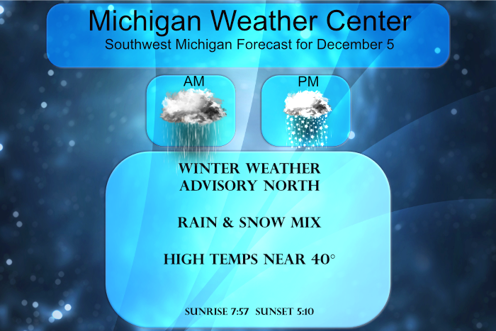
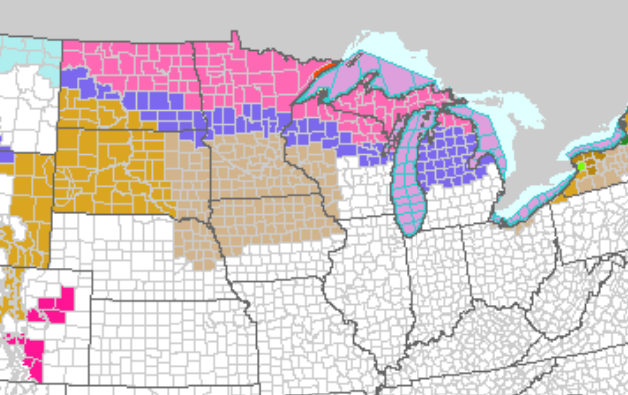
There is a winter storm warning for the U.P. and the northern lower counties (the areas in pink). The winter weather advisory covers central Michigan (counties in blue). The warning area could see 6 to 10 inches of snow through tomorrow).
A wintry mix of precipitation is expected this afternoon and evening across Central Lower Michigan, or essentially for areas north of a Muskegon to Cedar Springs to St. Johns line. Snow of 1 to 3 inches is possible along with sleet and freezing rain. Icing of a tenth of an inch is possible. Winds will increase significantly late tonight and on Monday with gusts in excess of 45 mph possible in most areas. Winds may gust above 50 mph in the lakeshore counties. Wind-driven lake effect snow showers are expected on Monday as well, with additional accumulations of an inch or two possible. The highest snow totals around 3 inches are possible from Big Rapids to Cadillac on Monday.
Forecast Discussion
- Winds and Mixed Precipitation Today -

It will be a brisk day today with southeast winds of 15 to 30 mph
with max gusts between 30 and 40 mph. We are not expecting wind
advisory gusts (over 45 mph) given the clouds that will limit
mixing and precipitation moving in.

Precipitation is already occurring in east central Wisconsin at
Oshkosh. High resolution models advect this precipitation into
Western Lower Michigan late this morning. The precipitation starts
in earnest though early this afternoon. Model soundings support a
mix of precipitation across Central Lower Michigan where a warm
nose of air surges in over the top of a retreating low level
colder air mass. The result will be a mix of snow, sleet and
freezing rain as the precipitation works towards the east. The
time frame of concern is from 1000am through 1000pm today. We have
issued a Winter Weather Advisory during this time frame from
Muskegon, Montcalm and Gratiot counties to the north. The heaviest
and most impactful precipitation will move through this afternoon
and early evening. We are expecting a 1 to 3 inch snowfall across
these counties with the highest amounts occurring in the far
northeast from Reed City over to Harrison and Clare. To the south
there will be more in the way of sleet and freezing rain mixing
in, especially along M-20 and M-46. We could be looking at a tenth
or so of icing in the heaviest corridor of freezing rain. So
nothing too significant, but it does not take much in the way of
freezing rain to cause issues. The precipitation should move off
to the north and east during the mid to late evening hours, with
precipitation ending and temperatures warming above freezing in
all areas.

We are expecting rain across the southern half of the forecast
area or roughly I-96 to the south. Cannot rule out a rumble of
thunder or two, but in the grand scheme of things this will be
rather insignificant. If a thunderstorm does occur it will be
this evening towards the MI/IN line. The SPC HREF essentially
brings no CAPE into our CWA. Deterministic models bring 200 j/kg
or less of MUCAPE into the far south.

- Winds and Lake Effect Snow late tonight and Monday -

Winds will ramp up after 500am in the morning and continue right
through the bulk of the day on Monday. The most significant gusts
look to occur in the cold air advection directly behind the cold
front between 600am and Noon. Both the ECMWF and HRRR are
indicating Wind Advisory worthy gusts (45+ mph) over the bulk of
the forecast area. In addition, at least portions of the
lakeshore may see a High Wind Warning level gust or two (58+ mph).
At this point will hold off on and wind headlines for now and will
message it in social media posts and the HWO.

Complicating headline decisions for Monday will be a surge in lake
effect snow. Lake effect snow will begin near or just before
daybreak on Monday, persisting through the day and into Monday
night. The most significant snow will likely occur with the
deepest moisture on Monday. We could see a few spots reach 1-3
inch accumulations in strong westerly flow. Given the strong
winds, the better accumulations will likely be displaced inland
towards Highway 131. Best chances at 1-3 inch accums will be north
of GRR towards Big Rapids and Cadillac. We will likely make
headline decisions for Monday at some point today or this evening.
It would be a messy headline scenario with multiple Winter Weather
Advisories out so decided to hold off. The Monday threat is multi
faceted with both wind and snow being a concern. Temperatures at
best on Monday will be near the freezing mark, so some travel
concerns will exist.

- Several More Chances for Precipitation in the 7day Forecast -

Lake effect snow will likely continue to some extent into Tuesday
but it should effectively be squashed by high pressure sliding in
from the west.

The Tuesday night precipitation has backed off quite a bit in the
models with the next good chances coming Thursday and again Friday
night. The Thursday precipitation will be along a trough sweeping
through and the Friday night event will be northwest of a low
trekking through the Central Great Lakes towards Lake Erie. It
will not be cold enough for all snow with each event so rain/snow
is in the forecast for both periods.
If you like COLD, SNOW, and WIND you are going to love tomorrow! Incredible winter weather! The snow just keeps coming!
Getting sluchy out Lachine, Michigan. Already 3 to 4 inches Posen, Michigan.
Raining at pretty good clip here and washing the road grime away.
There looks to be rather heavy snow falling at this time in Houghton Michigan.
https://www.mtu.edu/webcams/view/
And there looks to be a good amount of snow on the ground in the Gaylord area at this time.
http://www.snowmancam.com/
Slim
Some slippery spots developing. My car is also coated in a layer of ice. I am not sure to what extent how bad the driving is, but definitely at least some areas of ice. We are still only 32 degrees so currently freezing rain.
There is a good trace amount of snow on the ground and at this time getting freezing rain and sleet here with a temperature of 31. Roads are mostly wet with some icy spots more so in parking lots.
Slim
37 and cloudy here. No precip yet.
Pretty sloppy out right now. Looks like roads are still just wet atm
Nice wintry week of weather is headed our way! Bring it on! COLD, WIND, temps in the TEENs and 20’s, lake effect snow, and sleet! Incredible!
First off congrats to Michigan and their big win over Iowa last night! The overnight low here was 28 and with cloudy skies it is now 31. Yesterday the official high at GRR was 41 with a lot of sunshine before the clouds moved in. The first 4 days of December have been very mild and the departure for the month is now at +3.8 and so far just 0.6″ of snow fall.
Slim
U of M looks as good as ever! Great season and I will give Harbaugh some credit for finally winning some big games!
I went to MSU but I generally root for both teams. Always good to see a team from Michigan win!