Yesterday was a miserable day in SW Michigan for those who had to be outside. I was out early yesterday morning in the cold rain and slush sawing up a tree that fell across the road and my neighbor’s driveway – not a fun job. We had three inches of snow which has mainly melted off getting ready for any accumulation coming for today. Yesterday’s high was 39° the low was 32°. Liquid precip with melted snow was .75 of an inch bringing us to .99 for the month and 8.99 for the season.
[columns] [span6]
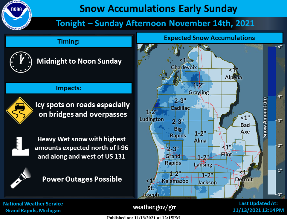
The heaviest snow will be early Sunday morning until mid to late morning hours. Snow will be heavy and wet with the highest amounts expected north of Grand Rapids and along and west of US-131, especially in the Ludington region. The heavy wet snow could bring down power lines and make power outages possible.
[/span6][span6]
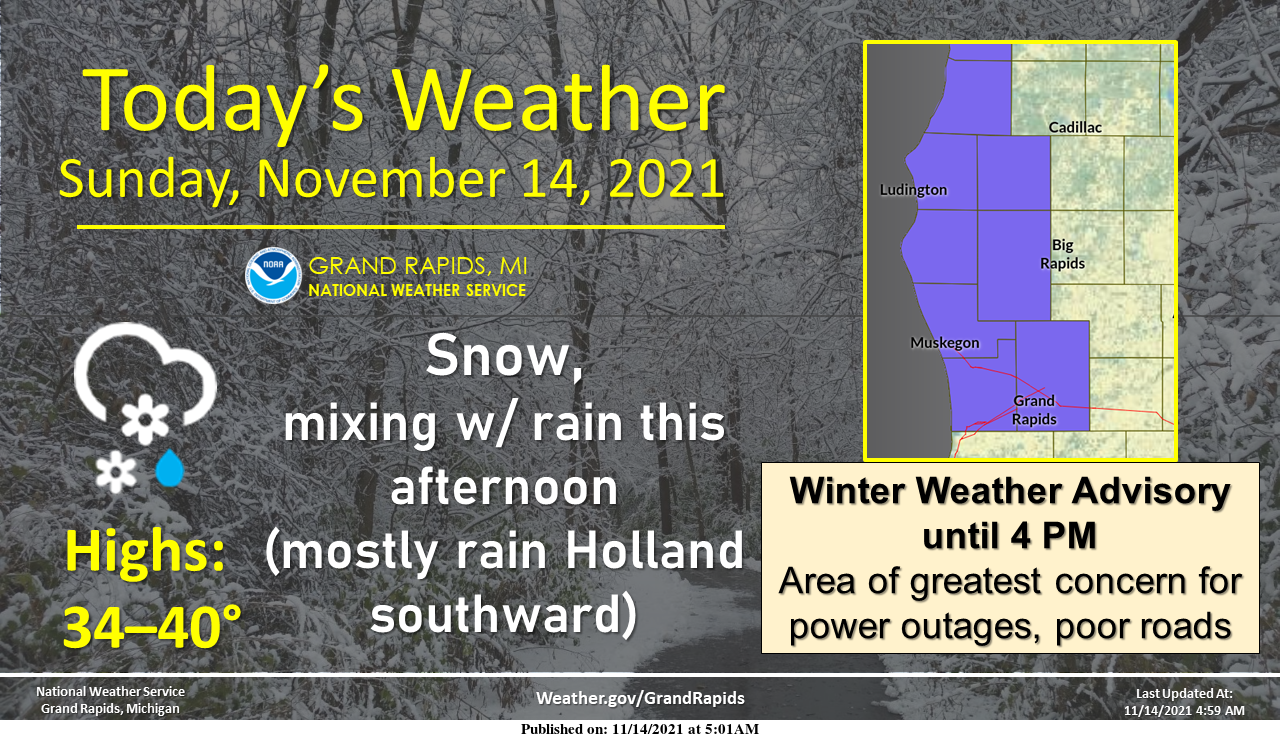
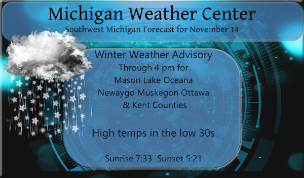
Widespread snow will develop today, mixing with rain this afternoon. However, lakeshore areas south of Holland will see mainly rain. A Winter Weather Advisory is in effect for some counties until 4 PM (see map). This is the area of greatest concern for a few power outages and poor road conditions as heavy wet snow accumulates.
[/span6][/columns]
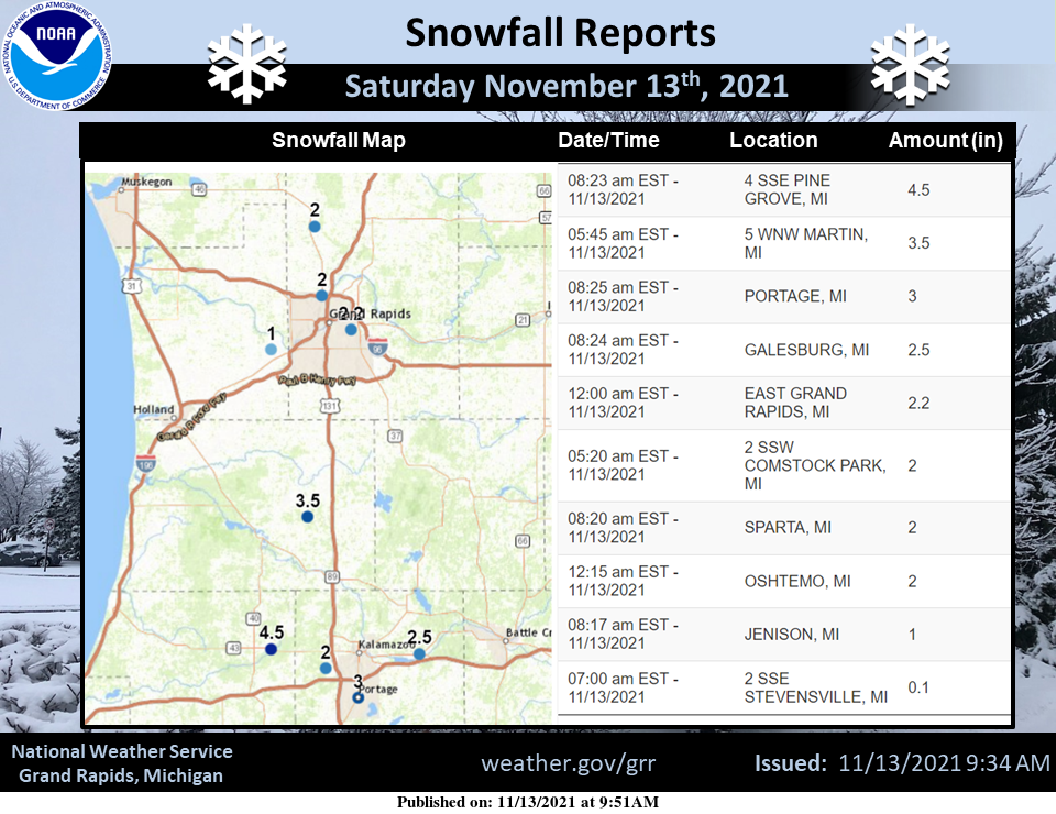
These are the snowfall totals from yesterday:
Forecast Discussion
-Clipper System Brings Winter Impacts Today

Compact vorticity maxima/clipper system seen in water vapor
imagery near Minneapolis tracks southeast toward Detroit today.
Relatively narrow swath of synoptic QPF of around a third of an
inch is expected to fall along and just north of the track of the
vort, but southwest flow enhancement off Lake MI provides a
significant boost.

The localized probability matched mean QPF from the 00Z HREF
actually shows over one inch of total QPF around Muskegon where
low level convergence is maxed out this morning. This is also
where the productive srn edge of the synoptic deformation zone
sets up this morning.

For now we are inclined to stay the course with our current
Winter Weather Advisory with 1-3" being the most likely outcome,
but there`s a chance it could bust on either end of the spectrum.

A mostly snow scenario where locally higher model QPFs are
realized could bring warning criteria snow of up to 7" and
significant travel impacts, whereas the more likely rain/snow mix
scenario with sfc temps above freezing and results in only
limited impacts.

Many trees still have not shed all their leaves and the weight of
heavy wet snow could take down limbs and power lines. We already
saw this occur early Saturday morning from only 3-4" of lake
effect snow near AZO.

Typically in early season events topography plays a role in rain
vs snow and accumulations. The higher elevations north of GRR
and inland from Lk MI such as White Cloud and Baldwin, as well
over the Irish Hills over s cntl Lwr MI (JXN), stand the better
chance of seeing more snow than rain today.

Period of NW flow lake effect occurs on the back side of this
system later today/this evening, although this looks to be a
rain/snow mix due to warmth coming in off the lake, so any
additional lake effect accumulations/impacts should be limited.

-Not as active (or as cold) after today

Pattern turns less active/warmer for the coming week as cold upper
trough lifts out. In fact a big surge of warm advection mid week
could deliver highs up near 60 again on Wednesday before next cool
down sweeps in behind a cold front on Wed night. Looks like a
good chance of rain showers along that front at this point.
Breaking News >>>>>> the weather in Pittsburg was similar to here and the LIONS are now undefeated the last 2 weeks? Incredible!
While there was a solid trace of snow on the ground this morning that is now all gone. Today was a cold and damp day with a light rain/snow mix. The high here for the day so far was 37 and at this time there is a snow/rain mix with a temperature of 36.
Slim
Snow is mostly melted, we probably got 2-3 inches the other day. Looks like a chance for snow on Thursday.
We got hammered with snow this AM. It was a great sight! This is just a sign of things to come. We will be seeing multiple WSW and WWA this winter! I love it!
We received a little snow, but nothing to write home about. The grass has some white, but nothing on the driveway or street.
We went out to build snowmen with about the same amount of snow you picked up Michael. We were without power for 20 hrs. came on early this morning. Thank goodness for a generator. Weird thing my friends were without power the same as us, but their neighbors had power.
This morning there is light snow falling but with a temperature of 33 there is just a trace of snow on the ground so far here. As this area is in a WWA I guess it is the curse of the WWA.
Slim