First I have to mention my wife and I celebrate our 25th anniversary today and a special thanks to her for tolerating me all these years. The day we were married we were having snow squalls blowing and picked up six inches of lake effect snow.
February Summary
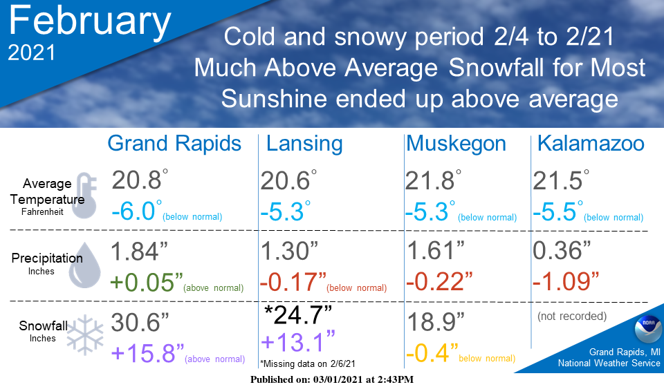
February 2021 was an interesting month that ended up colder and snowier than average overall. The period from February 4 to February 21 was the coldest and snowiest period. The rest of the month was actually mild with generally above-average sunshine.
Met Winter Summary
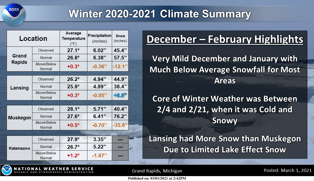
The winter (Dec-Feb) of ’20-’21 had near to slightly above average temps, while snow ranged from much below average near the lake to above-average toward Lansing. Much of the winter was mild, except for a cold period from February 4 to February 21. Much of the season’s snow came during that period.
For some reason, Kalamazoo doesn’t track snowfall amounts or averages. That said we once again lacked the lake effect snows which usually define our winter. With an NW wind, we used to get copious amounts of snow in the M40/M89 corridor from Holland to Kalamazoo. Back in the day when driving from Holland to Plainwell we would see heavy snow and blowing snow up to US131 where there would be light snow showers and some sun.
Forecast Discussion
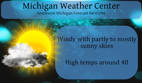
-- Mainly Dry 7 Day Forecast --

A mainly dry forecast is expected the next 7 days. The very small
opportunities for any precipitation would come in a few places
within the forecast. The first being tonight into Wednesday with
a cold front dropping south through the area. The front is
moisture starved and we expected it to come through dry. The next
chance would be Friday night into Saturday with a weak shortwave
dropping southeast through the Great Lakes. Again, moisture is
limited and we expect no precipitation at this time. The final
opportunity is out at the end of the forecast period Sunday night
into Monday night. The operational GFS and ECMWF have timing
differences with a wave moving through the area. This is not
surprising 6-7 days into the forecast. The precipitation looks
fairly light. Would tend to lean toward the slower ECWMF here
which would bring a small chance for rain next Monday night.
Bottom line is pretty much a dry forecast through the upcoming
weekend.

-- Seasonable Temperatures into the Weekend --

Temperatures through the next 7 days look to be at least
seasonable if not above normal. 850mb temperatures are on the
order of -7C to +3C which is pretty close to what you would expect
over the Great Lakes this time of year. This should result in
quite a bit of high temperatures in the 40s through the weekend.
We will be warm enough aloft to keep lake stratocumulus at bay, so
we should see quite a bit of sunshine. We have eroded much of the
snow cover across the area, especially from I-96 to the south. We
will continue to erode snow pack, river ice and lake ice as we
move forward. The warming temperatures and increasing sun angle
should even begin to erode the large snow piles around the area in
the coming 7-10 days.

-- Possible Pattern Change Early Next Week --

It appears as though deep southwesterly flow begins to take shape
early next week, stretching into mid next week as well. Early next
week 50s look very reasonable with the gulf opening up. Any
remaining snow will really be on the melt given those
temperatures. Next Tuesday and Wednesday, PWAT values increasing
to around 1.25 inches. Surface dew points may eclipse 50F. Even if
it ends up being a decent rain event next week with a low moving
through the area, much of the snow and ice will be gone so we are
not expecting major impacts or issues at this point.
Wow we plowed 13 Times
This year, every year it gets less and less snowplows will be a thing of the past in a couple years!!!
Low of 11* degrees overnight in my area I haft to say that’s. Pretty darn cold for March standers wow …INDY
And yet 20 degrees away from even tying the record low for today.
And Probably 55* degrees In zland with light rain showers right??? LOL …INDY
How is it going to rain when there’s not a cloud in the sky? Beautiful out today. What happened to your non stop snow till May? Just a bit of with that wishcast.
Pretty amazing as I look outside and still see snow coverd grounds in my area as of March 2nd Christmas day we had snow on the ground also it hasn’t all gone away since then that’s a long time ago shuuuuu….INDY
That’s funny because NWS GRR has reported many days in that time frame with absolutely no snow on the ground. I love short winters!
Wow, that forecast is amazing for the beginning of March. WOOD has 40’s and 50’s as far as the eye can see! And the CPC has us in an early spring blowtorch.
Poor Bill Steffen looked so sad on the news last night. We will call this year the 2 week winter.
I really don’t think Bill steffens is poor, He’s a chief meteorologist for a reason last I checked LOL!! INDY
Matter of fact Bill Stephens is a walking dictionary the guy is amazingly smart he’d run smart weather laps around you at his age no joke LOL ….INDY
I’m sure he is. But he sure does love his cold and snow, and I believe he thinks climate change is a myth. Didn’t WOOD predict like 70″ of snow this winter?
IN BILL STEFFENS WE TRUST!! INDY!!
So yet another Met Winter with well below average snow. It has been very strange the past several years now with almost no lake effect snows. And the real oddity is Lansing having more snow than Muskegon. I would think that does not happen very often. Prob a Slim question…..
Happy anniversary MV! 25 years is a great one to reach! Just had ours 2 years ago.
I also wish you a Happy Anniversary today! I know it takes lots of effort to stay together (I celebrate my 25th this year as well) this long, truly a journey with good times and bad along the way, but, I feel, worth every gray hair and smile crease!
Checking out the models around the 17th 18th of March a pretty good cold snap is possible could it be a artic blast?? Showing up with yes snow I wouldn’t plant any flowers just yet! We definitely could be in for a cooler second half of March stay tuned …INDY
Sounds great and keep the reality facts rocking!
Here is some more information on this past met winter. The average H/L at GRR was 33.3/21.0. The 30 year average is 33.1/20.5. For the season there were 0 thunderstorm days. 1 day with heavy rain, 17 with light rain, 51 days with light snow 3 days with heavy snow. There was 27% pf possible sunshine with 7 clear days, 17 partly cloudy days and 66 cloudy days.
Slim
So we ended up being warm after all? I love it!
Happy anniversary! The current temperature here at my house is 12.4 I wonder it this will be the last very cold morning this season.
Slim