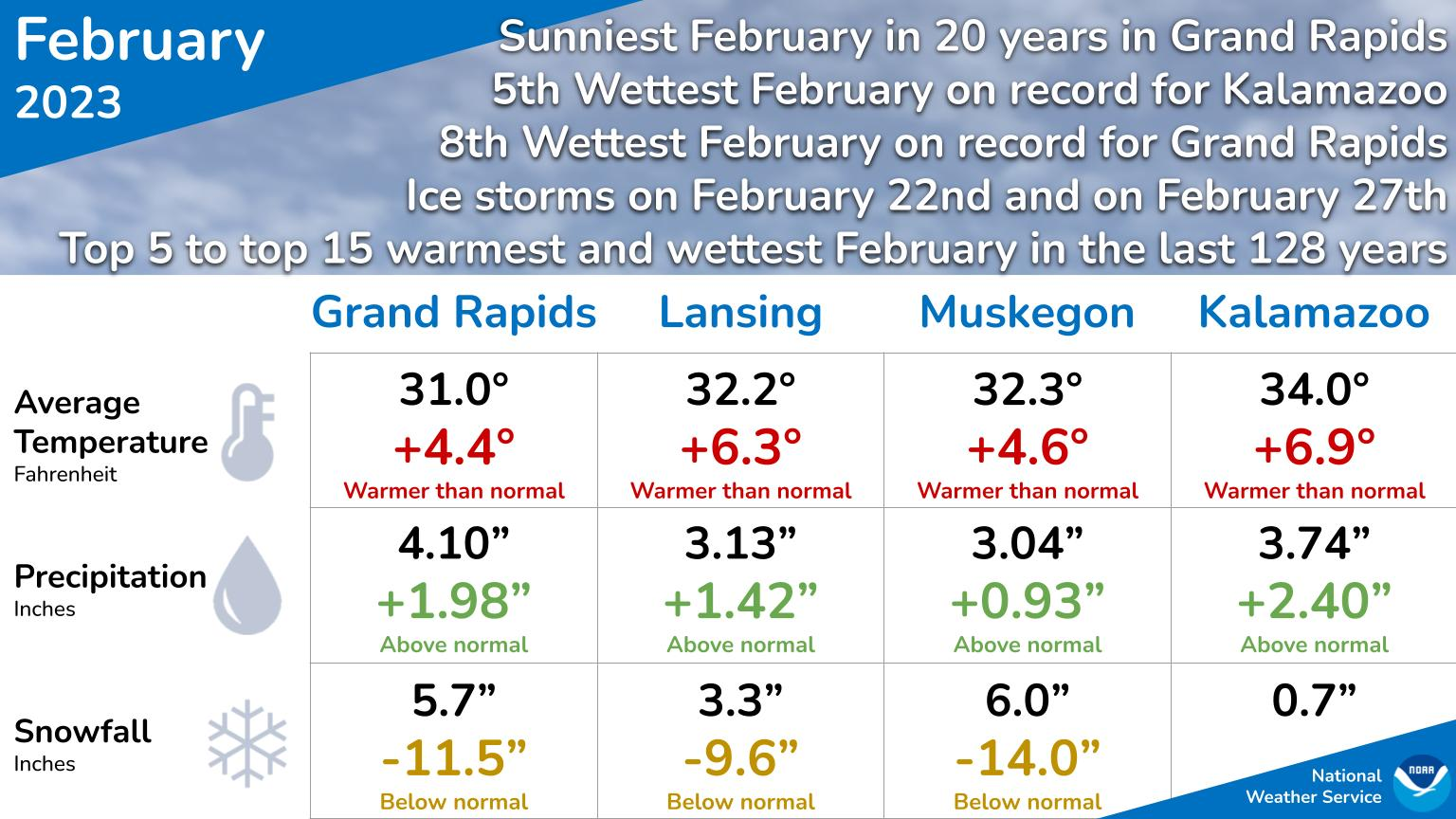
February was sunnier and warmer than normal with more rain and less snow.
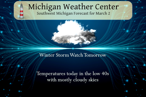
Yesterday we reached a very nice 56° with partly cloudy skies in Otsego. Today will be the calm before the storm. A storm system will move into Lower Michigan for Friday, bringing primarily snow but some light freezing rain could mix in across the far south. Several inches of wet snow is likely. This will impact the Friday evening commute with delayed travel likely. Otsego’s point forecast snow is 5.6 inches between 1 to 7 pm.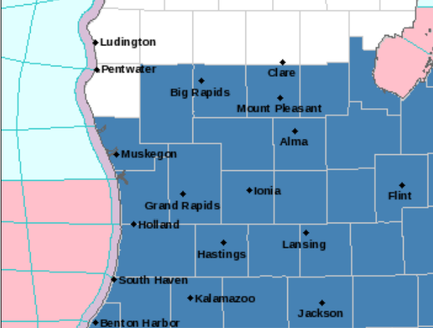
...WINTER STORM WATCH IN EFFECT FROM FRIDAY AFTERNOON THROUGH
LATE FRIDAY NIGHT...

* WHAT...Heavy snow possible. Total snow accumulations of 6 or
  more inches possible. Winds could gust as high as 40 mph.

* WHERE...Portions of south central and southwest Michigan.

* WHEN...From Friday afternoon through late Friday night.

* IMPACTS...Travel could be very difficult. The hazardous
  conditions could impact the evening commute.

* ADDITIONAL DETAILS...Wet, heavy snow is expected, with snowfall
  rates of 1 inch per hour possible. Slippery, snow-covered roads
  are possible, and may greatly impact the Friday afternoon and
  evening commute. Hazardous travel conditions may persist into
  Saturday.
Grand Rapids Forecast
3 2 grrLansing Forecast
3 2 lanKalamazoo Forecast
3 2 kzoForecast Discussion
-- This morning --

GOES water-vapor imagery shows a midlevel shortwave trough / vort
max progressing through the northern Great Lakes early Thu morning.
Lift ahead of this feature is supporting rain and snow showers over
northern/central counties this morning. Some light slushy
accumulations are possible mainly east of US-131, where subfreezing
wet-bulb temps are present at the surface.

-- Impactful System on Fri --

A potent mid/upper low over AZ will emerge into the Southern Plains
this evening. Upper divergence in advance of this feature will
foster cyclogenesis along a baroclinic zone in the Southern Plains
today, with a surface low reaching northeast TX this evening. This
low will advance toward the region tonight/Fri, likely reaching the
vicinity of western Lake Erie on Fri evening/night. Strong northward
moisture transport will occur within the expansive cyclone warm
sector, with PW anomalies reaching 3-4 standard deviations above
climo means. Robust deepening of the cyclone on Thu night and Fri
morning will be aided by a coupled upper jet structure, consisting
of (1) a northeastward advancing 130-kt speed max over TX and the
Lower MS Valley, and (2) a downstream, anticyclonically curved jet
axis over the Great Lakes and New England along the northern
periphery of an amplifying upper ridge. As this deepening
progresses, models suggest that a characteristic upper-level PV hook
structure will develop in conjunction with the emerging warm
occlusion in the midlevels. Strong QG forcing for ascent within the
cyclone comma-head region will result in precip over most of the
forecast area between Fri afternoon and night, and confidence is
high that a sizable portion of the forecast area will see
appreciable snowfall during this period.

Some uncertainty remains regarding the location of the axis of
heaviest snowfall. Because of this positional uncertainty, the
ensemble spread in snowfall amounts (i.e., the range of plausible
amounts) remains large in some locations. Regarding trends in recent
ensemble guidance, the axes of heaviest ensemble-median snowfall
(using 10:1 SLR) in the EPS and GEFS have broadly shifted toward one
another in recent runs, a step toward improved ensemble consensus.
Additionally, median snowfall amounts along these axes have
generally trended higher; EPS-median amounts in the latest (00z) run
are around 11" (again w/10:1 SLR) along an axis from Holland-GR-
Alma, with lower amounts off this axis.

Model profiles exhibit a somewhat shallow (~5 kft) DGZ centered near
15 kft AGL, with the DGZ generally collocated with weak moist
static stability. Beneath the DGZ, profiles show a deep (5-10
kft), saturated, and approximately isothermal layer with temps of
-10 to 0C. This layer will favor efficient crystal growth via
aggregation (large, fluffy clumps). SLR guidance favors reduced
ratios (6-9:1) on Fri afternoon with marginal surface temps, then
higher ratios (10-13:1) as temps cool into Fri evening. Obviously,
given high QPF values, the snowfall forecast is quite sensitive
to SLR.

Fortunately, the risk of freezing rain and sleet appears to have
lowered in recent model runs, as suggested by thermal profiles and
objective precip-type diagnostics. Overall, recent ECMWF and GFS
deterministic solutions have trended toward predominately snow
across the forecast area, although a rain/snow line may be a factor
across southeast counties.

EPS-mean wind gusts have lowered somewhat in recent runs, with 35-40
mph gusts mainly across the southern forecast area from late Fri
afternoon into evening. Fortunately, this would reduce the
risk/extent of any power outages. Blowing snow is possible, but the
expectation of wet/sticky snow should mitigate the extent of blowing
snow overall.

After coordination with WPC and adjacent offices, a Winter Storm
Watch will be issued (info appended below; WSWGRR to follow
shortly). This watch will highlight the potential for 6"+ of
heavy/wet snow, with 1" per hr snowfall rates possible. The main
impact from this system still appears to be hazardous travel,
primarily from Fri afternoon into the night, with widespread
slippery/slushy roads expected.

-- Periods of snow/rain likely from Sun night into Mon night --

Global models suggest that a lee cyclone will develop over the CO
plains on Sun, then approach the region on Mon. Precip appears
likely during this period, perhaps from one or more rounds. Thermal
profiles suggest a possible rain/snow delineation across the area.
In looking at the NAM, HRRR, and Euro they are fairly close in terms of track. The Euro has nudged slightly back north. Overall at this stage I’d say the headlines look pretty good. Will re check things around daybreak.
I do not like the current model trends, however the latest RDB still gives GR 3-6 inches of snow! Stay tuned for the update tomorrow morning! I love long winters!
Interesting to note the HRRR and NAM are pretty close in line with each other and the Euro has nudged slightly back north
Winter Weather Advisory URGENT – WINTER WEATHER MESSAGE National Weather Service Grand Rapids MI 946 PM EST Thu Mar 2 2023 MIZ045-046-051-052-056-057-031100- /O.UPG.KGRR.WS.A.0002.230303T2000Z-230304T0700Z/ /O.NEW.KGRR.WW.Y.0011.230303T1900Z-230304T0900Z/ Mecosta-Isabella-Montcalm-Gratiot-Ottawa-Kent- Including the cities of Big Rapids, Mount Pleasant, Greenville, Alma, Grand Haven, Jenison, and Grand Rapids 946 PM EST Thu Mar 2 2023 …WINTER WEATHER ADVISORY IN EFFECT FROM 2 PM FRIDAY TO 4 AM EST SATURDAY… * WHAT…Snow expected. Total snow accumulations of 2 to 5 inches. Winds gusting as high as 35 mph. * WHERE…Mecosta, Isabella, Montcalm, Gratiot, Ottawa and Kent counties. * WHEN…From 2 PM Friday to 4 AM EST Saturday. *… Read more »
No surprise because most of the models have trended the heavier snow south and East of GR! Still time to move North however!
URGENT – WINTER WEATHER MESSAGE National Weather Service Grand Rapids MI 946 PM EST Thu Mar 2 2023 MIZ064>067-071>074-031100- /O.UPG.KGRR.WS.A.0002.230303T1700Z-230304T0700Z/ /O.NEW.KGRR.WS.W.0003.230303T1900Z-230304T0900Z/ Allegan-Barry-Eaton-Ingham-Van Buren-Kalamazoo-Calhoun-Jackson- Including the cities of Holland, Hastings, Charlotte, Lansing, South Haven, Kalamazoo, Battle Creek, and Jackson 946 PM EST Thu Mar 2 2023 …WINTER STORM WARNING IN EFFECT FROM 2 PM FRIDAY TO 4 AM EST SATURDAY… * WHAT…Heavy snow expected. Total snow accumulations greater than 6 inches likely. Snowfall rates greater than 1 inch per hour possible. Winds gusting as high as 35 mph. * WHERE…Portions of south central and southwest Michigan. * WHEN…From 2 PM Friday… Read more »
Winter Storm Warning for the south end of Lake Michigan (NE IL, NW IN) for 4-8” of snow.
Too funny – Accuweather has GR picking up 12 to 18 inches of snow! John Dee says 8 to 12 inches! What the heck! It looks the GFS has been pretty consistent with the heaviest snow SE of GR and EURO has not been consistent at all! Wow to the wow!
To put it simply and honestly, this forecast is a challenging one. Even with the ever shortening lead time, many model solutions are in significant disagreement on where the main swath of heavy snow will develop. While previous model information placed the best probabilities of heavy snow along a line from Grand Rapids to Saginaw, today’s model trends have shifted the heavier swath of snow further southeast towards the I-69 and I-94 corridors. Where the heavy swath of snow does develop, snow amounts of 6 inches or greater will be possible. Some areas may even see up to 10 inches… Read more »
You know all of us will be checking the latest as soon as we roll out of bed.
Watching Ryan Hall y’all lots of tornadoes in TX.
Watching The Weather Channel and there is a tornado warning for downtown Dallas currently
Both TV Mets said 4-8 here, 2-4 for GR. Forecasting the accumulation is a challenge because the snow will melt early during the event and it’s impossible to know when the snowfall will overcome the melting, and the snow will be so heavy and wet, it won’t get super deep and remain very compact.
Interesting. One outlet over here shows 6-12 for Lansing the other says 6-10 haha.
Wouldn’t be surprised to see more rain with all the rainy days and rain records we’ve had the past couple of months. And if we do get snow, just like all Winter it will quickly be gone with the weekend temps in the 40’s and near 50 on Monday.
“We will keep the winter storm watch going given the continued uncertainty of where the heaviest band of snow will set up. This uncertainty shows up in the ensemble forecasts from the ECMWF…GFS and CMC for Grand Rapids showing anywhere from 0 to 15 inches possible. The NAMNST/NAM models are showing the main band of snow near and northwest of Grand Rapids. The rest of the models are trending toward the heaviest snow falling southeast of a South Haven to Alma line. It is worth noting that surface temperatures will likely be in the mid to upper 30`s when the… Read more »
This is becoming almost comical (0-15″??). I don’t think I’ve ever seen the NWS GR so gun shy on a forecast. Just goes to show how dependent they are on the computer models.
Yea that is the most uncertain forecast I have ever seen for a winter storm just 20 hours out… I guess anything could happen. I’d prefer either 0″ or 10″+. Anything in between does not impress me anymore 😀
I found the 0-15” pretty funny as well. In other words anything could happen haha
The 12Z European is in and continues to show the heaviest snow SE of Grand Rapids. It prints out about 3-5” for the Grand Rapids metro area. Meanwhile over around Lansing and points SE it shows 10-12”. That’s at a 10:1 ratio. Not sure what is being used for this event. Matt Kirkwood at Noon said he thinks 3-4” for downtown GR at this stage
Midday forecast discussion from the Windy City. They acknowledge that even though they’re less than 24 hours away from the event, it’s still a head scratcher.
https://forecast.weather.gov/product.php?site=LOT&issuedby=LOT&product=AFD&format=CI&version=1&glossary=1
Noon TV met just said 4-8″ possible for Lansing, less to the north and northwest, and more (6-10) to south and southeast. He again stressed the disclaimer that the models are still not locked in yet, and the evening news should provide a more confident forecast.
Note, the low is still over Arizona/New Mexico. Think about it – it’s going travel some 1,800 miles in the next 30 or so hours. That in itself is amazing.
Wow
If that verifies that would be a monster storm!
Is this run from 3 days ago?
Looks like it. The current track from the ECMWF is quite a bit further SE
12Z GFS is in. Favors snow totals greater than 5” south of a line from South Haven to Saginaw. My greatest interest will be the 12Z Euro in a few hours. Tends to handle systems the best even though all have struggled with this one.
Next week looks cold as the cold air begins to filter into MI and this will last for weeks on end! Get prepared now!
I have to be in Warren over in Macomb County tomorrow around 10am. Probably not back home till evening. Should be an interesting ride.
The NAM shows rain and mixed precip coming way into Michigan, The HRRR completely misses GR. The GFS and Euro are closer together with minor differences. Bottom line I still don’t think anyone confidently knows how this one will shake out. Time will tell.
Interesting, because the HRRR is usually fairly accurate? Accu weather on the other hand gives GR about 12 inches of snow!
Unfortunately AccuWeather is not the most accurate (AccuLess) 😀
Agreed!
The Weather Channel gives GR 3 to 6 inches, so still a lot of uncertainty with the models and the different weather sources! It will be very interesting indeed!
WOOD now has 40-44 degrees Saturday, Sunday, and Monday. Looks like a pleasant weekend with lots of sun.
One thing to note about the cool weather the CPC is predicting for mid-month. Technically 39 is average for today (March 2) but around 5 degrees below average for March 15. It looks like most highs will be 34-44 for the first half of the month, so it isn’t indicating an arctic outbreak or anything. Just a continuation of the early March temps
Warmer spring temperatures can often be slow to arrive here in Michigan. So yes highs in the mid to upper 30’s are common in the 1st half of March. And it can still be cool even into late March and the start of April.
Slim
I noticed some of my spring showers are trying to pop up.
My sis said she is seeing some perennials starting to emerge from their winter slumber.
Stay tuned, the SSW event is still unfolding, so it is possible for the polar vortex to pay a visit and then those temps will be colder! Bring it!
Yesterday was a mild 1st day of March with an official H/L of 47/30 at Grand Rapids. There was a reported trace of snow fall and there was a trace of snow/ice on the ground. The sun was out 22% of the time. For today the average H/L is now up to 39/23 so highs of 40 or better are now common. The record high of 60 was set in 1931 and 1983 the record low of -8 was set in 1978. The biggest snow fall of 13.6” fell in 2002. Now all eyes will see how the Friday system… Read more »
Torregrossa’s morning take:
https://www.mlive.com/weather/2023/03/winter-storm-watch-posted-heavy-snow-for-all-of-michigans-biggest-cities.html
https://www.mlive.com/weather/2023/03/heavy-snow-becoming-more-apparent-for-100-mile-swath-across-lower-michigan.html
https://www.mlive.com/weather/2023/03/timeline-for-what-could-be-major-winter-storm-for-lower-michigan.html
Check out this beast:
https://www.mlive.com/news/saginaw-bay-city/2023/03/giant-snowblower-that-can-move-3000-tons-of-snow-per-hour-joins-bay-citys-fleet.html
The 06Z European model is in and continues a bit of its southward trend that it’s been on since yesterday. Has the NW edge of the snow shield near Grand Haven with nothing really north of there. Based on that model run the heaviest snow would kind of hug the I-69 corridor up through Lansing. Of course it’s still subject to some changes. The next couple model runs will be crucial. It’s amazing the shifts taking place and the event really is not all that far away.
For a storm like this the models typically show the heavier snow farther south that what actually happens! When the storm actually hits you will see the deformation snow zone traverse farther North! So this could be a monster for GR! Mark it down and stay tuned for later updates! The preliminary RDB gives GR 6 to 10 inches! Stay tuned! What a winter and the snow and cold just keep coming!
We shall see! Time will tell.
Those February numbers are impressive. Top 5-15 warmest and wettest February ever. It looks like we have a Rocky Alert Day for tomorrow. I find it interesting that we’re 36 hours out and the professionals really have no idea what we’re going to get. One TV met this morning is calling for heavy snow from 4-10p tomorrow, but would not provide a guess on the accumulation amount. Our other TV met said 4-6” for us, and slightly higher amounts to our west (Hastings to Ionia). Both said it’s going to be heavy and wet, so drifting shouldn’t be much of… Read more »
Ugh.. sorry to hear about your daughter!!! Glad she is able to do her classes virtually.
Sorry to hear about you daughter. My wife and I just had COVID for the 1st time. we are also fully vaxxed and boosted. For us it was also like a cold that just seems to hang on. I am now feel better my wife still has cold like symptoms. I think at the current time COVID is much more wide spread in our area then what most people would like to think.
Slim
Slim,
I have heard of quite a few people who have gotten it recently. Glad you & your wife are finally over it. I know when I had it last summer, it took awhile to get my energy back. It was just so draining. The no taste/smell was the worst. I had a piece of bacon. Hubby said can you taste it, I was like no just taste salty, but no actual flavor. It was weird.
My wife’s sense of smell has not returned 100% since our first bout in Nov. 2020.
Think about this – most people do at-home tests so those positive tests are not reported to the Dept of Health. I agree with you. The “official” numbers are very understated.
Yes for sure!!! I agree with you 100% or those who won’t even take a test and have it.
Current temps in the teens in parts of MI right now! Wow what a winter!
Some interesting parts of discussions from surrounding offices.
NWS Northern Indiana:
“Where snow falls Friday, rates could
reach 3″ per hour”
NWS Detroit:
“An unusually strong east wind component at
h850 will set up across SE MI during this time frame, allowing immense amounts of moisture to feed into the trowal axis — a signal observed in many significant east coast storms.”
How could it snow in March? I thought Spring was here?
Wow 3” per hour? It does look like a quick hitting system, really between 12pm-12am. I’d imagine the evening commute will not be pleasant.
Schools will likely be let out early tomorrow (maybe a half day?)
Wow another Winter Storm Watch. We have had many of these this winter. Looks like this could be a pretty significant storm wherever the heaviest banding sets up.
Could be a record breaking winter for snow!
Remember this! March looks cold and snowy, so forget about fantasizing about nice warm Spring temps any time soon!
Is winter over yet? Is winter dead? Is nice warm Spring weather right around the corner? Do we have another winter storm bearing down on us as we speak? Are we in another WINTER STORM WARNING? Could this end up as a top 10 seasonal snowfall year, this despite all the warm weather hype! Wow just wow! Bring on the snowstorm and keep rocking!