
We thought it was going to happen late winter, or some did anyway predicting a back-loaded winter like last year (good job Slim). We will probably see more snow this month than we did all winter in SW Michigan. We have had 6.7 inches in Otsego this month and with today’s totals, we could break last month’s snowfall amount of eight inches and Decembers amount of 10.5.
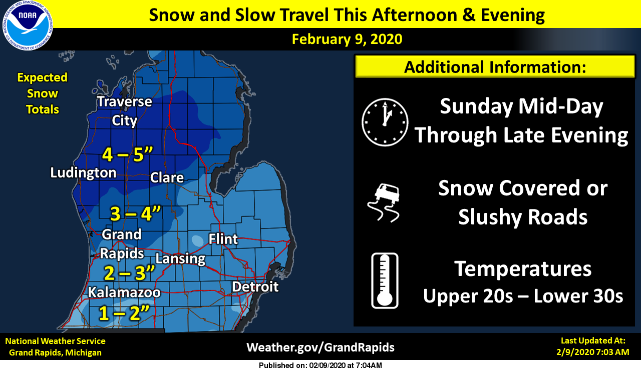
We have a winter weather advisory in place which starts at noon today lasting through midnight for three to five inches of snow with isolated higher amounts. The highest amounts will be north of Grand Rapids while south drizzle may mix in.
We have another chance of snow late Wednesday into Thursday then a brief shot of cold air from our friends in the frozen north country.
Interactive Radar
Temps still climbing, up to 37 now and still a light rain/mist. Funny every time we get a little snow it immediately starts melting away.
Wow Storm team 8 has a high of 18* degrees on Friday thats pretty cold for mid February Valentine’s Day in a hot tub I say …With over 5 inches of snow on the ground out at thee YARDofBRICKS NE of GR have a a nother snowy Sunday night…INDY
18 is certainly not that cold for mid February. This is the time of year we are often around or below zero.
Lol….Ok INDY
Too funny
That’s what I thought. If you’re going to have temps in the teens the most likely months to have that would be January or February. If it was May or June that would be shocking.
Just ran to Holland and the main roads are already mostly melted off. Up to 35 now with light rain coming down.
Officially GR has picked up 3.1 inches and counting! GR is well over 40 inches of snow and going up fast! Might be over 50 inches by the end of the week! Incredible!
3.25 inches and bad roads! Great call for the WWA! Nice little snowstorm and more is on the way next week! Bring it!
Well snow is done here, so I fired up the snowblower just to use up some of the gas I’ve had sitting around, about 1.5 to 2 inches on the driveway. Not enough for the blower, but had to run the engine some. Any normal Winter this would amount to squat for mid February, but this year since we are counting tenths at a time, a whopping 15 to 20 tenths today!! Current temp is 34 and the melting has begun again.
LOL!!! A WWA for the 2” of snow we got here in Northern Kent?!?!? What a joke!!
What a storm! One of the few times the RDB model under estimated the snow totals! Wow!
I love these long winters that start in the beginning of November! Let’s keep this party rocking till April!
I just took a spin outside and we have picked more snow than I thought! Great call by the NWS – the roads are a mess, closing all over the place and this is despite all the warm weather fanatics complaining about the the WWA! Incredible!
Well…not a lot of “fuel” left for heavy snow. Thankfully, not a major impact for W. MI.
We have picked up 2.5 inches and counting with moderate to heavy snow as we speak!
Just another couple day cool down, then right back well above normal for temps!! Short winters are AMAZING!!
https://weather.com/weather/tenday/l/7f39432f98eef2d300f773cf914253d5f248e7131cb69cb63b087ebda662f574
Short winter continues!!! Check out the 8-14 day CPC Map!! That will have Rocky seeing red!!! Love these short snowless winters!! Even after the couple of inches we get today, we’ll still be around a foot and a half below normal for snowfall and February will just be another in a long line of above normal temp months! So awesome that we transitioned from a nice string of cooler than normal months from summer through fall, right to well above normal temps all the way through winter!! Who knew?!?!! Keep it ROCKIN!!
Yup, no ice on the local rivers.. Its been a mild winter for sure.. Bring on spring !
Put up the radar at noon
Latest update from the NWS: Overall our ongoing forecast looks good. The snow has started at Holland already from the lead push of deep moisture. There are two areas of precipitation to watch. Most our CWA is getting snow from a jet exit region lift, which with the axis of the jet core between Little Sable Point and Muskegon this afternoon, would maximize precipitation amounts over then northern half of lower Michigan. The isentropic lift near 700 mb, over most of our CWA at 1 pm this afternoon, shows nearly 50 knots perpendicular to the 700 mb surface over most… Read more »
Very nice detailed assessment!
Breaking weather alert>>>>>>this storm may end up as a bust for GR! Most of the snow will be tracking North of GR and then the dry slot will hit sooner than expected! So don’t be surprised if GR only sees around an inch of snow! The counties to the Northwest may actually see a good storm, 4 to 6 inches up by Cadillac/TC! Snow country baby!
I love these long winters! Starts the beginning of November and may last till April! The snow totals just keep rising! Incredible!
Broke my shovel yesterday. At least I got to use it:) Hoping for enough snow to fire up the snow blower before this time next week… we shall see what old man winter can muster.
Im thinking all of our snow events have been on the weekend this year crazy …. February will be above average in snowfall mark it down …..Let it snow let it snow let it snow … Have a snowy Sunday…INDY
Bring it on!
By the end of the day GR will be well over 40 inches of snow for the season and climbing! Get ready!
We have an incredible week of winter weather on tap! I will be Skiing and snowmobiling as much as possible! Bring it!
http://wxcaster.com/gis-gfs-snow-overlays2.php?STATIONID=GRR
The snow just keeps coming!