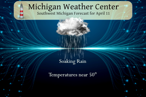
After a beautiful day yesterday with a high of 68° we have a cool and wet pattern for today and tomorrow. We could see a couple of inches of rain through tomorrow night so this will be a time best spent indoors.
Friday will be the most unpleasant with cool temperatures, lingering showers, and northwest winds potentially gusting to 50 mph. Sunny and dry weather returns Saturday with temperatures moderating over the weekend into early next week.
NWS Forecast
Weather History
1965: The second worst tornado outbreak in United States history struck from Iowa to Ohio, killing 256 people. In Michigan, the worst damage is near the Indiana state line as two violent tornadoes moved on parallel tracks about a half hour apart, killing 44 people and injuring hundreds. A tornado struck northwest of Grand Rapids, killing five people in Comstock Park. One person was killed by a tornado that moved from near Dewitt in Clinton County to Bennington in Shiawassee County.
2001: Severe thunderstorms produced large hail, flash flooding, and two weak tornadoes. The tornadoes briefly moved through rural areas near Coopersville in Ottawa County and Cloverville in Muskegon County.
On April 11, 1965, the Palm Sunday Tornado Outbreak occurred. This outbreak mostly affected Michigan, Indiana, and Ohio and produced 47 tornadoes that killed 271 people and injured 3,400 people in just a 12 hour span. Two F4 tornadoes that were a part of this Outbreak affected southeastern Michigan quite severely. These two tornadoes were responsible for 44 deaths, 612 injuries, and over $32 million in damage in Hillsdale, Branch, Lenawee, and Monroe counties.
1965: Severe thunderstorms in the Upper Midwest spawned fifty-one tornadoes killing over 250 people and causing more than 200 million dollars damage. Indiana, Ohio, and Michigan were hardest hit in the “Palm Sunday Tornado Outbreak”. Although no F5s were officially reported, at least 22 were rated as F3 or F4. This is the third deadliest day for tornadoes on record, behind the Super Outbreak of 4/3/1974, and the outbreak that included the Tri-State Tornado of 3/18/1925. Dr. Ted Fujita discovered suction vortices during the Palm Sunday tornado outbreak. It had been believed the reason why tornadoes could hit one house and leave another across the street completely unscathed was because the whole tornado would “jump” from one house to another. However, the actual reason is that most of the destruction is caused by suction vortices: small, intense mini-tornadoes within the main tornado. Click HERE for more information from the NWS Office in Northern Indiana.
1988: Sixteen cities in the western U.S., nine in California, reported new record high temperatures for the date. Afternoon highs of 95 degrees at Sacramento and 96 degrees at Bakersfield, California were the warmest of record for so early in the season.
1989: Forty-four cities in the south-central and eastern U.S. reported new record low temperatures for the date. Lows of 25 degrees at Conway Arkansas, 29 degrees at Dallas/Fort Worth Texas, and 22 degrees at Ozark Arkansas, were April records. Lows of 26 degrees at Hot Springs Arkansas and 31 degrees at Shreveport Louisiana equaled April records.
2012: The deluge began around 3:30 a.m. Over the next few hours, fast-moving hailstones pummeled the area north of Amarillo, Tex., which had lately been sitting in dust due to a lack of precipitation, according to the news organization. The hail mixed with melting hail turning the dust to mud and the mix created four-foot-high mounds that shut down a major highway for the next 18 hours.
More on the Palm Sunday storms from Bill’s Blog.
Forecast Discussion
- Strong System With Heavy Rain Today and Strong Winds Friday

Rain continues to steadily spread northwards into southern Michigan
this morning as a surface low currently moving through the Lower
Mississippi moves northwards. This low pressure system will cause a
mess of weather hazards today and Friday, including widespread heavy
rain and strong winds.

Rainfall will increase in coverage and intensity this morning as the
center of the low travels into Central Indiana and a mature
deformation band sets up over lower Michigan. Moisture quickly
funnels into southern Michigan this morning with precipitable water
values jumping to 1 inch or more by daybreak. There is still a
little variation in the track of the low with most models indicating
a track just east of southeast Michigan. As this system enters the
envelop of short term mesoscale models, further discrepancy on
the placement of the heaviest rainfall amounts has become apparent
with the main area of uncertainty west of US-131. A westward shift
of the low will put the lakeshore area at risk for over 1 inch of
rainfall, while an eastward shift keeps rainfall amounts for the
lakeshore down to 0.5 to 1 inch by the end of tonight. Elsewhere,
rainfall amounts to 1 to 1.5 inch look likely through tonight.
With additional rain expected Friday, total rainfall amounts for
today and Friday may near 2 inches for some areas, especially east
of US-131. This widespread heavy rain will impact rivers, creeks,
and streams though the risk of flooding still remains low. Rain
will decrease in intensity this evening into Friday, though some
light rain may continue until Friday afternoon.

The system deepens into a compact low as it travels into the
vicinity of Lake Huron Friday morning placing a tight pressure
gradient over Michigan. Northeasterly winds will shift northwesterly
overnight tonight and will begin to build after midnight Friday.
Significant 850mb winds of up to 50 to 55 knots set up over the area
after 8am Friday. Per Bufkit overviews, mixing depths will tap
into 40 knot winds Friday morning and afternoon, translating to
surface wind gusts up to 40 to 50 mph. Given the closer proximity
to the surface low, areas east of US-131 will have the greater
potential to see those higher end wind gusts, especially in
Gratiot, Isabella, Clare, and Osceola Counties. Winds will begin
to subside Friday evening as the low travels further northeast.

Overall, expect a soaker today, and a windy and wet Friday.

- Chance for Showers and Storms Saturday Night/Sunday AM

A weak shortwave at 500 mb is shown to move into the Great Lakes
late Saturday into early Sunday. Strong warm air advection is
forecast to occur at 850 mb from 12z Saturday to 12z Sunday, with a
rise in temperatures from 0C to 12C. The GFS and ECMWF indicate a
weak area of low pressure should move from WI to central and
northern Lower MI during this time frame. GFS model soundings for
MOP indicate a substantial dry layer in the lowest 10k ft that needs
to be overcome for precipitation to reach the ground, but steady
moistening of the column may help this occur. Elevated instability
could reach 500-1000 J/kg, so a few thunderstorms may occur in this
warm advection regime. The most likely area to receive a few showers
and thunderstorms would be near and north of I-96 overnight Saturday
into Sunday morning, with most locations dry by Sunday afternoon as
the system moves east of the region.

- Warm with Occasional Storminess Next Week

Ensemble guidance is in excellent agreement with respect to rising
temperatures that will boost highs into above normal territory
beginning Sunday. Upper 60s to mid 70s look commonplace from Sunday
into midweek, warmest away from the cooler waters of Lake Michigan.
Rising upper heights initially dominate the Great Lakes region late
Sunday into Monday, but medium range guidance is indicating upper
troughing across the Southwestern U.S. will press east and form a
closed off upper low (potentially vertically stacked) in the
northern Plains and Upper Midwest by Tuesday. This feature will help
surge a warm front north into Michigan Monday night into Tuesday
with elevated instability possible, maybe even surface based
instability. Some showers and a few storms are possible as this
front moves through. Once it clears, stiff southerly winds are
possible on Tuesday as low level winds markedly increase. NBM
surface wind gusts are already showing 35-40 kts on Tuesday, this
far out. That is indicative of medium range model confidence, so we
will need to fine tune this as the system approaches.

Beyond this, details are unclear because much depends on how far
east this upper low may advance and how the upper level pattern
evolves. If the ridge does not totally break down, some additional
return flow could reinforce upstream thunderstorm activity that
could roll into our region mid week. GEFS and ECE ensemble
membership show widely varied rainfall amounts at this point so many
details need to be ironed out over time.
Snowshoeing anyone???
Thanks for reminding me, gotta get some tee times for Saturday and Sunday afternoon! Gonna be some outstanding golf weather both of those days!
Sunday may be decent, if you don’t mind 25 mph wind gusts!
Not at all if it’s 70 degrees! I don’t need absolutely perfect pristine weather conditions for golf.
Get ready for wind chills in the 30’s tomorrow! Winter like temps in mid April! Wow!
Golf anyone? The Whitecaps will probably get cancelled!
My magnolia just blossomed and my grass is getting green. A pleasant and mild April continues.
Our trees have blossomed just in the past 24 or so hours. I love this time of year.
Just starting the best 6 months of the year now!
Yes, they are popping a little early this year! Hopefully summer is not hot and humid, because that is horrible weather! Sometimes summers are so humid nobody wants to go outside for long stretches! Let’s hope for temps in the 70’s with low dew points!!!!
Bring on the rain!! Need some good rain and then those nice warm sunny days on the weekend to get the morel mushrooms popping and my grass seed growing! Working all day inside today and tomorrow, so it can rain as long as it wants outside!