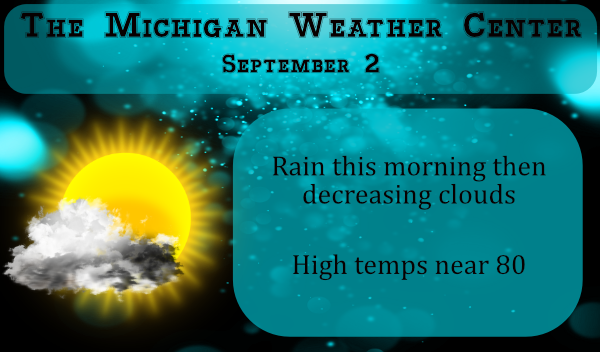
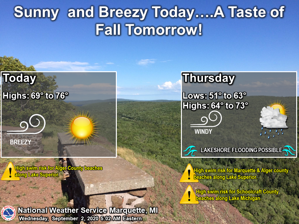
We have some more showers moving through this morning as a continuation of the wet beginning of our Met fall. We picked up .26 of an inch yesterday and overnight in Otsego with a warm 67° at 6 am. After the heat of this past summer, many will be in for a shock when Labor Day rolls around when temps drop into the 60s and low 70s. Today and tomorrow will remain summer-like with temps near normal.
[columns] [span6]
SW
[/span6][span6]
SE
[/span6][/columns]
[columns] [span6]
North
[/span6][span6]
U.P.
[/span6][/columns]
Weather History
August 30
1949: A weak tornado struck just north of Grant in Newaygo County, causing some minor damage to small buildings and crops.
1976: Grand Rapids falls to 39 degrees, the coldest ever recorded during the month of August. Scattered frost occurs in rural areas.
1984: A tornado struck about 5 miles northeast of St. Johns in Clinton County, damaging two homes, but causing no injuries.
August 31
1993: Flash flooding hits Norton Shores in Muskegon County as slow moving thunderstorms dropped about an inch and a half of rain. Elsewhere, three people were struck by lightning in Otsego in Allegan County. One suffered cardiac arrest but was not killed. The other two were treated for minor burns. The lightning strike occurred while two stranded motorists were huddled under an umbrella, watching the wrecker operator connect their vehicle. The lightning struck the umbrella and the motorists, then struck the wrecker operator, jolting him to the ground.
1953: August ends with a late season heat wave that will continue into September. Record highs of 97 are set at Grand Rapids, 96 at Lansing and 91 at Muskegon.
1975: Heavy rains on the last day of the month ensure that this will be the wettest August on record at Lansing and Muskegon. One to three inches of rain falls across the region, boosting the monthly total close to 10 inches.
2009: August ends on a cool note with a record low of 41 degrees at Muskegon. Some other readings include 34 at Big Rapids, 32 at Cadillac and 28 at Leota, in Clare County.
September 1
1953: A heat wave that began in late August continued into September, with record highs of 97 degrees at Grand Rapids and 96 at Lansing. The 95 degrees at Muskegon tied the record high for the month there.
2009: September begins with temperatures more typical of October. Lows include 41 degrees at Muskegon, 36 at Ludington, Hersey and Baldwin, and 35 at Harrison. Cadillac fell to 32 degrees for the second morning in a row, and Leota in Clare County fell to 30 degrees.
2018: Four tornadoes occurred within a two hour period during the evening. The first was a brief tornado that snapped trees near Gull Lake in Barry County. This was followed by a tornado with winds estimated at 100 mph that destroyed a manufactured home at Morley in Mecosta County. Two other tornadoes took down trees, some of which fell on houses, in Jackson and Clinton Counties.
September 2
1894: Lansing hits 99 degrees, setting their record high for the month of September.
1913: Grand Rapids hits 98 degrees tying their record high for the month of September.
September 3
1946: There was an early taste of autumn as Grand Rapids falls to 32 degrees for their earliest freeze on record.
September 4
1965: A tornado struck east of Grand Haven, destroying a barn, silo and factory. Debris was carried over two miles.
2008: The remnants of Hurricane Gustav brought heavy rains to southern Lower Michigan. Muskegon sets a daily rainfall record of 3.25 inches and Grand Rapids sets a record with 2.82 inches.
September 5
1997: Cool weather prevailed with scattered frost and a record low of 34 degrees at Lansing.
Forecast Discussion
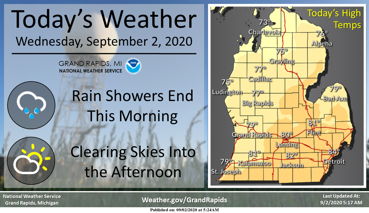
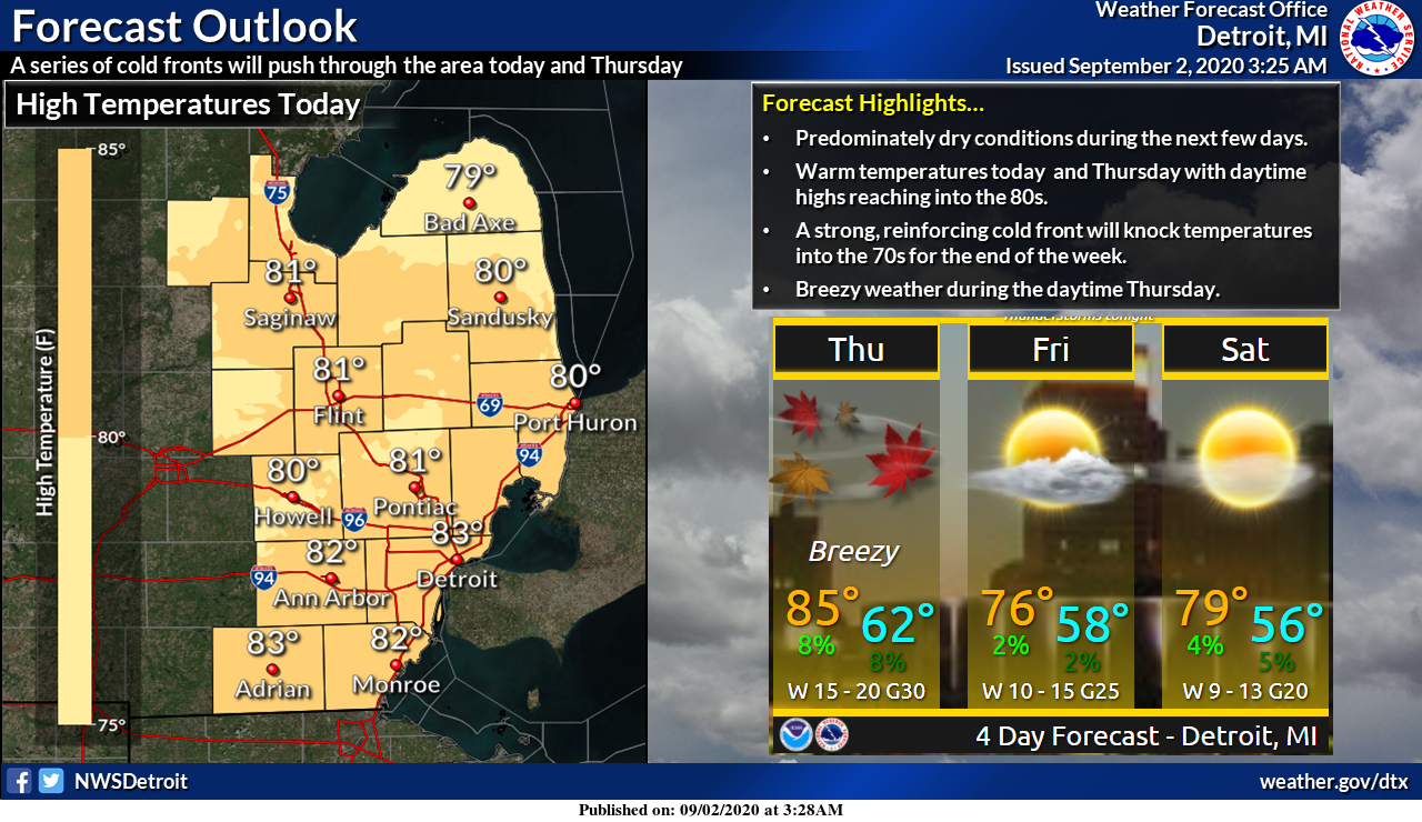
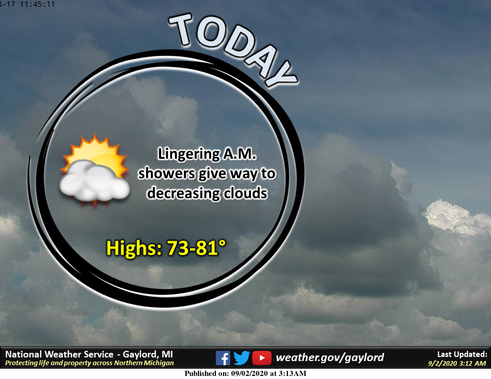
-- Showers end this morning then clearing by noon--

A jet educed frontal wave moving through this area early to mid
morning is bringing and area of showers, some heavy north of a
Muskegon to Mount Pleasant line. There is only marginal
instability with the greatest instability over Lake Michigan. A
40 knot low level jet tracking east northeast, north of Muskegon
by 5 am will be east of Lake Huron by 10 am this morning. So, the
the axis of the low level jet north of I-96, that is where most of
the rain will be between now and say 8 am. Rainfall amounts west
of US-131, and north of Big Rapids may approach an inch in
isolated locations before it comes to an end.

Areas near I-96 and maybe as far south as I-94 likely will see a
period of showers during the mid morning. These showers will move
to toward I-69 by mid to late morning.

Behind the area of showers is a sharp clearing so all areas should
have mostly sunny skies by early to mid afternoon. Since there is
not really any significantly cooler air behind this front, highs
should be in the mid to upper 70s in most locations.

High pressure moving over the area tonight means clear skies and
light winds, through the winds may ramp up toward morning as the
next system will begin to impact our area before sunrise.

-- Cold front brings windy conditions Thursday and cooler
 Friday--

The next system is very strong surface low (upper wave goes
negative tilt) and tracks a 980 mb surface low east northeast near
50N. That is so far north that we do not get much mid level
moisture with this frontal system, so rain seems rather unlikely.
On the other hand, we sure do get the wind with this frontal
passage. At this point is does not look like advisory criteria
winds inland but I could see gusts to near 35 mph. It will be warm
too, highs should be near 80. The cooler air moves in Thursday
night and remains in place Friday. Highs will struggle to make 70
on Friday.

-- A storm system brings showers and thunderstorms by Sunday--

The next upstream system looks more impressive than the Thursday
system and should move into the area by Sunday. The surge of warm
air ahead of the system should bring showers and thunderstorms to
the area by Sunday

--Cooler weather expected by early next week--

The colder air follows by Monday but there is some question as to
what happens to the trailing shortwave, does it close off an upper
low over the western states or dig a very deep eastern trough? If
the GFS version of this happens it will be a very wet and chilly
week.
September is starting warm!
I’m happy to see the cloud cover breaking. There will be flyover today recognizing the end of WW2. A B-17, a B-25, and a C-47 will take off from Ypsilanti later this afternoon. They will fly over the State Capitol around 5:30ish before heading to GR. It’s not every day you get see old planes like that. We are looking forward to it.
It looks like the flyover should be at Grand Rapids at about 6 or so.
Slim
Well my area did receive 0.34″ of rain. So while not a lot it is just enough to keep the grass green. As Barry pointed out it was a mild overnight and IF is stays at 68 or above it will become a tie for the 14th warmest low for any September 2nd. At this time it is cloudy and 69 here at my house.
Slim
Starting to see snow on the maps in the lower 48 next week something to start preparing for folks ….Put away the sprinkler and get out the snow shovel soon…Have a super Wednesday…INDY
Bring on the snow!!!!
Another very mild night last night for this time of the year. Barely got below 70 when average lows are now in the 50{s. We did get another quarter inch of rain though!
Bring on the cool Fall temps and then a rocking winter! Just think in a couple months we can start focusing on multiple snowstorms! Incredible!