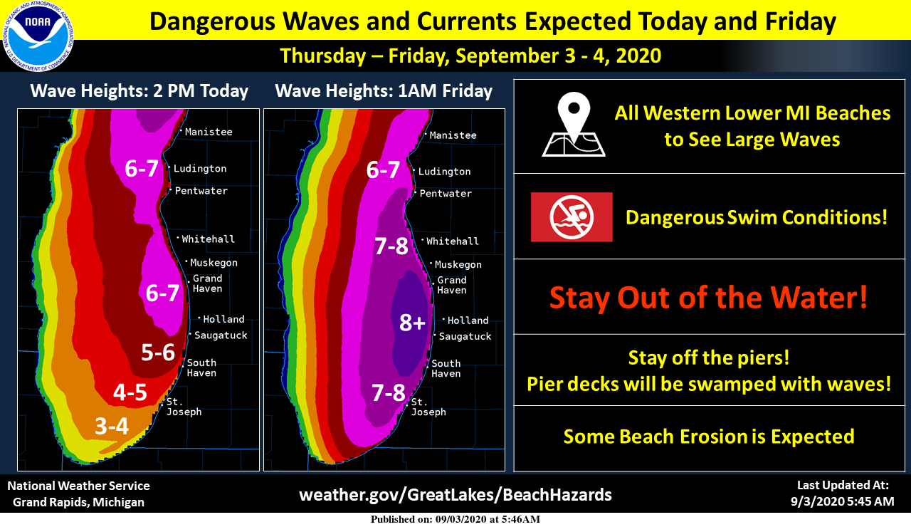
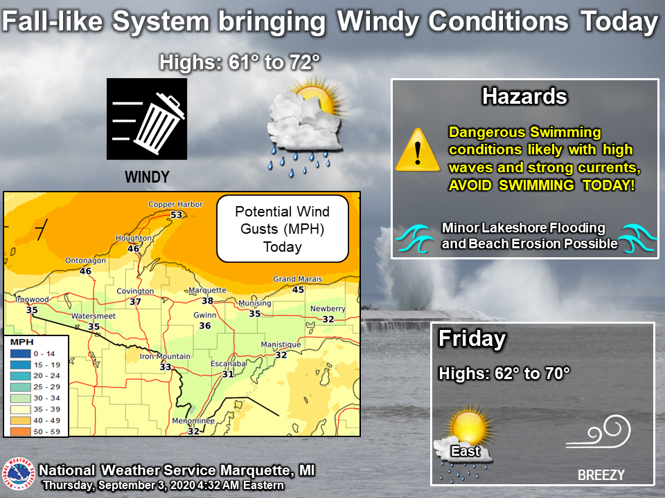
Here in SW Michigan, we look at the wind and wave reports to give us an idea whether or not to go out on the big lake for a swim. Today the worst of the wind will be on Lake Superior where there are gale and lake warnings:
(1 knot = 1.15 mph)
...STORM WARNING REMAINS IN EFFECT FROM 8 AM THIS MORNING TO 8 PM
EDT THIS EVENING...
...GALE WARNING IN EFFECT FROM 8 PM THIS EVENING TO 2 AM EDT
FRIDAY...

* WHAT...For the Storm Warning, west winds 30 to 40 kt with
  gusts up to 50 kt and waves 11 to 16 feet expected. For the
  Gale Warning, west winds 25 to 30 kt with gusts up to 40 kt
  and waves 9 to 14 feet expected.

* WHERE...Manitou Island to Point Isabelle MI, Lake Superior
  East of a line from Manitou Island to Marquette MI and West of
  a line from Grand Marais MI to the US/Canadian Border Beyond
  5NM from shore and Lake Superior from Grand Marais MI to
  Whitefish Point MI 5NM off shore to the US/Canadian border.

* WHEN...For the Storm Warning, from 8 AM this morning to 8 PM
  EDT this evening. For the Gale Warning, from 8 PM this evening
  to 2 AM EDT Friday.

* IMPACTS...Very strong winds will cause hazardous waves which
  could capsize or damage vessels and reduce visibility.
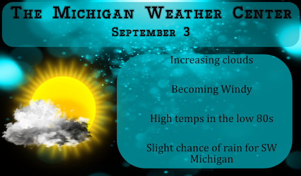
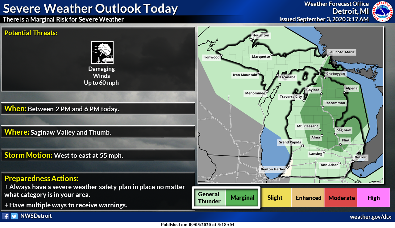
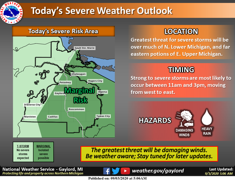
We have lake warnings and advisories on most of the great lakes this morning. As far as stormy weather goes the NWS has the marginal outlook for most of northern Michigan for severe storms. SW Michigan has about a 20% chance of rain this evening.
A cold front sweeping through on today will bring windy conditions. Southwest winds of 15-30 mph will gust at times to 30-40 mph midday and afternoon. Lake Michigan will quickly turn rough today with waves building to 5 to 8 feet. Large waves will continue tonight and into Friday as well.
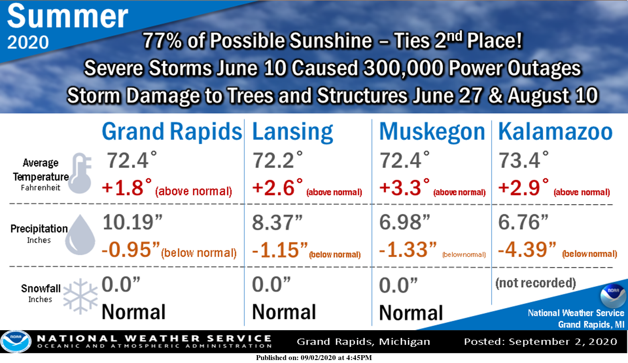
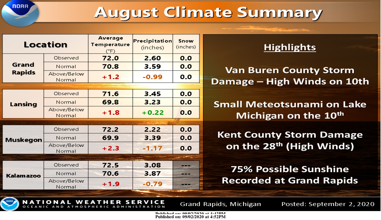
Here are the Summer and August summaries for SW Michigan:
[columns] [span6]
[/span6][span6]
[/span6][/columns]
[columns] [span6]
SW
[/span6][span6]
SE
[/span6][/columns]
[columns] [span6]
North
[/span6][span6]
U.P.
[/span6][/columns]
Typhons in the Pacific have an impact on our weather and to the chagrin of our Mets can impact mid-range forecasts day to day. Our cooler weather pattern predicted for next week may get pushed back until late in the week:
Forecast Discussion:
-- Windy today, brief showers midday with gusty winds--

It would seem our digging northern steam jet (130 knots at 300 mb)
reaches the base of the deepening upper trough around midday over
central Lower Michigan. This is a touch farther south than I was
expecting, so the threat for convection has increased with that.
There now is a low level jet that develops in response to this by
midday, of around 40 knots just north of I-96. There is also
decent 1000/850 moisture convergence and transport, which is
maximized near MKG at 18z but that quickly races east with the
associated low level jet and upper jet entrance region. I would
think if you live near or north of I-96 it is more likely than not
you will see at least 0.01 inches of rain today. Any shower would
be brief (less than 10 minutes) but could be locally heavy.

We have a synoptic wind gust threat today due to the 980 mb low
just north of Lake Superior this afternoon while there is a 1020
mb high over Nebraska at the same time. The ECMWF and HRRR wind
gust forecast is showing 20 to 30 mph for generic wind gusts
today inland.

On top of that we have convective wind gust threat too. Now we have
all of our high resolution models forecasting a narrow band of
convection crossing our CWA, mostly near and north of a Holland to
Lansing line from early to mid afternoon. The mixed layer reaches
to near 800 mb and mixes down 45 knots (HRRR) with the convective
line. We even have an inverted "V" look to our models sounding
ahead of the front. SPC has us in a Marginal Risk for severe
storms today. That is due the potential for convective gusty
winds. I would expect synoptic scale gusty winds today across the
CWA but with the convective line, winds may gust to 40 to 50 mph
with the convective line (from HRRR and ECMWF 00z run). Since the
polar jet core reaches near I-96 this afternoon, area near and
north of that would have the greatest threat for convective wind
gusts today.

-- Beach hazards and Small Craft through Friday--

Given all of the above, we will have strong winds over the Near
Shore waters and with the polar jet core near I-96 this afternoon
the strongest wind will be north of that in the "deep cold air".
Once the front is through the cold advection (850 temps fall 10c
behind the front) will drive gusty winds into Friday afternoon.
The lake being warm yet, near 70F, and having air over the lake
colder than the surface lake temperature by 5 to 10 degrees, that
too will help mix down stronger winds.

-- Cooler and dry Friday --

The polar jet lifts north of this area during Friday afternoon and
surface high pressure passes south of the state on Friday. So
here is the glitch. We have a warm front coming through Friday
night. There is strong warm advection and an associated
shortwave. So while the mid levels are more or less dry, there may
be enough lift for a few showers early to midday Saturday.
Whatever falls form this will be very light if it even reaches the
ground.

-- Warming over the weekend--

Our next upstream Pacific system will force the system that is
moving into today out of the area and bring shortwave ridging
later Saturday into Sunday. That is behind that warm front related
shortwave that comes through early to midday Saturday. This brings
in warmer air for Saturday and even more so Sunday.

-- Could get hot early to middle of next week --

So, here is were the bigger forecast glitch is. We now have two,
count them, two western Pacific typhoons. The first is Maysak,
that not to far behind that is Haishen. Both of these storms
recurved and head north up the coast of eastern China, Korea and
Russia. That has a rossby wave impact on the down stream systems.
It causes amplification of those systems. It is for that reason
the ECMWF slowed down our cooling. The GFS is catching on some
with the latest model run.

The more amplified pattern over the Pacific results in a more
amplified pattern over North America. That means the system that
was suppose to dig into the Great Lakes now digs into the western
Mountains instead. That in turn allows the Azores high to expand
westward, which in turn keeps us warm until that upper trough
slowly makes it far enough east to reach the Great Lakes. Remember
both typhoons have to finish recurving for it to get cold here.
That may delay the cold weather until the following weekend.

Meanwhile, with the upper high building back toward the Great
Lakes we may have highs in the upper 80s to lower 90s Monday into
Thursday. By the way it is not unusual to us get hot weather the
first week or so of September. In fact the average high
temperature for the first week of September in GRR from 2011 to
2019 is 80 degrees. Which is about 3 degrees above normal. Prior
to that, from 2007 to 2010, it was cool the fist week of
September with our mean high only being 75 degrees.
We just had the dog out for last call and it is 68 degrees out and no wind. There sure is a beautiful moon out tonight in a clear sky.
Currently 68* degrees out at thee YARDofBRICKS NE of GR probably draining few out lol….But definitely you can feel Fall in air outside love it ….INDY
now down to 67 here with clear skies
Slim
Yes another night with no Fan attached love it!!! Great sleeping weather!! INDY
Breezy days are a favorite…
I just got back from a nice walk. It is windy but very warm out here at this time. I have a reading of 86 with that wind. There is a deck of clouds to the north but the sun is still out here.
Slim
Mid 80’s already before 2pm. Warmer than expected today!
“Meanwhile, with the upper high building back toward the Great Lakes we may have highs in the upper 80s to lower 90s Monday into Thursday.” NWS GRR WOW!
That’s going to be a tough pill to swallow for some. Going to get awfully sweaty in those hoody’s.
WOOD still has 60’s for next week. If the NWS outlook plays out, their forecast could be almost 30 degrees off! LOL
Well, today looks like our third warm day in a row to start September… and the big cool down some on here have been hyping for weeks seems to have been lost. Who knew?
It is always tragic when people are swept away and drown on the big lake, but man, where is the common sense? Huge waves crashing over the piers isn’t enough to stop them from going out there?
The overnight low here was 58. At this time it is clear with a temperature of 64. It now looks like there is a chance that it could get rather warm again next week.
Slim
Oh boy, what a surprise. We don’t seem to get much of any lasting cool downs this year.
Clouds cool temps light showers big waves doesn’t get any better then today love September … Have a nice thirsty Thursday ….INDY