February 25
1957: Mild and rainy weather prevails with lows in the 40s and highs in the 50s. The low of 47 degrees at Grand Rapids sets a record for the warmest low temperature for the date. Over an inch of rain falls as a cold front moves through.
February 26
2000: Record warm weather continues during a week long spell of balmy weather across Lower Michigan. The temperature hits 66 degrees at Muskegon for a record high. The low temperature at Grand Rapids is 53 degrees, setting a record for the warmest low temperature for the month of February.
February 27
1976: Temperatures soar to the upper 60s during a spell of spring-like weather during the last week of February. Record highs include 62 degrees at Muskegon and 67 at Lansing.
February 28
1998: Record warm temperatures include the high of 53 degrees at Muskegon and 54 at Grand Rapids, helping to make this the warmest February on record at those sites.
March 1
1882: March comes in like a lamb with high temperatures in the 60s. Lansing hits 64 degrees, and goes on to reach 66 degrees the next day. This continued the warmth from the previous month, which was the warmest February on record at Lansing.
1962: Bitterly cold weather begins the month with morning lows below zero and high temperatures only around 10 degrees.
March 2
2002: A strong low pressure center moves across the Ohio Valley bringing record snows to Lower Michigan. Grand Rapids has 13. 9 inches and Muskegon 10.5 inches, both set records for their snowiest March day on record.
March 3
1943: Arctic air dominates the first ten days of the month. Record cold temperatures this morning include the 10 below zero at Muskegon and the 9 below at Grand Rapids.
1983: Record highs are set across Lower Michigan with Grand Rapids hitting 72 degrees and Muskegon 69 degrees. The first week of March is incredibly balmy with six straight days of high temperatures of 60 or above at Grand Rapids.
Looking back through February records the Iran Blizzard of February 1972 was the deadliest blizzard in history. A week-long period of low temperatures and severe winter storms, lasting February 3 – 9, 1972, resulted in the deaths of approximately 4,000 people. Storms dumped more than 10 feet of snow across rural areas in northwestern, central and southern Iran.
Southern Iran received as much as 26 feet of snow, burying at least 4,000 individuals. According to contemporary reports by the newspaper Ettela’at, the city of Ardakan and outlying villages were hardest hit, with no survivors in Kakkan or Kumar. In the northwest, near the border with Turkey, the village of Sheklab and its 100 inhabitants were buried.
 February is drawing to a close and spring isn’t far away as our warm temperatures indicate. Our rainfall for February is at 5.25 inches for Otsego.
The Kalamazoo river level has dropped though it is still over its banks, I will walk down there this weekend to check it out and get some more photos.
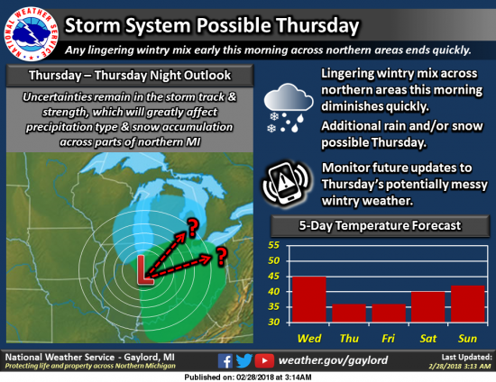
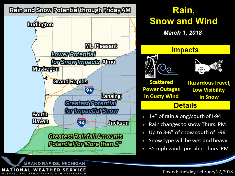
March can hold surprises weather wise as our next storm system creeps towards us. The track is still uncertain though it appears it will be a rain/snow event with most of the rain falling from I94 to the south and 3 to 6 inches of wet snow from Kalamazoo to Grand Rapids and to the east. Won’t be surprised if Winter Weather Advisories go up later today.
The morning NWS statement: The developing low pressure system will move through the Southern Great Lakes region tonight and Thursday bringing both rain and snow to the area. Some scattered rain showers are expected today, but the more organized, persistent rain will show up late tonight towards Interstate 94.
Colder air will be pulled into the system on north winds Thursday and allow a mix with and change over to snow in parts of the area. Some rainfall totals may exceed an inch across Southern Lower Michigan by Friday morning. A swath of snow is beginning to look more likely from South Haven east-northeast towards Lansing. Much of the area may see a wet inch or two of snow, but in the heavier band totals of 2-4 or locally 3-5 inches look possible. Dry and colder weather is expected on Friday.
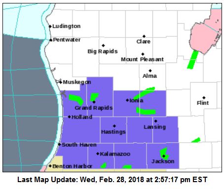
3PM update: Winter Weather Advisory for Ottawa-Kent-Ionia-Clinton-Allegan-Barry-Eaton-Ingham-Van Buren- Kalamazoo-Calhoun and Jackson Counties FROM 9 AM TO 10 PM EST THURSDAY… Looking at the latest model data it appears the heaviest snow may fall in southern Allegan County and to the east…..
Aurora Borealis photo of the Day from Northern
Michigan
Beautiful! Thanks for sharing.
Lansing set a record high of 60° today. The old record was back in 1880. GR also hit 60°, which was also a record, but the old record was from just two years ago.
Accumulating SNOW in March! Bring it!
I would suggest that since the ground is now thawed and warmed from the temps and sun the past 2 weeks, and by Friday and Saturday temps will be back in the mid 40’s, that you should be standing outside if and when the snow falls tomorrow to play in it because it is not going to last very long.
Back to back 60 degree days in February!! Bring it!!!
So….all the board excitement about 1.5 inches of snow??? Then quickly melts on Friday & Saturday! Goes to show how snow starved this area has been!
Thursday
Rain and snow, becoming all snow after noon. High near 36. Breezy, with a north northeast wind 15 to 21 mph. Chance of precipitation is 80%. New snow accumulation of around an inch possible.
Thursday Night
Snow, mainly before 1am. Low around 27. North northwest wind around 11 mph. Chance of precipitation is 80%. New snow accumulation of less than a half inch possible.
Just for fun, here is mine:
Thursday
Rain before 11am, then rain and snow between 11am and 2pm, then snow after 2pm. Temperature falling to around 31 by 5pm. Breezy, with a north northeast wind 13 to 21 mph, with gusts as high as 30 mph. Chance of precipitation is 90%. New snow accumulation of around 3 inches.
Thursday Night
Snow, mainly before 1am, then a slight chance of snow showers after 1am. Low around 27. Northwest wind 10 to 14 mph, with gusts as high as 24 mph. Chance of precipitation is 80%. New snow accumulation of around 2 inches.
Back-to-back 60 degree days.
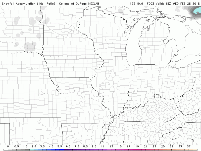
IN the NAM we trust!
http://www.pivotalweather.com/model.php?m=nam&p=snku_acc&rh=2018022812&fh=84&r=conus&dpdt=
WINTER WEATHER ADVISORY IN EFFECT FROM 9 AM TO 10 PM EST
THURSDAY…
* WHAT…Rain changing to snow. Snow will become heavy at times.
Total snow accumulations of 2 to 6 inches are expected.
* WHERE…Portions of south central and southwest Michigan.
So is this lion or lamb weather?!?! I guess if it’s windy I would say lion. LOL!!!
I would say the lion is dining on the lamb tomorrow especially when you figure in the wind gusts…
You could be right!!! LOL!!! It may look lamb- ish when the snow falls. LOL!!!
Bring it and our trend of above normal snowfall continues!
It looks like another beautiful warm weekend coming up after the storm. 40 Friday, 42 Saturday, 46 Sunday with lots of sun each day.
>>>>WEATHER ALERT>>>>WWA’s will be issued! Get ready now!
March 1st = 2 to 4 inches of SNOW for GGR! Get ready for a return to winter! I love it!
We now have back to back 60+ degree days in Detroit and the third 60+ day of the month. I can’t believe this is February!
Here is the 10:30 NAM run for tomorrow
That’s what happens when I “think” about cleaning all the snow stuff. I knew better though. I guess it still jinxed us. LOL!!! It will be fun to see how this all plays out.
Glad I did not put the snow shovel away just yet … indydog14!!
Go from highs in the 50’s today to 6+ inches of snow tomorrow only in Michigan … indydog14!
Actually happens out West a lot. I’ve been in Denver before when it was in he 70s one day, and a blizzard the next. Montana, Minnesota, and the Dakotas get that quite often as well.
Here is the WPC’s take on the snow potential for the upcoming storm system’
4” or more
http://www.wpc.ncep.noaa.gov/wwd/day2_psnow_gt_04.gif
8” or more
http://www.wpc.ncep.noaa.gov/wwd/day2_psnow_gt_08.gif
12” or more
http://www.wpc.ncep.noaa.gov/wwd/day2_psnow_gt_12.gif
slim
Bring on the SNOW! Rock n Roll baby!
What a winter! The following major reporting stations in Southern MI are all above normal for snowfall and more snow is in the forecast! Who would have thought? Grand Rapids, Muskegon and Lansing! INCREDIBLE!
And what’s more incredible is that the ground has been void of snow for most of the past two months!
Funny, because I have skied or snowmobiled for 11 straight weeks! Boyne MT was hoping this past weekend with great conditions!
LOL You can do that every single winter in Northern Michigan. We’re not talking 200 miles north here.
Thanks to the recent snow drought, GR is now only 2″ above the average for this time of year and still below the total winter seasonal average.
All of Northern Michigan remains well below average in terms of snowfall with Gaylord and Alpena more than 2 feet below average!
https://www.weather.gov/apx/snowgraph_ytd
Not sure about Gaylord but Aplena well below average snow fall last winter as well so it been two years in a row for them.
Slim
I think we still have to keep a eye on tomorrows system. The storm track is in a location that can bring a lot of wind and snow to Michigan and it is still only March. Time to see if all of the expensive models can really pick up on the old “surprise” storms. I have a felling this storm could be one of the old time “surprise” storms with so keep a eye out for that to happen’
Slim
GR is currently +2.4 degrees above average for February, and today marks the 15th day in a row of average to warmer than average temps.
This will be end up being a wet and mild February even after its cold start. The big item this year was the amount of water that fell
Slim
Final day or meteorological Winter today, so we can now look back and compare it to last year. Obviously we had some colder spells, but both are remarkably similar in the fact that both Winters had almost all the snow come in 1 or 2 week stretches, followed by record to near record warmups that wiped the ground clear of all the snow. Both Winters had January and February thunderstorms, crazy amounts of rain, and almost all the snow around here came from lake snow with no major synoptic events. Now the question is will this Spring be another inactive… Read more »
Over all a nice recap. I will put up a short recap tomorrow when meteorological Winter winter is over.
Slim
We are above normal for GR seasonal snowfall and no change in sight! Keep it coming!
Highs only in the 30’s next week what happened to a early Spring I was loving yesterdays temps… INDYDOG14!!
Winter is still in full force! Who would have thought? What a winter! Above normal snowfall!!!!!!!!!