Our mostly snow-starved winter continues. We are looking forward to some sunshine moving into the area Friday through the weekend to break up the cloudy pattern we have had most of the month. We will see a warming trend into the mid 40s into next week. For snow enthusiasts, you may have to wait a couple of weeks before the possibility of another cold air dump from Canada.
Forecast
Weather History
1914: A snowstorm drops from 6 to 14 inches of snow across southern Lower Michigan.
1977: One of the coldest months on record comes to a close with yet more arctic air and lake-effect snow. High temperatures are only in the teens during the last week of the month with 2 to 4 feet of snow piled up along the Lake Michigan snow belts.
On January 31, 2019, record cold lingered across the region. Detroit and Flint each experienced a high temp of 3 degrees and a low temp of -14 degrees which easily beat the respective previous records. Both sites spent 36 consecutive hours below 0 degrees during this cold snap. Wind gusting over 35 mph at times resulted in wind chills near or below -35 degrees for numerous hours.
A snowstorm in 1982 brought our 13th biggest snowstorm to the metro Detroit Area. The snow began late on the 30th and continued throughout much of the 31st. When it ended, nearly a foot /11.8″/ was officially measured at Detroit Metro Airport.
U.S.A and Global Events for January 31st:
1911: Tamarack, California, was without snow the first eight days of the month, but by the end of January, they had been buried under 390 inches of snow, a record monthly total for the United States. By March 11, 1911, Tamarack had a record snow depth of 451 inches.
1950: Seattle, Washington experienced their coldest temperature on record with a reading of zero degrees.
1979: A winter storm that started on the previous day and ended on this day spread 2 to 4 inches of rainfall in 24 hours over much of coastal Southern California and two inches of snow in Palm Springs. Snow fell heavily in Palm Springs, and 8 inches fell at Lancaster. All major interstates into Los Angeles were closed. Snow drifts shut down Interstate 10 on both sides of Palm Springs, isolating the city.
1989: The barometric pressure at Norway, Alaska, reached 31.85 inches (1078.4 mb) establishing an all-time record for the North American Continent. The temperature at the time of the record was about 46 degrees below zero. The severe arctic cold began to invade the north-central U.S. The temperature at Grand Fall, Montana, plunged 85 degrees in 36 hours. Valentine, Nebraska plummeted from a record high of 70 degrees to zero in just nine hours. Northwest winds gusted to 86 mph at Lander WY, and wind chill readings of 80 degrees below zero were reported in Montana. Sixty-four cities in the central U.S. reported record highs for the date as readings reached the 60s in Michigan and the 80s in Kansas.
Forecast Discussion
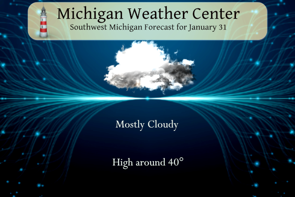
-- Mostly Cloudy End of January --

The past few hours have seen a significant reduction in the
number of quarter-mile visibility obs. While areas of fog may
linger through the morning, the lessening threat of widespread
dense fog should justify canceling the dense fog advisory.

Layer of low stratus clouds envelops Lower Michigan and extends
back to west of the Mississippi river. IR satellite shows some
thinning spots or breaks in the stratus in Wisconsin and
Illinois. Forecast model soundings this afternoon are not overly
optimistic for sunshine, but there are some hints of saturation
layers becoming shallower in the presence of midlevel
subsidence and warming. So some glimpses of sunshine could
occur. High temperatures around 40 today would be nearly 10
degrees above normal. Lows tonight in the mid 30s are even more
substantially above normal.

-- Fog or Drizzle Tonight into Thursday Morning --

Pressure gradient strengthens tonight, between a northern
Ontario low and a southeast US high, and wind gusts 15 to 25 mph
are expected. Low-level warm air and moisture advection with
lift present in the thickening cloud layer should support misty
conditions or areas of fog during the night into Thursday
morning. Will throw in a chance of drizzle over much of the area
also. Several models among the HREF membership output a couple
hundredths inch of QPF.

-- Mild and Possibly Sunny in Early February --

Odds favor our region staying mild and dry through the first week of
February. High pressure looks to take shape from the surface all the
way up to 250mb believe it or not, starting Friday and lasting into
the weekend. We may continue to be influenced by anomalously high
upper heights and tranquil lower atmospheric conditions into early
next week. Low clouds finally look to get booted out of the region
for awhile once we get into Friday afternoon or so. More sunshine
than we`ve seen in quite some time looks to arrive for the weekend
with ensemble guidance and deterministic model RH layers continuing
to suggest good sunshine coverage. With our region heavily favored
to be precipitation-free early next week, additional periods of sun
may yet be on tap. By mid to late next week, some rain showers may
move in to the Great Lakes region as the next in a series of Pacific
waves tries to advance across the central CONUS.
Another bad year for ice fishermen. The annual sturgeon season on Black Lake may be canceled. I don’t recall that ever happening.
Here’s the latest on the Great Lakes ice – or lack thereof. The most interesting takeaway from the piece is that it appears that we’re already past peak ice for the season.
https://www.mlive.com/weather/2024/01/great-lakes-ice-cover-doing-almost-the-unthinkable.html
Wow! No ice also means warmer temps and a warmer spring!
Yup, pretty sad. I really hope we swap to colder pattern next winter. The past few have been bad for winter outdoor activities.
NWS says mild and dry with sunshine coming up the next couple weeks. What could be better? It’s been a 2 week winter!
Yesterday Mark asked if January 29th was (On average) the coldest day of the year. At Grand Rapids the 30 year average H/L reaches its coldest of 30.4/17.4 on January 25th and stays there until 27th it starts to go up from there. At Lansing the coldest starts on January 24th with a average H/L of 30.1/16.1 and it starts to go up on January 29th but see the reply below.
Slim
On the new 15 year average the coldest days at Grand Rapids start on February 1st with a average H/L of 30.5/16.9 and stay that way until February 5. At Lansing the coldest days start on January 31 with a average H/L of 29.4/15.4 and stay there until February 3rd . So in the most recent 15 years the coldest days have shifted into very late January into the start of February. That will not be the case this year.
Slim
Thanks Slim.
The official H/L yesterday at Grand Rapids was 35/32 there was 0.02” of precipitation of that 0.1” was reported as snow. There was a trace of snow on the ground. Here NW of GR there is still a lot of snow in spots but also a lot of bare spots. Once again no sun yesterday. For today the average H/L is 31/17 the record high of 57 was set in 1989 and the record low of -20 was set in 1899. The record snowfall of 14.0” fell in 1918. The most on the ground was 21” in 1978. There was… Read more »