We may begin to see some appearances of some sunshine today with better chances tomorrow on through the weekend. Temperatures will be more like March than early February.
Despite very cold temperatures and snowy weather in the middle third of the month, January was bookended by mild temperatures, particularly daily low temperatures well above normal, and ultimately the month ended up warmer than normal when all averaged out.
At Grand Rapids and Lansing, it was the snowiest January since 2014. The month started and ended without natural snow cover across most of the area (ignoring the lingering piles of plowed and shoveled snow). Precipitation totals through both rain and the water content of snow were much above normal in the southern half of the lower peninsula of Michigan, and this resulted in minor river flooding in a few spots late in the month.
At Grand Rapids, January was among the top 4 cloudiest on record with only 8 percent of possible sunshine (1998 had the cloudiest January with 6 percent).

Forecast
Weather History
1918: February opens on a frigid note during one of the most severe winters in history across the central and eastern United States. Muskegon tumbles to a record cold 22 degrees below zero and Lansing also sets a record with 16 below.
On February 1, 2015, a snowstorm for the record books blanketed the Great Lakes Region in snow. Light snow began in the predawn hours and gradually intensified until accumulation rates reached one inch per hour in the early afternoon and persisted into the evening.
As snow tapered off late that night into the following morning, amounts at Detroit had reached 16.7 inches, its third biggest snowstorm on record. In Flint, the total of 9.2 inches was its 22nd biggest snowstorm while the 11.2 inch total at the NWS White Lake was the 8th biggest in its rather abbreviated climate record.
Also, on February 1, 2014, a general 3 to 6 inches of snow fell across Southeast Michigan, including 4.1 inches in Detroit, 3.5 in Flint, and 3.6 in Saginaw. Port Huron measured the greatest accumulation of 7.5 inches.
Also, on February 1, 1881, a two-day snowstorm dropped 12.5 inches of snowfall on Detroit!
U.S.A and Global Events for February 1st:
1916: Seattle, Washington, was buried under 21.5 inches of snow, their most significant 24-hour snowfall. A total of 32.5 inches of wet snow accumulated over three days. The Seattle cathedral dome collapsed under the snow’s weight. Click HERE for more information from Scott Sistek at KOMONews. Click HERE for a YouTube video.
1947: January 30th through February 8th, a great blizzard occurred in Saskatchewan, Canada. All highways into Regina were blocked. Railway officials declared the worst conditions in Canadian rail history. One train was buried in a snowdrift over a half-mile long and 36.7 feet deep. Click HERE for more information from Environment and Climate Change, Canada.
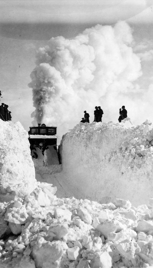
The photo above is of a C.N.R. train buried by a snowstorm of February 9, 1947, near Weyburn, and an effort to dig it out. SK Archives Photo R-A9033-8.
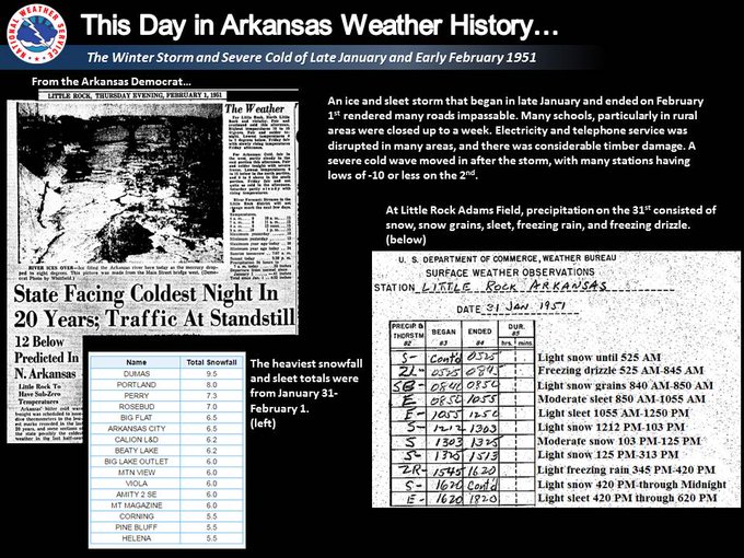
1951: An ice and sleet storm began in late January and ended on February 1st rendering many roads impassable. Electricity and telephone service was disrupted. The graphic below is from a tweet by the NWS Office in Little Rock, Arkansas.
1955: Seen first as a “well-defined cone-shaped funnel” over the Mississippi River, this F3 tornado cut a path from Commerce Landing to Clark in northeastern Mississippi. This tornado killed 20 and injured at least 141 individuals. Most of the deaths were in a plantation school. The following is from Thomas Grazulis, “Significant Tornadoes 1680-1991” book: “Despite the fact that a funnel was seen, that heavy objects were thrown long distances and that the tornado was in a forecast box, the event was not officially called a tornado. A survey team stated that since all debris was thrown in one direction, the event should not be listed as a tornado.” Click HERE to read more about this event from the Monthly Weather Review.

2011: One of the most significant events of the 2010-2011 winter season affected a widespread region from Texas to the Midwest and Northeast from February 1st to 3rd 2011. The system produced widespread heavy snow with blizzard conditions and significant freezing rain and sleet to other locations. Snowfall amounts of 10 to 20 inches were common from northeast Oklahoma to lower Michigan. The storm produced 20.2 inches in Chicago, the third heaviest snowfall in the city since their records began in 1886, along with a peak wind of 61 mph. Kansas City received just under 9 inches of snow. The high temp was 17 degrees. Click HERE for more information from the Weather Prediction Center.
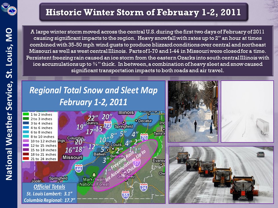
The graphic above is from a tweet by the NWS Office in St. Louis, Missouri.
Forecast Discussion
--Some sun possible today and Friday, sprinkles this evening?--

The stratus clouds upstream evaporated and cleared out more than
previously expected, so the end result of the somewhat drier
air flowing in is less potential for fog and drizzle today, and
maybe even morning sunshine in some areas. A cold front will
pass through from north to south today, turning winds from west
to north behind it. The combination of residual high RH in the
low levels, diurnal mixing, and lift in the vicinity of the
front may lead to stratocumulus redeveloping in the afternoon.
Kept a chance of a sprinkle or flurry in the forecast early
tonight around Lansing and Jackson.

Cautiously optimistic for partial sunshine on Friday with
subsidence under an approaching amplified upper-level ridge and
surface high, and arrival of slightly drier low-level air.

--Mild and dry into late next week--

Warmer and drier than normal will be the rule through at least
the middle of next week before some rain chances arrive perhaps
by Friday. While El Nino already peaked in intensity and is on
the decline, it is still fairly strong and continues to have an
outsized influence on the synoptic pattern across North America.
Very anomalous upper heights will be in place across the
region, extending well into Canada. The 850mb temperature
departures throughout much of the Canadian provinces and into
the Hudson Bay area will be an astounding 20C-30C above normal
heading into the weekend. Suffice to say, winter will continue
to be on hiatus for awhile.

Prospects continue to look very good for sunshine later Friday
and lasting through the weekend, possibly beyond. Deep high
pressure along with low RH throughout the atmosphere should help
ensure mainly clear skies. Some clouds will likely return early
next week, but even then we still may have some intervals of
sun. Ensemble guidance suggests that some of the western CONUS
troughing may work its way toward the central U.S. and Great
Lakes by late next week, bringing with it a chance for some rain
showers.

CPC has Michigan solidly in the outlook for above normal
temperatures into mid February. ECE/GEFS weeklies both indicate
a transition to colder readings right around or just after the
midpoint of the month as there is some suggestion for upper
ridging to develop across the western CONUS and Alaska, leading
to downstream troughing across the central and eastern U.S.
Wow! I am surprised GR was only 9” above normal. It seemed like it was so snowy. But I guess it just came over a short period. Our snow has largely disappeared now too. Large open areas with the grass popping through. It lasted longer than I thought it would.
Probably going to get the grill out on Sunday and enjoy the beautiful sun and warmth!! Who wouldn’t want sun and warmth this time of year??
Today is day 10 of the consistent double digit above average warmth – with at least another 10 very mild days upcoming. Wow!
The incredible pattern of warmth continues!
Don’t hear much from the cold weather crazies these days…
Must be hibernating LOL!
The first half of February looks to be uncharacteristically warm. The second half may be normal or even below normal, but not cold.
https://www.mlive.com/weather/2024/02/new-february-forecast-is-no-brainer-early-then-returns-to-winter-late.html
We have gained almost one hour of sunlight since the solstice. Yay!
As expected, WOOD keeps bumping temps. Next 8 days are now all between 41-48 degrees. Blowtorch warning remains in effect!
Another warm month despite all the cold weather hype! How can that be?
LOL! I look back at these late May posts and think ohhhh Karma, you just right the wrongs of the past!
Rocky (Rockford)
What? A frost advisory for Kent County and GR with temps in the 30’s! Who would have thought? Certainty not the warm weather fanatics! Incredible!
May 24, 2023 8:19 am
What is that glowing yellow ball in the sky?? It sure is nice to to see the sun!!!
Send it this way, PLEASE.
We struck out today. No sun at all. 🙁
Welcome to February. A quick recap of January 2024. The mean at Grand Rapids was 27.1 that is +2.3 above average. It was indeed a odd month with 13 days in a row of above average to start 9 days in the middle with below average and then 9 days in a row to end. There was 31.3” of snowfall that was above the average of 22.6” it was a wet month with 4.62” of precipitation well above the average of 2.52” while a mild the highest reading of 40 on the 28th was the coolest maximum for any January… Read more »
The official H/L at Grand Rapids yesterday was 39/34 there was no rain/snowfall and there was no sunshine. The average H/L for today is 31/18 the record high of 51 was set in 1968 and 1989. The record low of -20 was set in 1899. The most snowfall of 8.8” fell in 2015 the most on the ground is 18” in 1959 and 1918, there was 17” on several more years the last time was in 2014. Last year the H/L was 26/10 and there was 6” of snow on the ground.
Slim